|
DESCRIPTIONS of ORE DEPOSITS & PROGRAM
|
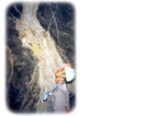
Image: Quartz-adularia-gold scale in pipes,
Hatchobaru geothermal power station, Japan.
|
The tour program included the following:
Japan - with Prof. Sachihiro Taguchi.
Hishikari, Kyushu, Japan - adularia-sericite low sulphidation.
Kasuga, Kyushu, Japan - high sulphidation.
Martabe, Sumatra, Indonesia - high sulphidation.
Lihir, PNG - quartz-sulphide Au (-Cu) low sulphidation.
Hidden Valley, PNG - carbonate-base metal-Au low sulphidation.
Wafi & Golpu, PNG - high sulphidation & porphyry Cu-Au.
Pajingo, Qld, Australia - adularia-sericite Au-Ag low sulphidation.
Kyushu Field Workshop .......... Sunday 27 to Wednesday 30 March, 2005.
Kyushu, the southern most of the main islands of Japan, is the principal gold producing area in the country with several important deposits - the most outstanding of which is Hishikari - related to waning or extinct Quaternary geothermal systems. Cenozoic volcanism within Kyushu is related to the north-westward dipping subduction of the Philippine Sea Plate beneath the Eurasian Plate. Late Cenozoic volcanic activity is associated with large tectono-volcanic graben like depressions, representing multiple calderas, which migrated east to south-eastward with time, as did the associated geothermal activity and related gold mineralisation.
 |
|
|
|
 |
Super Porphyry Cu and Au

|
IOCG Deposits - 70 papers
|
All available as eBOOKS
Remaining HARD COPIES on
sale. No hard copy book more than AUD $44.00 (incl. GST) |
|
|
The epithermal gold mineralisation is typically, but not exclusively, quartz-vein type with associated adularia and minor calcite cutting both basement and the overlying Quaternary andesitic and lesser rhyolitic volcanics and lacustrine sediments. High temperature geothermal activity is currently observable close to active volcanoes on the island, mostly water dominated, controlled by fractures, such as those that are presently forming epithermal veins.
It is possible to observe currently active epithermal systems precipitating both high and low sulphidation epithermal gold mineralisation at different locations and to study the conditions and processes that are responsible for their formation in drill holes testing for geothermal power generation stations. Further to the west, older, now largely extinct systems will be visited which host significant gold deposits, such a the Kasuga high sulphidation and Hishikari low sulphidation gold deposits.
The Kyushu Field Workshop, which was led by renowned international expert Professor Sachihiro Taguchi over a four day period, was designed to visit i). the Kuju Iwo-yama high temperature fumarolic area which is an active high sulphidation field, ii). the Hatchobaru geothermal power plant where gold mineralisation is currently being deposited, and magmatic hydrothermal activity (high sulfidation ) occurs in a low sulphidation hydrothermal field, iii). the Komatsu Jigoku low sulphidation steaming ground iv). the Aso volcano and museum/volcanic observatory, v). the Onoyama sinter near Hishikari, vi). the Hishikari low sulphidation bonanza gold mine, vii). the Fuke Gold Mine, a intermediate type between the low sulphidation Hishikari and high sulphidation Kasuga mines, viii). the Kasuga high sulphidation mineralisation and ix). the active Sakurajima Volcano.
This workshop provided a rare opportunity to see at first hand the processes involved in the formation of epithermal gold deposits and the results of those same processes as expressed by recent large deposits in the same district.
Return to top
Hishikari - Kyushu, Japan ...................... Tuesday 29 March, 2005.
Hishikari is an adularia-sericite low sulphidation bonanza vein epithermal gold orebody, with one of the highest average grades of gold recorded for a large deposits. It is located approximately 30 km north of the city of Kagoshima on the island of Kyushu in southern Japan (#Location: 32° 00', 25"N, 130° 41', 20"E).
In 2004 the total contained gold, both mined and in reserve, totalled 264 tonnes (8.5 Moz) comprising 3.5 Mt @ 60 to 70 g/t Au and 2 Mt @ 20 to 25 g/t Au. Annual production in 2011 was 0.205 Mt of ore averaging 37 g/t Au. Production to the end of 2010 had been ~193 t (6.2 Moz) of gold from 3.9 Mt of ore with an average grade of 49 g/t Au, with a remaining reserve of 150 t (4.8 Moz) of gold at similar grades (~3.5 Mt).
The geology of the deposit comprises a basement sequence of Cretaceous sediments and unconformably overlying Quaternary volcanics. The concealed vein system of the ore deposit is localised by this unconformity. The Cretaceous basement is made up of shale and sandstone, with minor tuffaceous shale and chert of the Shimanto Super Group. These sediments are heavily hematite stained for up to 20 m below the unconformity surface with the overlying volcanics, suggesting a palaeo-weathering surface, and form a restricted basement high in the vicinity of the orebody. The Quaternary volcanics, comprise sub-aerial deposited alternating andesites and dacites, both lavas and pyroclastics of the Hishikari Group, which are calc-alkaline in composition and have magnetic susceptibilities typical of the magnetite series. They are mostly Pleistocene in age (1.6 to 0.55 Ma) and comprise 5 units, with a basal andesite and an upper-most andesite, separated by two dacite and one andesite unit. They are in turn overlain by younger pyroclastics and alluvial accumulations.
The ore veins have been dated at between 1.04 and 0.78 Ma, in the Pleistocene, emplaced soon after the deposition of the Lower Hishikari Andesite, closely correlated with the overlying dacite unit.
The Hishikari deposit is composed of more than 125 veins (generally 1 to 3 m thick, to a maximum of 8 m), which strike at between 30 and 70°, distributed within an altered and mineralised corridor with a width of 500 to 1000 m and strike interval of ~3 km, and dip at from 70°NW to 70°SE. The individual veins are 300 to 400 m long, composed of crustiform banded quartz-adularia with subordinate smectite. The top of the vein system is generally >100 m below the surface, straddling the unconformity between the Shimanto Super Group and the mainly Pleistocene Hishikari Group. Some 60% of the ore is in the Cretaceous basement, the remainder being in the andesitic lowermost unit of the Hishikari Group.
The vein system forms two groups, the Sanjin-Honko section to the northeast, separated by a gap of ~300 m from the southwestern Yamada section. The Sanjin veins are a smaller set 100 to 200 m to the southeast of the main Honko vein swarm. The Honko-Sanjin deposit is predominantly within Cretaceous host rocks, where these form a basement rise, while a larger proportion of the Yamada section is in the Lower Andesite where this unit is thicker on the margin of the rise.
Hydrothermal alteration within the volcanic hosts can be grouped into four zones, namely a: i) cristobalite-smectite zone (cristobalite and/tridymite with smectite), ii) quartz-smectite zone (quartz with smectite and/or kaolin minerals, with pyrite), iii) a mixed-layer clay zone (chlorite/smectite and/or illite/smectite together with quartz, adularia, calcite, and laumontite) and iv) chlorite-illite (quartz-chlorite-adularia-calcite). Chlorite and illite/sericite are the principal alteration minerals surrounding the high grade Honko-Sanjin veins, while the lower grade Yamada vein extends into a smectite-mixed layer clay alteration phase. Mixed layer clays (zone iii) and quartz-smectite (zone ii) form a near horizontal layer of intense argillisation 50 to 100 m above the main mineralisation centre, with an argillic zone at the top consisting of quartz, kaolinite, and pyrite. These are followed by the shallowest and outermost alteration characterised by cristobalite-smectite (zone i), commonly with hydrothermal K feldspar, which in turn grades into unaltered andesite or dacite. The veins are mainly gold-silver bearing quartz-adularia containing electrum, naumannite and other silver sulphides, precipitated at temperatures of 215 to 175°C, and only contain a few percent sulphides, including prominent chalcopyrite, sulphosalts and selenides.
The original discovery is credited to the Metal Mining Agency of Japan in 1981, with the intersection of 15 cm @ 290 g/t Au, 200 m below surface. Subsequently the Sumitomo Metal Mining Co Ltd enlarged, proved and developed the deposit.
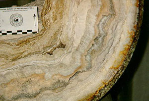
A bonanza vein at Hishikari. The right hand banded half of the vein averages over 400 g/t Au. The massive left hand half of the vein, and the enclosing country rocks, are barren, except where the latter contains banded veinlets. Image by: Mike Porter, taken during mine visit in 2005.
 Return to top
Kasuga - Kyushu, Japan ...................... Wednesday 30 March, 2005.
Kasuga is one of a group of three main deposits (the other two being, Iwato and Akeshi), which are found in the Nansatsu district of southern Kyushu, Japan and have together produced more than 27 tonnes of gold. All three have similar geologic characteristics, known as the "Nansatsu-style", more commonly referred to as high-sulphidation epithermal Au mineralisation.
Return to top
Kasuga - Kyushu, Japan ...................... Wednesday 30 March, 2005.
Kasuga is one of a group of three main deposits (the other two being, Iwato and Akeshi), which are found in the Nansatsu district of southern Kyushu, Japan and have together produced more than 27 tonnes of gold. All three have similar geologic characteristics, known as the "Nansatsu-style", more commonly referred to as high-sulphidation epithermal Au mineralisation.
The basement rocks in the Nansatsu district are dominated by Cretaceous sandstone rich trench turbidites with minor submarine basalt and chert, overlain by Tertiary-Quaternary calc-alkalic volcanic rocks which are associated with caldera development and the outflow of 5.9 to 6.4 Ma pyroclastics emplaced shortly before the mineralising event. Across the district, there was an east-ward shift with time in the locus of calc-alkaline volcanism, which includes pyroxene-hornblende, hornblende- and pyroxene-andesite flows and their pyroclastic equivalents, and tuffaceous siltstones. Hydrothermal activity displays a similar eastward younging pattern to the volcanism.
The gold mineralisation is entirely restricted to the intensely silicified rocks which form the core of these deposits. The silica core of each system is enveloped by argillic alteration that is zoned from an inner alunite-kaolinite, through to an outer smectite and/or interstratified illite/smectite interval. This argillic zone is usually less than 1 to 10 m thick and grades outward into propylitic alteration and finally into fresh country rock. The silica zone is underlain by deep alteration characterised by abundant pyrite and typically Na rich alunite, while dickite dominates over kaolinite. At depth the alunite dickite grades into a sericite-chlorite assemblage.
The principal ore minerals are enargite and electrum, with rare luzonite in the upper sections and ubiquitous and dominant pyrite throughout. Gold grades, which are intimately associated with goethite as native gold in the upper parts of the orebody, are roughly concentric, decreasing outwards. The main high grade zone contains 5 g/t Au in the western part of the pit where the fracture density is highest.
The mine produces around 10 000 tonnes per month of silica flux which contains approximately 4 g/t Au retrieved during the copper smelting process for which the flux is utilised. The reserves at the end of WW2 were approximately 1.6 Mt of ore, with around 0.8 Mt now remaining. Larger tonnages of lower grade (around 1 g/t Au) is known nearby. Historic production from Kasuga between 1929 and 1994 amounteds to some 8.8 tonnes of Au and 5.0 tonnes of Ag. While small, the deposit is a good example to illustrate many of the characteristics of high sulphidation Au-Ag mineralisation in an intensively studied district.
Return to top
Martabe - Sumatra, Indonesia ....... (Thurs. 31 March travelling) ...... Friday 1 & Saturday 2 April, 2005.
The Martabe group of gold deposits, including Purnama Pit 1 (Purnama Dalam Zone), Purnama Timur, Barani (Pelangi), Horas, Horas Barat, Ramba Joring (Baskara), Tor Uluala (Kejora), Tor Uluala Barat, Uluala Hulu Extension and Uluala Hulu, define a more than 7 km long, by ~1km wide mineralised corridor near the town of Sibolga in the North Sumatra Province of Indonesia, on the west coast of Sumatra Island, some 200 km south of Medan (#Location: 1° 31' 21"S, 99° 4' 3" E).
The main Pit 1 exploits the Purnama Dalam Zone and adjoining Purnama Timur deposit over a 1 km NNW-SSE trend. The Barani Pit is just over 1 km to the SE, while the Horas and Horas Barat deposits are just under 2 km SSE of the Barat Pit. The Ramba Joring Pit is just over 1 km NNE of the Main Pit 1. The Tor Uluala, Tor Uluala Barat, Uluala Extension and Uluala Hulu deposits are ~2 km north, ~2.2 km NNW, 2.5 km NNE and 3.5 km NNE of the main Pit 1.
These deposits comprise high sulphidation epithermal mineralisation within Tertiary volcanics and sediments proximal to a splay of the regional scale, NNW- to NW-trending, Great Sumatra Fault Complex. Wrench tectonics imposed by the oblique subduction of the Indo-Australian plate to the SW below the Eurasian plate of which Sumatra is part, resulted in episodic fault activity, pulses of high level magmatism, multistage phreatomagmatic breccias, flow dome complexes, hydrothermal alteration and gold mineralisation. Local structure reflects the regional dextral strike slip tectonics as NW to NNW fault sets, and related NE trending en echelon conjugate extensional faults to the east which together have promoted and localised fluid flow to produce zones of intense silicification and veining. A third, east-west set of contractional faults with a reverse component is also evident.
The geology of the Martabe district is divided into two domains by the NW to NNW trending Purnama Fault. To the SW are little disturbed and weakly altered mudstones, siltstones, sandstones and basaltic to andesitic lavas. In contrast, to the NE a comparable sequence of lithologies, with the addition of volcanic breccias, have been subjected to a complex series of multiphase magmatic, phreatomagmatic and hydrothermal influences.
The oldest rocks in the Martabe area are Palaeozoic meta-sedimentary rocks of the Tapanuli Group. The eastern part of the area is dominated by Triassic granites (correlated with the Sibolga granite batholith to the northwest), which have both intrusive and fault contacts with the older rocks.
The oldest of the overlying Tertiary units is the Barus Formation, which mostly comprises sediments, mainly conglomerates and sandstones, with minor siltstones and shales, that underlie much of the Martabe area. The Barus Formation sediments are overlain by the Miocene age Angkola Volcanics, a series of basaltic and andesitic lavas and breccias. The porphyritic andesite and volcanic breccia are significant host rocks to mineralisation.
A Late Tertiary dacitic dome complex, was emplaced along the faulted western margin of the granites. This complex comprises an early series of fault-controlled phreatomagmatic intrusive breccias followed by an intrusive dacitic flow dome complex that includes a dacitic porphyry, which is also a significant host rock, and a hornblende andesite, which is a late-stage intrusive and is generally unmineralised (except at Ramba Joring). Multiple diatreme facies overprinting each other are regarded as being coeval with the early dacitic intrusives in the north, while a second phase of multistage phreatomagmatic breccias have partially destroyed sedimentary sequences and define a concentric pattern around the late porphyritic hornblende andesite intrusive body.
Overlying all of these rocks is the Quaternary Toba Tuff, which forms a prominent plateau to the north of Martabe but is restricted to small erosional remnants in the Martabe area.
Mineralisation is dominantly hosted in steeply west dipping to subvertical breccia units and structural zones within the andesite host sequence that are presumed to be conduits for the hydrothermal fluids. The high sulphidation epithermal mineralisation followed extreme acid sulphate leaching of the wall rocks. This early stage leaching, which was focussed on the major structures, produced an advanced argillic assemblage with vuggy to massive silica, surrounded by a silica/dickite/alunite advanced argillic alteration envelope, grading outwards into silica-illite and peripheral kaolinite-illite argillic zones. The silicification (or removal of other minerals to leave silica) produced a vuggy, porous, brittle rock subject to fracturing which subsequently channelled mineralising fluids such that gold grades are directly proportional to the percentage of silica.
Individual deposits are composed of multiple mineralised zones, e.g., at Tor Uluala, mineralised zones are distributed over a strike length of over 1.2 kilometres, many of which outcrop at surface. This mineralisation is open at depth and is dominantly hosted in steeply west dipping to subvertical breccia units within an andesite/dacite host sequence.
Mineralisation within the corridor comprises:
i) an early weak (0.1 to 0.5 g/t Au) silica-pyrite phase immediately following the acid sulphate leaching;
ii) a low sulphidation phase of colloform banded chalcedonic silica veins with quartz and bladed carbonate 'boiling' textures with low (0.1 to 1 g/t Au);
iii) the main high sulphidation stage enargite/luzonite assemblage with associated covellite, native sulphur, pyrite, bismuthinite barite and marcasite in fractures and vugs that are mostly oxidised. In this latter stage, where un-oxidised, gold occurs as free grains and in enargite, while silver is in enargite/luzonite and as proustite/pyrargyrite inclusions in bismuthinite. The best gold is late in the hydrothermal event in late stage fracturing and crackle type brecciation of the silicified rocks marginal to the late clay-altered diatreme breccia;
iv) oxidation which is highly irregular and controlled by fracturing, has affected most of the fracture controlled mineralisation but does not seem to have resulted in any supergene upgrading. Minor to strong oxidation extending to depths greater than 100 m in places at Tor Uluala, although fresh sulphides can also be observed close to surface. While oxidation has not resulted in supergene upgrading, it has improved the metallurgical recovery of the refractory primary sulphide mineralisation.
At the end of 2003 the quoted resource at the Purnama deposit alone, amounted to 51.9 Mt @ 1.9 g/t Au for 98 tonnes (3.15 Moz) of contained gold (Newmont, 2004).
Resources (predominantly oxides) and reserves (all oxides), in Sept 2011 at a 0.5 g/t Au cut-off (G-Resources, 2011) were:
Proved + probable reserve at Pit 1, Barani and Ramba Joring - 45.5 Mt @ 2.1 g/t Au, 23.0 g/t Ag
Measured + indicated + inferred resources at Purnama, Purnama Timur, Barani, Ramba Joring, Tor Uluala and Uluala Hulu -
165.2 Mt @ 1.4 g/t Au, 13.6 g/t Ag (for 232 t, or 7.46 Moz of contained Au).
Measured+indicated+inferred resources (dominantly oxides) by deposit, in August 2012, at a 0.5 g/t Au cut-off (G-Resources, 2012) were:
Purnama - 82.04 Mt @ 1.7 g/t Au, 22 g/t Ag;
Purnama Timur - 4.97 Mt @ 1.5 g/t Au, 13.2 g/t Ag;
Ramba Joring - 38.35 Mt @ 1.0 g/t Au, 4.1 g/t Ag;
Barani - 16.9 Mt @ 1.2 g/t Au, 3.2 g/t Ag;
Tor Uluala - 31.5 Mt @ 0.9 g/t Au, 7.7 g/t Ag (inferred resources only);
Horas - 15.7 Mt @ 0.8 g/t Au, 1.7 g/t Ag (inferred resources only);
Uluala Hulu - 1.26 Mt @ 2.0 g/t Au, 24.0 g/t Ag (inferred resources only);
TOTAL - 190.72 Mt @ 1.31 g/t Au, 12.5 g/t Ag, for 250 t (8.05 Moz) of contained gold;
Return to top
Lihir - Papua New Guinea ........... (Sun. 3 & Mon. 4 April. travelling) .......... Tuesday 5 April, 2005.
The Ladolam gold mine lies within the Luise Caldera, located on the eastern side of the north-south elongated, 20 x 12 km, Lihir, or Aniolam Island within the Tabar-Lihir-Feni-Tanga chain of islands northeast of New Ireland.
(Location: 3° 7' 42"S, 152° 38' 6"E).
Indications of gold mineralisation associated with hydrothermal alteration and thermal activity were first detected during geological mapping conducted by the Australian Bureau of Mineral Resources between 1969 and 1974. Based on these observations, Kennecott Exploration Australia in joint venture with Niugini Mining Limited in 1982 sampled the locations indicated, resulting in a rock chip sample in Luise Harbour averaging 1.7 g/t Au. This resulted in an application for an Exploration lisence being lodged and granted, also in 1982, and a drilling program commencing in 1983. By the end of 1984 the presence of a large gold resource had been confirmed. This work had concentrated on the Luise Harbour and adjacent Lienetz area. Further sampling between 1985 and 1987 identified gold in the neighbouring Ladolam Creek with follow-up drilling intersecting the Minifie deposit. Further drilling defined several other adjacent and partly overlapping deposits, known as the Camp and Kapit areas. In 1988, RTZ plc (now Rio Tinto) acquired Kennecott from BP Minerals America and took over as the joint venture partner with Niugini Mining Limited. In June 1995, Lihir Gold Limited (LGL) was incorporated in PNG for the purpose of acquiring formal ownership of the project from the Lihir Joint Venture. This entity was owned by Rio Tinto, Niugini Mining and the Lihir Islanders. Mining Leases were granted in 1995. Construction began in the same year, and by 1997 the processing plant at the Putput site was complete with the first gold pour on 25 May 1997. Rio Tinto sold their remaining interest in 2005. In 2010, Lihir Gold Limited was merged into Newcrest Mining. Production increased from 7.24 to over >20
tonnes of gold per annum between 1997 and 2008, and has varied between 18.7 and 29.7 t per annum over the period from then to 2020, for a total production of 504.2 tonnes of gold since mining commenced in 1997 to June 2020. Average recovery between 1997 and 2020 has been 83.4%
Lihir is a major bulk gold deposit with mineralisation represented by an earlier un-economic porphyry stage, and a later, overprinting low sulphidation advanced argillic phase that accompanied the introduction of the bulk of the gold mineralisation. The three main orebodies, from south to north, Minifie, Lienitz and Kapit (the latter two connected by the Link zone) are located within a generally north-south elongated area inside the breached 5.5 x 3.5 km Luise Caldera on the east coast of Lihir Island. All fall within a 1.5 to 2 km radius of the centre of the caldera.
Minifie has a mushroom shape with plan dimensions of the order of 700 x 400 m with mineralisation extending from 50 m above to 150 m below sea level. Shallow-level refractory sulphide ore is associated with pervasive adularia-sulphide alteration, and had a concave, blanket-like geometry. Beneath the refractory sulphide mineralisation is quartz-calcite vein stockwork material.
Lienitz is 600 x 300 m in plan and is mineralised from 140 m above to 250 m below sea level, although the bulk of the ore is from sea level to 200 m below. It is separated from Minifie by unmineralised, propylitically-altered igneous units and breccias.
Kapitz is located between Lienetz and Luise Harbour to the east, and is ~500 m due north of the western limit of
Lienetz. It is linked to Lienetz by a sub-horizontal zone of low-grade mineralisation, generally carrying <2.0 g/t Au, that is up to 100 m in thickness, and comprises a funnel-shaped zone associated with adularia-pyrite alteration and open-space breccias.
The smaller Coastal zone has a NW trend, and is moderately to steeply NE dipping. It is located immediately NE of Lienitz extending to the shore of Luise Harbour. Mineralisation is hosted within leached, vuggy breccias as well as more discrete calcite-quartz-pyrite-anhydrite vein/breccias. This deposit has remained poorly drilled due to its proximity to Luise Harbour and to the apparent relatively small and narrow nature of the mineralised zones.
Lihir Island is one of a series of four volcanic island groups which rise from a submarine platform and form a chain roughly parallel to and 50 km to the north-east of New Ireland in Papua New Guinea. This chain is also parallel to and 100 km south-west of the Kilinailau Trench where the Pacific plate subducted below the Melanesian Arc which is peripheral to the Australian Plate until the Mid Miocene. The magmatic arc of the Tabar-Lihir-Feni-Tanga chain of islands however, is apparently related to subduction below the New Britain Trench to the south, exploiting a pre-existing crustal weakness from the earlier subduction, and/or a transform fault associated with extension on the Manus Spreading Centre.
The 3 to 1 Ma Luise Caldera occupies the youngest of several Miocene to Holocene alkaline volcanoes developed on the island. The oldest rocks on the island comprise 350 m of Pliocene to Miocene mafic lavas and volcaniclastics of the Londolovit Block on the northern tip, while a NE-SW elongated, unconformably overlying and partly fault bounded block of Pliocene to Pleistocene mafic lavas, agglomerates and lahars around 500 m thick, the Wurtol Wedge adjoins, the Londolovit Block and stretches across the island to the west coast. The Londolovit Block and Wurtol Wedge probably represent portions of a deeply eroded Late Miocene to Pliocene volcano. Sub-economic gold with associated potassic, phyllic and argillic alteration is hosted by altered intermediate volcanics and intrusives. The southern part of the island is occupied by the Pliocene to Pleistocene Kinami Volcano lavas, pyroclastics, breccias and derivative epiclastics. This volcano has associated phyllic and argillic alteration, which grades into potassic zones at depth, which in turn pass out into propylitic zones. Low grade gold accompanies the phyllic alteration. The Pleistocene Huniho Volcano, which has a number of satellite cones and craters makes up the north-western segment of the island with tephras and lahars overlying mafic lavas. The late 5.5 x 3.5 km Luise Caldera is the remnants of a volcanic edifice on the central east coast, north of the Kinamo volcano and east of the Wurtol Wedge. The associated volcanics include trachy-basaltic lavas, pyroclastics and breccias. All three of the remnant volcanic centres have undergone some form of seaward collapse, particularly the most recent, the Luise volcano. Raised coral reefs fringe most of the island, but are absent in Luise Harbour, suggesting they predate the caldera flooding event.
Volcanic rocks predominate in the upper parts of the ore zones of the Luise Caldera, and the margins of the system, and are underlain by intrusives. The host volcanic sequence occupies most of the floor of the Luise Caldera and comprises intermediate (latitic, andesitic and trachytic) lavas, tuffs and volcanic breccias. These extrusives are intruded by a series of fine to medium grained, quartz poor but silica saturated monzonitic to monzodioritic porphyries ranging from pyroxene microdiorite to biotite syenite and some andesite porphyry.
Intrusion-related potassic alteration occurred in the period 0.917 to 0.342 Ma, while the epithermal gold mineralisation is dated at 0.336 Ma, possibly continuing to 0.1 Ma, although the geothermal system is presently active. While the Luise Caldera trends elongate NNE, it is cut by north-south structures associated with the deep fractures that are interpreted to localise the magmatism of Lihir Island. NW-trending fractures are also evident and host the NE-dipping Minifie mineralisation. The Luise volcano is interpreted to have collapsed sideways at about 0.34 Ma. NE-dipping listric-style faults are interpreted to have developed within the remaining underlying part of the edifice. This failure removed about 1 km from above an active porphyry Cu-Au deposit. In doing so, it is believed to have removed the confining pressure and allowed epithermal fluids to escape up the listric faults produced during the collapse, and as such initiated development of the epithermal mineralisation.
Mineralisation is coincident with a NNE trending zone of hydrothermally altered volcanics and breccias intruded at depth by porphyries. Three stages of alteration have been identified,
i). an early porphyry style accompanied by low grade Cu-Au-Mo mineralisation at depth, with a potassic core (mostly phlogopitic biotite-anhydrite with lesser orthoclase, magnetite with pyrite, chalcopyrite and molybdenite) and a peripheral propylitic phase (chlorite ±amphibole ±albite ±epidote ±calcite ±magnetite);
ii). A transitional zone, which forms the bulk of the ore at Minifie, characterised by pervasive adularia ±illite and fine grained, refractory auriferous pyrite within extensive shallow hydrothermal breccias located above biotite altered porphyritic stocks, and grading abruptly downward into sub-economic anhydrite-K feldspar ±pyrite alteration of the porphyry system; and
iii). a younger, overprinting and shallower low sulphidation epithermal style as in the Lienetz area, comprising advanced argillic (alunite ±opaline silica ±kaolinite ±sulphur), argillic (kaolinite ±smectite ±illite) and phyllic (illite ±K-feldspar ±silica). Alteration generally forms a horizontal layering, with porphyry style potassic and propylitic assemblages at depth, grading up through phyllic to epithermal argillic and advanced argillic phases nearer the surface.
Alunite and opal fill veins and stockworks near the surface, grade to quartz and adularia at intermediate depths, underlain by anhydrite and carbonate. Sulphides and gold mineralisation generally mimic the horizontal alteration pattern, although some follows steep 'feeder' fractures. The horizontal zonation represents a surface oxidation regime, related to mixing with ground water, passing down progressively into argillaceous altered and silica clay, through to a boiling layer and then the anhydrite sealed zone. Grades are best from the silica-clay to the boiling zones. Gold is predominantly fine grained and contained within pyrite and marcasite. The overall sulphide or reactive sulphur content averages 6%. Geothermal activity is still taking place.
Mineral Resources and Ore Reserves at Lihir as of January 2004 (Newcrest Annual Report, 2004) were:
Total Identified Mineral Resource at a 1.5 g/t Au cut-off - 442.5 Mt @ 3.14 g/t Au for 1390 tonnes of contained gold.
Proved + probable reserves were - 163.5 Mt @ 3.88 g/t Au for 635 tonnes of contained gold.
Mineral Resources and Ore Reserves at Lihir in August 2011 (Newcrest Mining website, 2012) were:
Measured + Indicated + Inferred Mineral Resource - 830 Mt @ 2.1 g/t Au for 1745 tonnes of contained gold.
Proved + Probable Reserves - 400 Mt @ 2.4 g/t Au for 960 tonnes of contained gold.
NOTE: Mineral Resources are inclusive of Ore Reserves.
Remaining Mineral Resources and Ore Reserves at 30 June 2022 (Newcrest Mining Annual Mineral Resources and Ore Reserves Statement, August 2022) were:
Mineral Resources
Open Pit Measured + Indicated Mineral Resource - 510 Mt @ 2.3 g/t Au;
Open Pit Inferred Mineral Resource - 67 Mt @ 2.3 g/t Au;
Stockpile Measured + Indicated Mineral Resource - 72 Mt @ 1.8 g/t Au;
TOTAL Mineral Resource - 649 Mt @ 2.25 g/t Au for 1456 tonnes of contained gold.
Ore Reserves
Open Pit Proved + Probable Ore Reserves - 230 Mt @ 2.4 g/t Au;
NOTE: Mineral Resources are inclusive of Ore Reserves.
As of July 2023, the Lihir operation was owned by Newcrest Mining Limited.
Some of the information above has been drawn from "Gleeson, K., Butt, S., O’Callaghan, J. and Jones, C., June 2020 - Lihir Operations, Aniolam Island, Papua New Guinea; an NI 43-101 Technical Report prepared by Newcrest Mining Limited, 197p."
Return to top
Hidden Valley - Papua New Guinea ................. Wednesday 6 April, 2005.
The Hidden Valley low sulphidation carbonate-base metal-gold epithermal deposits are within the Morobe Goldfield, in the Morobe Province of Papua New Guinea, 210 km NNW of Port Moresby. The total production from the Goldfield to 1975, which also includes the historic Wau and Edie Creek epithermal deposits and the extensive Bulolo placer accumulations, amounted to 115 tonnes of Au, of which approximately 15% was from lodes, the remainder being from alluvial operations.
The Morobe Goldfield lies within the Highlands Fold Belt of the New Guinea Orogenic Province, situated between the overthrust Papuan Ultramafic Belt to the north-east and the Neogene sediment filled Aure Trough to the south-west. The basement in the district, the Cretaceous Owen Stanley Metamorphics (which include blue-grey graphitic slate, chloritic and sericitic schist and phyllites, with minor quartzite and marble), is intruded by the 14.3 Ma Miocene Morobe Granodiorite Batholith. These are overlain by a Pliocene sequence that includes, the Bulolo Ignimbrite which is several hundred metres thick and dips at 40 to 65°E, and the Otibanda Formation comprising 700 m of poorly sorted auriferous conglomerate and sandstone with minor reworked tuff and ignimbrite near the base, and the Pliocene (3.8 to 3.4 Ma) intrusive dacite to andesite porphyry of the Edie Porphyry which has strongly altered (silica-sericite-pyrite) the surrounding metamorphics. These are all cut by the Namie Breccia of the Wau Maar complex which is generally coarse and poorly sorted and is believed to be of subaerial phreatomagmatic origin. Some of the Edie dacite porphyries in the district are present as domes emplaced during the formation of the maar and generally found along the ring fault. All of these are overlain in part by Pleistocene fluvial and fluvioglacial sediments. A major NNW trending, 10 km long, east dipping fault zone, the Escarpment Fault cuts most rocks up to the beginning of Maar Formation. Exposures of the fault show fault gouge, silicification, pyritisation, as well as hosting intrusions of Edie Porphyry and hydrothermal breccias similar to the Namie Breccia.
All of these rocks lie within the down faulted, NNW-SSE trending Bulolo Graben/Wau Basin, between two blocks of Morobe Granite. This graben is extensional, with listric faults, and some structures that, at stages, were subjected to reverse movement. These graben faults have influenced the distribution of breccia and intrusives and are believed to be in part reactivated older structures. It would seem that the graben was active prior to, during and probably after the Pliocene magmatism and mineralisation. Primary gold occurs in a number of forms in the district. These include i). Lodes and Veins - stringers and veins of quartz with gold on the margin of the Morobe Granodiorite, mainly in the Kaindi metamorphics, ii). mesothermal gold associated with the Pliocene dacite-andesite porphyries and iii). the bulk of the gold which is epithermal and hosted by rocks related to the Wau Maar.
The extensive vertical relief in the Morobe district and the graben preserves and exposes varying styles of intrusion-related low sulphidation epithermal gold mineralisation. At the deepest levels (e.g., the Hamata deposit), massive quartz-sulphide-gold style mineralisation is associated with magnetite-K feldspar porphyry style alteration; at mid-levels (e.g., Wau and Hidden Valley) carbonate-base metal-gold mineralisation occurs, while bonanza gold-grade epithermal quartz-Au-Ag mineralisation (e.g., Edie Creek) crops out at the highest topographic level. Most deposits display overprinting relationships (e.g., Edie Creek), while the Kerimenge prospect hosts three low sulphidation mineralisation styles, variably telescoped over a 250 m vertical extent.
In the Hidden Valley project area the Morobe Granodiorite batholith (locally a coarse grained monzogranite) is flanked by fine metasediments of the Owen Stanley Metamorphics. Both are cut by narrow dykes and small stocks of Pliocene porphyry (correlated with the Edie Porphyry) ranging from hornblende-biotite to feldspar-quartz porphyries. A number of commonly argillic altered and gold anomalous breccias are known, including both hydrothermal and overprinting structural breccias.
The Hidden Valley deposit area is dominated by a series of post Miocene faults controlling the gold mineralisation, including an early north trending set and the main NW faulting. The NW trending, 30 to 35° NE dipping Hidden Valley Fault, with its associated breccia, is the most important structure in the deposit area, forming a planar structural base underlying the main mineralisation. The main Hidden Valley Kaveroi orebody is broadly tabular, up to 100 m thick, and is localised immediately above and parallel to the Hidden Valley Fault.
Alteration is variable, ranging from pervasive to intense, accompanying veins and breccias. All rocks exhibit propylitisation (chlorite-epidote-pyrite), from pervasive to discrete alteration associated with structures. Argillic alteration (kaolinite-carbonate and occasionally smectite) is associated with breccias and veins. Adularia is present in carbonate veins, while an envelope of phyllic alteration with an illite-leucoxene-quartz assemblage commonly surrounds these veins, joints and breccias.
Gold and silver mineralisation is found within veins that occur within structurally controlled stockworks within the granodiorite on the hangingwall of the Hidden Valley Fault in three vein-alteration suites, as follows: i). quartz veins with weak pyrite-chlorite-epidote propylitic alteration, which are generally barren, and are thicker and more prevalent in the metamorphics than in the granodiorite; ii). chlorite veins with hematite-quartz-carbonate-pyrite, which are mainly found as either larger composite veins or a microveins in stockworks in the granodiorite, above and below the Hidden Valley Fault, often associated with strong propylitic alteration and are only rarely gold mineralised, and iii). carbonate veins which contain the main gold ore, and were developed in three pulses, namely a). irregular carbonate-quartz-adularia veinlets which are not strongly mineralised; b). carbonate-adularia-mixed sulphides-gold as a second pulse, occurring as carbonate veining (often with collorm banding) enveloped by quartz-adularia-sulphide selvages, from which a 4.15 Ma date has been obtained from adularia, with more sulphides (pyrite, sphalerite, galena and chalcopyrite) and rare visible gold, and c). carbonate-kutnahorite-gold representing a third phase which has visible gold and tetrahedrite infilling corroded earlier sulphides. Gold correlates best with the carbonate content of these veins rather than with adularia or base metal sulphides.
The Hamata deposit is hosted within the Morobe granodiorite, which it is cut by two types of andesite porphyry dyke, characterised by feldspar and hornblende phenocrysts respectively, and by dacite porphyry (correlated with the Edie Porphyry). The Edie Porphyry occurs as a larger, unaltered body to the west, and a series of altered, smaller dykes within the ore zone. Primary gold mineralisation at Hamata is related, and proximal, to the altered Edie Porphyry intrusions. It occurs in at least three, NE-striking and 45 to 50°SE dipping, sub-parallel zones (Masi, Lower and Eastern) that are each up to 50 m thick. They are composed of low density and diffuse zones of quartz-pyrite veining within K feldspar-sericite altered granodiorite, although at the upper contacts of each zone, 3 to 4 m wide reefs of pyrite-hematite±magnetite-quartz veins are well developed, and contain the main gold ore zones. Each reef zone contains one or more of these ore zones, with strike lengths of up to 600 m, down-dip extents of 200 to 300 m and thicknesses of 1 to 10 m. Three stages of mineralisation are recognised: Stage 1 - semi-regional thin magnetite-hematite-pyrite veins with K feldspar-sericite selvages; Stage 2 - coarse pyrite-hematite-magnetite-quartz fracture fill with sericite alteration and the bulk of the gold mineralisation, occurring as non-refractory 20 to 30 µm blebs in pyrite; and Stage 3 - shear veins of quartz-pyrite-arsenopyrite-marcasite with sericite and clay alteration, and only low, refractory gold.
The Hidden Valley Mine consists of the Hidden Valley Kaveroi and Hamata open pits, which are ~6 km apart, and an ore processing facility, situated in steep, heavily forested, mountainous terrain.
At the end of 2003 the total mineral resource at Hidden Valley and the nearby Hamata and Kerimenge prospects was: 53.3 Mt @ 2.7 g/t Au, 47.1 g/t Ag for 144 tonnes (4.72 Moz) of gold, with 1730 tonnes (55.7 Moz) of silver.
Reserves and resource at Hidden Valley Kaveroi as of June 2010 (Morobe JV, Newcrest Mining website, 2012) were:
Total Measured + Indicated + Inferred Mineral Resource - 96 Mt @ 1.65 g/t Au, 33 g/t Ag for 158 tonnes (5.1 Moz) of contained gold;
Proved + Probable Reserves (a subset of the resources) - 55.7 Mt @ 1.82 g/t Au, 35.6 g/t Ag for 101 tonnes (3.26 Moz) of contained gold.
Reserves and resource at Hamata as of August 2011 (Morobe JV, Newcrest Mining website, 2012) were:
Total Measured + Indicated + Inferred Mineral Resource - 6.66 Mt @ 2.4 g/t Au, for 15.9 tonnes (0.5 Moz) of contained gold;
Proved + Probable Reserves (a subset of the resources) - 5.6 Mt @ 2.12 g/t Au for 11.9 tonnes (0.38 Moz) of contained gold.
The operation is controlled by the Morobe Mining Joint Venture (Harmony 50%, Newcrest 50%).
Return to top
Wafi Gold & Golpu Porphyry - Papua New Guinea ................. Wednesday 6 April, 2005.
The Wafi gold deposits and the related Golpu porphyry copper-gold deposit around 1 km to the north-east, are both parts of a complex hydrothermal system comprising porphyry, as well as high and low sulphidation Cu-Au mineralisation, often with overprinting alteration relationships. These deposits fall within the Morobe Goldfield in Morobe Province, Papua New Guinea, approximately 60 km south-west of the port of Lae and 70 km NNW of the Hidden Valley project. (#Location: 6° 53'S, 146° 27'E).
Gold was originally reported from the Wafi River from the 1930s. A 1977 geochemical sampling program conducted in the area by CRAE (no gold assays), part of a program that led to the discovery of the nearby Wamum porphyry copper, returned low level base metal anomalies which were followed up in 1977. During this follow-up program, a pyritic float boulder was identified that assayed 22 g/t Au, 0.57% Pb, 89 g/t Ag. Upstream follow up led to the recognition of altered pyritic volcanics of the Wafi high sulphidation system. The Wafi gold zones were subsequently delineated, but due to the low grade and refractory nature of the gold, the area was joint ventured the property to Elders in 1988. The JV however required Elders to drill 4 conceptual holes based on a consultants structural and fluid flow model to test the source of the high sulphidation fluid. The third of these holes in 1989, intersected 263 m @ 1.86% Cu, 0.27 g/t Au. Elders were subsequently acquired by another party who sold their mineral holdings, which were bought back by CRA. In 2002 the property was taken over by Aurora Gold, then Abelle Ltd who have subsequently been bought by Harmony, the current holder whose principal interest is gold.
The Wafi project lies within the Wau Basin, the north-south structural corridor that divides the western and eastern segments of the New guinea Orogen. One of the most intense structures that constitute this corridor, the Wafi Structure, localises the hydrothermal system at Wafi and also produces a dextral offset of the Ramu Fault to the north.
The country rock to the mineralised system comprises metasediments of the lower Jurassic to Cretaceous Owen Stanley Metamorphics derived from a sequence of argillite, phyllite, metagreywacke, conglomerate and schist, subsequently metamorphosed to lower greenschist facies and strongly deformed into a series of tight NE trending folds. In the project area, the dominant lithologies are clast supported gabbro-rich conglomerate, sandstone, siltstone and shale, with fine to medium grained sandstones. These have been intruded by the middle Miocene (12.9 ±2Ma) Morobe Granodiorite and the 14 Ma Golpu diorite porphyry, and are unconformably overlain by the Pliocene Babwaf Conglomerate.
The mineralised system is reflected at surface by a zone of disseminated pyrite surrounding areas of higher gold content within an advanced argillic, quartz-alunite lithocap. Mineralisation and alteration are associated with a Miocene to Pliocene intrusive complex whose influence is spread over an area of 9 sq. km, centred on the Miocene Golpu diorite to dacite porphyry plug and a late stage overprinting diatreme breccia.
The 800 x 400 m maar-diatreme breccia pipe has steep-dipping margins and comprises a polymictic milled matrix breccia. Several phases of xenolith bearing Wafi dacite porphyry intrusions cut the milled matrix breccia about the pipe margins, as possible endogenous domes. The late-mineral Heking Andesite cuts the dacite porphyry. Potassic alteration within the concealed Golpu diorite porphyry has been dated at 14 Ma and is cut by the diatreme breccia, which is inferred to be associated with the later intrusion event leading to the epithermal gold mineralisation, dated of 13 Ma from alunite within the high sulphidation alteration
The Golpu porphyry copper-gold deposit is associated with a near vertical diorite stock with a diameter of 300 m in its upper sections, contracting to 150 m some 650 m lower. It has a vertical extent in excess of 1200 m and is bounded in part by two NE striking post mineralisation faults. The porphyry system is vertically zoned, with the upper part, below the pyritic advanced argillic quartz-alunite lithocap, being overprinted by a high sulphidation epithermal event that has produced an enargite-covellite-tennantite assemblage. The high sulphidation zone has a well marked base, below which covellite development is associated with a zone of phyllic (silica-sericite-pyrite) alteration, overprinting a lower mass of chalcopyrite-bornite mineralisation at depth accompanied by a core of potassic alteration (biotite-quartz-magnetite±Kfeldspar). Immediately outside of the porphyry contact a 5 to 30 m wide shell of porphyry related stockwork A and D style veining is developed within the meta-sediments (with grades of up to 1% Cu, 2 g/t Au), grading out into propylitic alteration (inner actinolite-epidote and outer epidote-chlorite) and a molybdenum anomalous outer halo. The upper part of the system, above the advanced argillic layer, has a leached cap overlying a thin, rich (eg., 4 m @ 7% Cu) supergene chalcocite-digenite blanket.
The characteristics of the deposit (from Williamson and Hancock, 2005) are:
i). the lack of any surface geochemical manifestations of the porphyry within the barren quartz-alunite cap;
ii). supergene copper enrichment grades of 2.5 to 3.5% Cu which extend from below the base of oxidation at 100 m below surface to 250 m depth, as a several metre thick high-grade zone of chalcocite-diginite, underlain by transition zone silica-alunite-altered porphyry containing covellite-enargite-pyrite (chalcocite-tennantite). In this zone the porphyry Cu-Au mineralisation is overprinted by high sulphidation alteration and remobilised mineralisation;
iii). the upper portion of hypogene phyllic-argillic altered porphyry extending to a depth of 350 m yields grades of 1 to 2% Cu and 0.3 to 0.8 g/t Au in association with pyrite-covellite;
iv). at the deepest levels, where the potassic alteration is preserved and pyrite-chalcopyrite±gold±bornite±molybdenite ores have grades of 1 to 3% Cu and 1 to 2.5 g/t Au, although much of the pyrite is interpreted to have been introduced during the later high sulphidation event. Native gold occurs as minute inclusions within chalcopyrite and bornite.
In mid 2008 the identified mineral resource at Golpu was quoted at 163.1 Mt @ 1.08% Cu, 0.13% Mo, 0.57 g/t Au for 92.2 tonnes (2.96 Moz) of gold (Harmony Gold, website).
Recent drilling (2009-10) has indicated extensions of the main Golpu deposit to the northwest and at depth with intersections of 379 m @ 0.88g/t Au and 1.05% Cu from 1062 m (including: 156 m @ 1.09g/t Au and 1.48% Cu from 1149 m), and 528 m @ 0.70g/t Au and 1.41% Cu from 551 m (including: 187 m @ 1.57g/t Au and 3.16% Cu from 892 m). These and other intersections suggest an exploration target in the range of 500 to 800 Mt at grades of between 0.7% and 1.1% Cu and 0.5 to 0.7g/t Au, including the current resource (Harmony Gold press release, April 2010).
Reserves and resources at the end of August were (Newcrest Mining ASX Release, 29 August, 2012):
Indicated Resource - 810 Mt @ 0.92% Cu, 0.64 g/t Au, 1.1 g/t Ag;
Inferred Resource - 190 Mt @ 0.80% Cu, 0.61 g/t Au, 1.0 g/t Ag;
TOTAL Resource - 1000 Mt @ 0.90% Cu, 0.63 g/t Au, 1.1 g/t Ag;
Probable Reserve - 450 Mt @ 1.2% Cu, 0.86 g/t Au, 1.4 g/t Ag.
The Wafi Gold deposit comprises four key zones, (Zone A, Zone B, the Link Zone and the Western Zone) distributed around a core dacitic vent. Two breccias are the centre of interest for the gold mineralisation. The first is limited in extent and is found in the east and south-east of the complex and is fragment rich. The second in the west is a diatreme complex with surface dimensions of around 500 x 1000 m, narrowing drastically with depth to a wine glass shape. It is matrix supported and has milled shale, siltstone and feldspar porphyritic diorite clasts, and a matrix of rock flour, lithic fragments, feldspar and rare quartz crystals. Intense alteration makes the recognition of primary textures difficult, although accretionary lapilli have been recognised. The unmineralised Pliocene Babwaf Conglomerate overlies both the altered and mineralised Owen Stanley Metamorphics, intrusive feldspar porphyritic diorite of the Golpu porphyry and the diatreme. The diatreme breccias which host the Wafi gold orebodies are younger than the main feldspar porphyritic diorite and the potassic and phyllic alteration and associated Golpu porphyry copper, gold and molybdenum mineralisation. The main gold ore occurs with disseminated sulphides within the breccias or as veins in the porphyry and metamorphics. A 2.3 sq km surface zone of pyrite alteration centred on the main diatreme, and extending out into the surrounding Owen Stanley Metamorphics, is overlain by a soil gold anomaly of >0.2 g/t Au and encloses the gold rich bodies that comprise the gold resource. Alteration is concentric from a central advanced argillic core surrounded by an acid-argillic zone of quartz-kaolinite (with up to >75% silica) and then to irregular zones with phyllic and argillic assemblages and finally to propylitic alteration of the surrounding country rock. Gold, with rare exceptions, is submicroscopic and occurs in advanced argillic and phyllic alteration zones.
The high sulphidation gold event alteration overprints the Golpu porphyry style alteration and mineralisation, with the diatreme carrying fragments of the earlier porphyry alteration. The high sulphidation event has been interpreted to have remobilised pre-existing porphyry-related copper from the phyllic-argillic altered upper porphyry and deposited this as zoned enargite-tennantite-covellite-chalcopyrite mineralisation, while most gold was introduced in association with pyrite of the high sulphidation event.
The low sulphidation Link Zone, which occurs on the diatreme margin, between and below the Zones A and B high sulphidation gold mineralisation, is characterised by veins of mainly of pyrite with lesser quartz (quartz-sulphide-gold style), which are overprinted by more than one generation of pyrite-sphalerite-galena-carbonate veins (carbonate-base metal-gold style). Selective sampling sows the gold in this zone is related to the arsenian pyrite of the quartz-sulphide style veins, while the multi-stage low-arsenic carbonate-base metal veins contribution to the gold grade is insignificant.
In mid 2004 the identified mineral resource at Wafi Gold was quoted at 109.6 Mt @ 1.85 g/t Au for 202.5 tonnes (6.51 Moz) of gold (Harmony Gold, website).
Reserves and resources at the end of August were (Newcrest Mining ASX Release, 29 August, 2012):
Indicated Resource - 110 Mt @ 1.7 g/t Au, 3.6 g/t Ag;
Inferred Resource - 23 Mt @ 1.3 g/t Au, 2.5 g/t Ag;
TOTAL Resource - 133 Mt @ 1.56 g/t Au, 3.4 g/t Ag, containing 207 t of gold.
The project is controlled by the Morobe Mining Joint Venture (Harmony 50%, Newcrest 50%).
Return to top
Pajingo - Queensland, Australia ........... (Thurs. 7 travelling) ...... Friday 8 April, 2005.
The Pajingo mine has been largely based on the Vera-Nancy group of adularia-sericite, low sulphidation, high grade gold-silver orebodies, located some 150 km SSW of the city of Townsville and 53 km south of Charters Towers, in north Queensland, Australia. Other veins include Scott, Cindy, Steph, Camembert and Lynne, which with Vera and Nancy, which are in the centre of the trend, are distributed over a NW-SE strike length of ~6.5 km. These deposits form a zoone that is exposed to the north and plunges gently to the SE where they are concealed at depths of ~200 m.
Gold was originally discovered by Battle Mountain Gold Company in the Pajingo Goldfield in 1983. Mining commenced on the Scott Lode in 1987 as an open pit operation. In 1991 Battle Mountain entered into a joint venture with Normandy Mining Limited. Following the discovery of the small Cindy orebody in the late 1982, the Vera and Nancy lodes were discovered in 1995. Underground mining commencing in 1996. In 2001, Newmont acquired Battle Mountain Gold and in 2002 after also taking ownership of Normandy controlled 100% of the operation. In 2007, North Queensland Metals and Heemskirk Consolidated purchased Pajingo from Newmont. In 2010, Conquest Mining Limited acquired 100% of Pajingo via its takeover of North Queensland Metals and purchase of the Heemskirk Consolidated share of the operation. In November 2011, Evolution Mining Limited was formed through the amalgamation of a number of operations including Conquest Mining and Pajingo. In August 2016, The Pajingo mines were acquired by Minjar Gold, a wholly owned subsidiary of Jinan Hi-Tech Development Co. Ltd, which is a listed company on the Shanghai Stock Exchange. Gold production has continued throughout since 1996, with new deposits having been delineated within the mineralised system that occupies a circle of ~7 km radius defining an area of around 150 sq km. The larger Vera-Nancy line of deposits were discovered in 1994-95 and mining commenced in 1997, with high grade gold having subsequently been delineated over a strike length of about 3 km and to depths of more than 400 m.
The Pajingo mineralisation is in the northern portion of the Drummond Basin which was filled by Late Devonian to Carboniferous, largely continental, sediments and volcanics, comprising lower arenites, passing up into andesites, terrestrial sediments and felsic tuffs. It overlies the Ordovician to Devonian Lolworth-Ravenswood Batholith and lower Palaeozoic volcano-sedimentary packages to the north which host the Charters Towers, Ravenswood and Mount Leyshon gold deposits.
The immediate host sequence, the Vera-Nancy Volcanics, are composed of massive, variably porphyritic andesitic lava, porphyritic andesitic lithic tuffs (fine ash to bomb size), lesser amygdaloidal lava, volcanic breccia and local epiclastic volcaniclastics of probable 350 Ma age. These volcanics have been weathered to an average depth of 70 m. The surface expression of veins is often as low ridges of silicified, brecciated, moderately to strongly quartz-veined andesite which persists to depths of as much as 200 m before classic epithermal veins are intersected.
The vein field at Pajingo, which occupies an area of some 140 square kilometres, corresponds to a zone of thickening of the andesite, interpreted as representing a main volcanic centre. Numerous epithermal quartz-veins are hosted by NW, NE and E-W trending structures, which are mostly steeply dipping and from a few cms to occasionally 20 m in thickness. They are normally enclosed by an envelope of silicification that may be up to 50 m thick.
Rheology contrasts of enveloping host rocks are important for vein development, with the maximum dilation occurring below a massive andesite horizon in the footwall of Vera, which is juxtaposed against the porphyritic andesite forming the footwall lithology. Volcaniclastic andesite is a relatively poor host to mineralisation, although these units are strongly altered, suggesting they are permeable, but poor in focussing fluids. Sinters are found locally in spatial association with known mineralisation at Lynne and Camembert. At Lynne, the overlying Moonlight mineralisation comprises higher grade stringer veins which propagate through sinter with significant alteration beneath and above these horizons. These relationships suggest mineralisation continued after the sinter was formed (Osborne and Chambers, 2017).
The Vera-Nancy series of lodes occur as shoots within a structure which is up to 7 km in length, strikes north-west, dips at 55 to 85°SW, and hosts other high grade shoots beyond Vera and Nancy. This structure is interpreted to be a strike-slip fault with the individual shoots such as Vera and Vera North developed in dilational jogs. Most economic shoots have strike lengths of 150 to 500 m and extend down dip for 100 to 400 m and are 1 to 10 m thick. Gaps exist between shoots where quartz development is limited, although the host faults generally persist.
Propylitisation, characterised by dark green chlorite, extends for up to 80 m outwards from the veins, grading to strong phyllic alteration dominated by silica-pyrite adjacent to the veins. Moderate to strong hematite dusting occurs on the outer margin of the phyllic zone, overprinted by the silica-pyrite. The silica is a grey translucent chalcedony with fine grained pyrite accounting for up to 40% of the rock mass. Some minor argillic alteration (illite-smectite and kaolinite-dickite) is also included within the phyllic zone (Porter, 1990).
Osborne and Chambers (2017) describe the alteration halo as follows, from proximal to distal:
• Inner proximal zone - moderate to strong silica-pyrite alteration comprising pyrite ±silica ±kaolinite ±illite;
• Outer proximal zone - transitional silica-illite alteration comprising illite-smectite ±pyrite;
• Medial zone - comprising hematite ±interlayered illite-smectite ±smectite;
• Distal zone - chlorite alteration comprising chlorite ±calcite.
Alteration halos are asymmetric, extending for several tens of centimetres along lithological boundaries into the hanging wall, whilst in the footwall of veins the haloes are spatially restricted and tend to parallel mineralisation. However, as stated above in more permeable hosts these haloes may be more extensive.
Gold is present as fine grains (5 to 150 microns) and electrum in quartz and chalcedony veins enveloped by a halo of silicification and brecciation that is often strongly pyritic.
Production from the original Scott Lode amounted to 1.35 Mt @ 8.86 g/t Au, 29.4 g/t Ag.
The declared resource at Vera-Nancy prior to mining in 1997 was 1.68 Mt @ 14.1 g/t Au, 10.8 g/t Ag at Vera plus
0.8 Mt @ 12.0 g/t Au, 15.6 g/t Ag at Nancy.
The remaining reserve at Pajingo at the start of 2003 was 2.7 Mt @ 11.0 g/t Au, while the production in 2002 was 0.656 Mt @ 12.6 g/t Au.
Production from 1996 to the end of 2021 has totalled ~105 tonnes of recovered gold (Minjar Gold website, 2022).
Remaining Ore Reserves and Mineral Resources as of 2011 were (Evolution Mining Pajingo Fact Sheet, 2011):
Mineral Resources - 4.84 Mt @ 5.8 g/t Au containing 28 tonnes of gold;
Ore Reserves - 0.77 Mt @ 6.2 g/t Au containing 4.8 t of gold.
Remaining Ore Reserves and Mineral Resources as at 31 December 2012 (Evolution Mining Annual Report, 2012) were:
Mineral Resources, open pit - 0.231 Mt @ 3.6 g/t Au containing 0.8 tonnes of gold;
Mineral Resources, underground - 5.16 Mt @ 5.3 g/t Au containing 27.2 tonnes of gold;
Ore Reserves, open pit - 0.214 Mt @ 3.3 g/t Au containing 0.8 tonnes of gold;
Ore Reserves, underground - 0.904 Mt @ 5.06 g/t Au containing 27.2 tonnes of gold.
Remaining Ore Reserves and Mineral Resources as at 31 December 2015 (Evolution Mining Annual Report, 2016) were:
Mineral Resources - 2.54 Mt @ 7.04 g/t Au containing 17.9 tonnes of gold;
Ore Reserves - 0.55 Mt @ 5.97 g/t Au containing 3.3 t of gold.
NOTE: Mineral Resources are inclusive of Ore Reserves.
As Minjar Gold is not listed on the ASX, and Shanghai Stock Exchange reporting rules do not require resources/reserves to be published, no estimates are available post 2016. It is producing ~2.4 tonnes of gold per annum as of 2021 (Minjar Gold website, 2022)
Return to top
The summaries above were prepared by T M (Mike) Porter from a wide range of sources, both published and un-published. Most of these sources are listed on the "Tour Literature Collection" available from the Epithermal Gold 2005 Tour options page.
Porter GeoConsultancy Home
| More on This Tour
| Other Tours
| New Tours
This tour was designed, developed, organised, managed and escorted by
T M (Mike) Porter of Porter GeoConsultancy Pty Ltd.
|