|
Ruby Creek, Bornite |
|
|
Alaska, USA |
| Main commodities:
Cu
|
|
 |
|
|
 |
Super Porphyry Cu and Au


|
IOCG Deposits - 70 papers
|
All available as eBOOKS
Remaining HARD COPIES on
sale. No hard copy book more than AUD $44.00 (incl. GST) |
|
|
The Ruby Creek sediment (carbonate) hosted copper deposit is located in the Ambler District of the south-western Brooks Range, northern Alaska, USA, ~260 km east of Kotzebue, ~460 km NW of Fairbanks and ~17 km north of the settlement Kobuk. It is also ~240 km SE of the Red Dog Zn/Pb/Ag deposit in the western Brooks Range (#Location: 67° 3' 59"N, 156° 56' 22"W).
The deposit is part of the Bornite Project, which comprises the Ruby Creek and down plunge South Reef Zone.
Copper occurrences had been noted by gold prospectors in the hills north of Kobuk from the early 1900s. In 1947, a syndicate of prospector located outcropping mineralisation along Ruby Creek on the north side of the Cosmos Hills, and subsequently pegged claims over the showings. In 1957, Bear Creek Mining Company, Kennecott's exploration subsidiary, optioned the claims, and in 1961-62, discovered the so-called 'No.1 Ore Body' with an intersection of 20 m @ 24% Cu. Subsequently, a 328 m deep exploration shaft was developed. However, close to completion, a significant subterranean watercourse was encountered which flooded the shaft. Dewatering and sealing the shaft allowed exploration drives to be developed to provide access for sampling, mapping and the drilling of 52 underground holes. The discovery in 1965 of the Upper Devonian (378±2 Ma) Arctic VHMS deposit (Indicated Mineral Resource - 36.0 Mt @ 3.07% Cu, 4.23% Zn, 0.73% Pb, 0.63 g/t Au, 47.6 g/t Ag), ~25 km to the NE, diverted attention and resources, and no further work was conducted at Ruby Creek until 1976. Including surface drilling, a total of 178 diamond core holes were completed by 1976 for 47 801 m of drilling.
Between 1968 and 1983 Kennecott undertook very limited drilling at Bornite largely aimed at expanding the 'No.1 ore Body' and South reef area. In 1989, Kennecott sold its interest in the Bornite Project to the Northwest Alaska Native Association Regional Corporation, Inc. (NANA), and no exploration drilling occurred until 1997 when Kennecott leased the Bornite property back from NANA to conduct gravity, airborne magnetic, and CSAMT surveys a geophysical surveys, followed by five exploration drill holes. The gravity survey showed the Ruby Creek deposit itself as a significant 3 milligal Bouger residual gravity anomaly. The title was allowed to revert to NANA, until 2011 when NovaGold Resources Inc. negotiated an agreement with NANA, to conduct an exploration program on the Bornite project area as NovaCopper. In that year, 5819 m of core were drilled in14 exploration holes to extend the resource and 6 holes (2564 m) to verify the Kennecott's data. In 2012, NovaCopper became Trilogy Metals Inc. who are continuing work on the project as of 2018.
Regional Setting
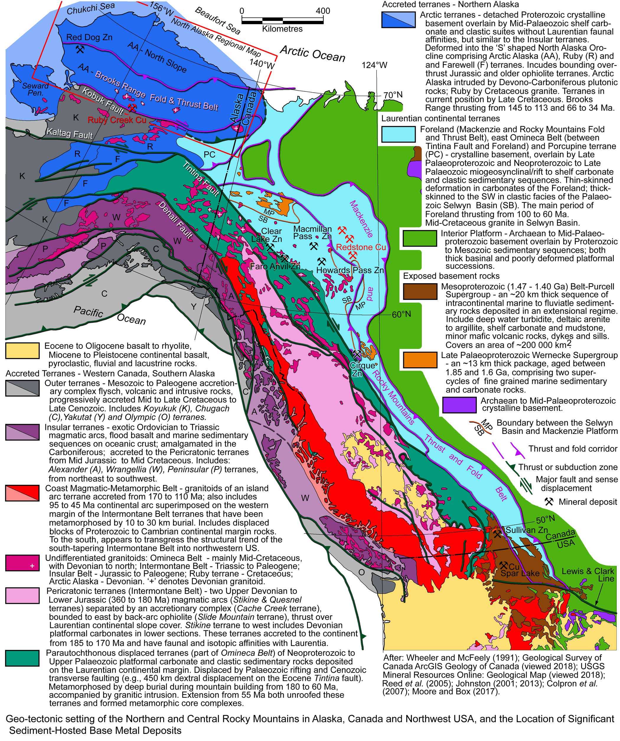
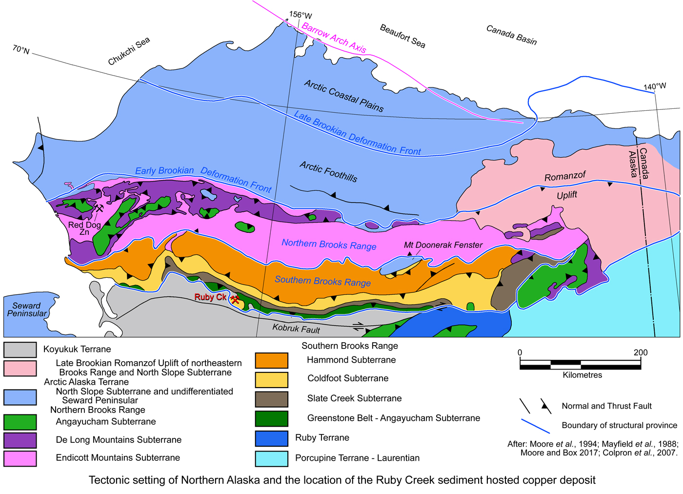
The Ruby Creek deposit is located in the southern Brooks Range of Northern Alaska. Northern Alaska, as regarded herein, comprises the Arctic Alaska Terrane (see the Geo-tectonic Setting map below) which is an exotic terrane (relative to Laurentia) composed of Palaeozoic to Mesozoic cover and Proterozoic basement accreted to North America in the Mid to Late Mesozoic. It is bounded to the south by the major, regional, east-west trending Kobuk Fault, and is divided into three parallel physiographic provinces, from south to north, the i). Arctic Mountains, or Brooks Range, a rugged, east-west trending range with elevations of up to 3000 m in the east, decreasing westward; ii). Arctic Foothills, a series of lower altitude rolling hills and mesas that vary from as much as 500 m in the south, to ~300 m in the north; and iii). Arctic Coastal Plains in the north, a marshy zone that extends to the Arctic Ocean/Beaufort Sea coast.
These physiographic provinces reflect the dominant structural and tectonic character of the terrane imposed on the Neoproterozoic to Mesozoic succession, mostly during the Late Mesozoic and Cenozoic, as follows:
The combined Arctic Foothills and Coastal Plain comprise the North Slope Sub-terrane, which is immediately underlain by Cretaceous and Tertiary sedimentary rocks of the Colville foreland basin overlying a thick Neoproterozoic to Lower Cretaceous suite of platformal rocks. The northern margin of the Colville Basin is marked by the Barrow Arch, a geanticlinal feature, the subsurface core of which is occupied by late Neoproterozoic to Lower Carboniferous rocks and follows the Beaufort Sea coastline. The southern margin is the pronounced deformational front of the Brooks Range which was overthrust onto the North Slope Subterrane. The transition from the Arctic Foothills to the Coastal Plain reflects a deformation front between relatively gentle thin-skinned fold deformation in the south, to virtually undeformed rocks to the north, as described below.
The northern margin of the North Slope Sub-terrane is occupied by the passive margin shelf and deep water Canada Basin below the Arctic Ocean.
The Brooks Range (Arctic Mountains) physiographic province is characterised by intense thrusting and folding that stacked and metamorphosed allochthonous (relative to the Arctic Alaska Terrane) sub-terranes of Neoproterozoic to Cretaceous rocks and produced the Brooks Range Foreland Fold and Thrust Belt. The latter also includes autochthonous thrusting and folding in the NE Brooks Range where the foreland belt transgresses the southern North Slope Subterrane and exposes Late Neoproterozoic and Palaeozoic rocks. This foreland thrust and fold belt is part of a continental scale feature that extends from the Chukchi Sea to the west of Alaska, through the Canadian cordillera, to southwestern USA. It was formed in two main episodes:
i). Early Brookian deformation commenced with contraction during the Late Jurassic. Early penetrative deformation and high-temperature metamorphism affected basalts and siliciclastic sedimentary rocks below the mafic and ultramafic plutonic rocks that were obducted to form the Brooks Range ophiolites and the overlying mafic to ultramafic-rich Angayucham Terrane. This metamorphism and deformation is concentrated along the southern margin of the Brooks Range, throughout the Seward Peninsular and follows the core of the Ruby Terrane to the south. It occurred during the early stages of southward subduction of the down-going oceanic plate and overlying sediment load on the leading edge of the Arctic Alaska Terrane. This plate was subducted below forearc crust of an arc on the leading edge of the Koyukuk Terrane, which was advancing from the south (Moore and Box 2016; Patton and Box, 1989). The Brooks Range ophiolites, along the southern margin of the Arctic Alaska Terrane, have geochemical characteristics of supra-subduction zone ophiolites formed in a forearc setting above subduction zones (Harris, 2004).
The onset of the main phase of more intense Early Brookian deformation commenced during the Lower Cretaceous (Berriasian, ~145 Ma). This is interpreted to have corresponded to the arrival of the continental crust on the south-facing margin of the Arctic Alaska Terrane and its collision with, and southward subduction/underthrusting beneath the oceanic volcanic arc on the northern margin of the Koyukuk Terrane (Box, 1985; Moore, Grantz and Roeske, 1994). Subduction persisted until the Mid Cretaceous (Late Aptian, ~113 Ma) and produced a thin skinned, north-vergent fold and thrust belt ahead of the advancing Koyukuk Terrane. Allochthons within this belt were transported for tens to as much as several hundred kilometres from the south, and stacked in the Brooks Range. These allochthons, now mainly preserved in the Northern Brooks Range, were composed of platformal cover on the Arctic Alaska Terrane. Deeper in the crust, the continental basement to the thick pile of imbricated allochthons was subjected to subduction metamorphism. The latter produced a penetratively deformed, blueschist-facies metamorphic belt in the Southern Brooks Range and Seward Peninsula.
Subsequent relaxation and rebound is interpreted in the metamorphic hinterland in the Albian (from ~113 Ma), resulting in the uplift and exposure of metamorphic rocks in the core of the southern Brooks Range and Seward Peninsular during the late Early Cretaceous (Vogl, 2002, 2003). This accompanied a phase of post-orogenic extension during the Albian and Cenomanian, which may have begun as early as the Early Aptian. Extension and decompression during this event also led to the uplift of ovoid blocks of metamorphosed rocks from greater depths (core complexes), surrounded by outward dipping thrust surfaces, and younger Mesozoic sedimentary and volcanic rocks, e.g., the 30 x 10 km Comos Hills block in which the Ruby Creek deposit is located (see the Deposit Geology section below).
Rotational opening of the Canada Basin to the north, and anticlockwise rotation of Arctic Alaska during the Lower Cretaceous (Hauterivian to Aptian; Chian et al., 2016) is interpreted to have temporally overlapped the subduction-related thrust imbrication to the south.
ii). Late Brookian deformation - ~30 m.y. after the middle-Cretaceous extensional exhumation of the Early Brookian deformation belt, a second pulse of north vergent contraction commenced in the Paleocene (~66 Ma) and persisted until the Eocene (~34 Ma), superimposed upon structures of the previous event. Unlike the thin-skinned character of the Early Brookian deformation, this episode is characterised by a thick-skinned, more deep-seated thrust style that also involved basement. The leading edge of this new event is just to the north of the Northern Brooks Range in Cretaceous foredeep strata of the southern Arctic Foothills physiographic province. The remainder of the Arctic Foothills province has been affected by thin-skinned fold deformation occurring as a belt of detachment folds that fade to the north into the Arctic Coastal Plains, where little Cenozoic deformation is evident.
Within the northeastern Brooks Range, however, the thick-skinned thrusting and uplift extended north to the continental margin, producing a major (~350 x 150 km) salient into sections of the Arctic Alaska Terrane not affected by the Early Brookian deformation. Deformation in this salient, which is known as the Romanzof Uplift (Moore et al., 1994) is constrained to be <60 Ma by widespread fission track ages (Moore and Box, 2016). It resulted in the northward migration of foredeep deposition across the Barrow Arch and onto the adjacent northern Alaska continental margin (Moore and Box, 2016). Deeply
rooted thrust faulting resulted in erosion of much of the Mesozoic and Palaeozoic succession and exhumation of the underlying Proterozoic basement rocks (Wallace and Hanks, 1990). North-vergent shortening deformation continued in the frontal northeastern Brooks Range, and to the continental margin into the Oligocene and Neogene.
During the Late Brookian event, large scale (up to 450 km) dextral transcurrent displacement had been occurring on the major, continental scale Tintina Fault in Canada and southeastern Alaska (e.g., Gabrielse et al., 2006). In eastern Alaska, the NW-SE trending Tintina Fault is rotated to being close to east west in the Kaltag Fault. As a consequence, part of the dextral strike-slip component of motion on the Tintina fault was necessarily transformed to north-vergent thrust displacement in the Brooks Range and Porcupine terranes to accommodate the change in fault trajectory (Oldow et al., 1989). Similar dextral transcurrent displacement on the Denali Fault to the southwest, which also markedly changes trend in southern Alaska has resulted in thick-skinned folding in the Ruby, Farewell and displaced terranes in central and southern Alaska (e.g., Moore and Box, 2016). This generally north-vergent stress field may be related to the same mantle-crust dynamics as the late collision and accretion of the Yalutat Terrane to the south.
 Click here to expand
NORTH SLOPE SUB-TERRANE
Four broad sequences are recognised in and below the Colville Basin that occupies the North Slope, namely:
• Pre-Carboniferous - buried to depths of up to and exceeding 10 km, comprising a succession of mostly steeply dipping and weakly metamorphosed, thin-bedded argillite, siltstone and fine grained quartzose sandstone with locally interbedded greywacke, limestone, dolomite and chert. The sequence contains fossils of Mid-Ordovician to Mid-Devonian age. Locally these are overlain by >100 m of chert-pebble conglomerate and sandstone, interbedded with sandstone, siltstone, carbonaceous shale and claystone with Early to Mid-Devonian fossils. These rocks are truncated above by an angular unconformity.
To the east, in the Romanzof Uplift of the northeastern Brooks Range, the lowest rocks of the pre-Carboniferous sequence of the North Slope are extensively exposed where transgressed by the foreland fold and thrust belt. These rocks are of Neoproterozoic to Devonian age, a similar sequence to that found in the core of the Barrow Arch. They include Neoproterozoic quartzite, argillite, probable continental tholeiitic basalt and dolostone, ~1100 m of Late Neoproterozoic to Ordovician limestone and 72 m of Devonian limestone. The Pre-Carboniferous succession has been deformed by Romanzof Deformation (Moore and Box 2016) structures of Late Devonian age and intruded by scattered 1 to 80 km diameter, post-kinematic, Devonian and Lower Carboniferous granitic plutons (Oldow et al., 1989). Whilst this succession within the northeastern Brooks Range has been deformed by both Devonian Romanzof and mainly Cenozoic Brookian deformation, the section north and west of the foreland fold and thrust belt in the North Slope only has structures related to the former. In contrast,the far-travelled allochthonous rocks of the main Brooks Range are only deformed by the Brookian Orogen (Moore and Box 2016). The Devonian Romanzof deformation comprises north-vergent folds and thrust faults that represent significant shortening. Reconstructions by some authors (e.g., Gottlieb et al., 2014) suggest the Romanzof orogen aligns with the south-vergent Late Devonian to Lower Carboniferous Ellesmerian orogen when subsequent rotations are taken into consideration.
Over much of the Mid Devonian to Lower Carboniferous there appears to be a hiatus in deposition over much of the North Slope and Romanzof Uplift, and evidence of a contractional orogenic event, the Romanzof(-Ellesmerian) deformation, including granitic intrusion. During the same interval in the Southern Brooks Range, a well developed carbonate sequence was deposited in an extensional regime, with bimodal volcanism but no contractional deformation. This latter sequence included the hosts to the Ruby Creek deposit.
• Carboniferous to Triassic Lower ElIesmerian Sequence that is generally flat lying and composed of 1 to 2, locally up to 5 km of chert rich marine and non-marine clastic rocks and marine carbonate rocks deposited in a shelf and platform environment along a south-facing continental margin. This succession thins northwards to onlap onto older rocks in the Barrow Arch and thins and fines southwards below the foothills of the Brooks Range. It comprises three transgressive-regressive cycles:
i). Lower Carboniferous to Lower Permian, truncated above by a regional unconformity, composed of lower non-marine to marine clastic rocks and an overlying marine carbonate suite. This sequence commences with the Endicott Group a southward thinning, 500 to 100 m thick conglomerate and sandstone unit with interbedded carbonaceous shale and coal. These pass gradually upwards into the Lisburne Group, <400 to >1200 m of grey to black marine carbonaceous shale with interbedded sandstones and an overlying, ~600 m thick upper argillaceous limestone and dolostone with interbedded sandstone and shale, ranging from platformal in the north to deeper water in the south.
ii). Early Permian to Early Cretaceous, locally separated from the overlying sequence by a basin margin unconformity. It is primarily a clastic non-marine to marine-shelf suite of northern provenance, the Sadlerochit Group. The lower part of the sequence, gradually thickens southward to >600 m. It starts as 100 m thick calcareous mudstone to glauconitic limestone, followed by dark silty shales, then by deltaic sandstones and conglomerates and chert-pebble conglomerate; and
iii). Early to Late Triassic, which commences with a conformably to disconformably overlying, thin, dark assemblage of shale, mudstone and carbonate rocks that is ~100 to 200 m thick, the Shublik Formation, representing a marine transgression over a gently south dipping shelf. A minor regression followed, accompanied by deposition of a widespread, thin, shallow-marine sandstone sequence.
From the Early Permian to Early Triassic, the southern and western sections of the Colville basin were dominated by the Etivluk Group, a thin (~200 m thick) sequence of fine grained, typically well bedded clastic rocks, including shale, siliceous argillites and grey, greenish-grey to maroon cherts, has been interpreted to reflect starved basin conditions in and inner to outer shelf environment.
• Jurassic to Lower Cretaceous Upper ElIesmerian Sequence, which is up to 1.2 km thick, corresponds of an ~100 m.y. period of extension related to the onset and break-up of the Pangea supercontinent. This resulted first in a graben, the Dinkum Graben, in northern Alaska and the Beaufort Sea, and then the separation and displacement of the Arctic Alaska terrane from the landmass to the north that had supplied sediment to the preceding shelf sequences from the Neoproterozoic to Triassic. This separation formed the Canada Basin under the Beaufort Sea and Arctic Ocean. The main Upper ElIesmerian Sequence comprises an areally extensive fine grained clastic suite deposited on a south-dipping shelf and slope south of the main Jurassic to Early Cretaceous axis of extension. This sequence, predominantly the Kingak Shale was deposited in a WNW to NW trending trough that occupies the northern half of the North Slope. It was largely marine, principally composed of dark grey to black, non-calcareous, pyritic shale, with relatively minor pebble shale and sand lenses. Uplift along the incipient Arctic Ocean margin during the Early Cretaceous led to emergence of a 250 km wide, NW trending landmass and semi-regional hiatus in deposition before erosions and deposition of thin, shallow sand sequences. This hiatus produced an unconformity, largely over the Barrow Arch, and was overlain by further shales.
• Upper Jurassic or Lower Cretaceous to Holocene Brookian sequence comprises a thick pile of sedimentary rocks that were shed northwards into a developing foredeep from the emerging Brooks Range Orogenic Belt. This deposition began over 150 m.y. ago in the Late Jurassic and has continued to the present. Deposition may have commenced 30 m.y. earlier in the Mid Jurassic, possibly several hundred km to the south and transported northward with the allochthonous sequences of the Brooks Range. As such, the sequence may temporally overlap the Upper ElIesmerian Sequence. The younger rocks of the Brooks Range Sequence, were deposited after much of the northward migration of the Brooks Range thrust front and mostly rest on older rocks of the Colville Basin. In contrast the older Brookian Sequences are more strongly deformed. The sequence can be divided into at least 4 sedimentary megacycle packages that grade, laterally and vertically from deep marine basin-plain turbidites, to slope turbidites and shale, to shelf, deltaic and fluvial deposits. These megacycles are from Aptian to Albian (Mid Cretaceous); Albian to Cenomanian (also Mid Cretaceous); Cenomanian to Eocene and Eocene to Holocene. Changes in composition reflect the unroofing of the sequence in the Brooks Range. The thickest sequences are contained within the first two megacycles, when a more than 6 km thick pile was deposited on the southern margin of the North Slope, thinning to <1 km near the current coast of the Beaufort Sea.
The southern margin of the Colville Basin is gently folded at the surface, but is fringed by the west trending Disturbed Belt, the northernmost part of the Brooks Range.
 BROOKS RANGE FOLD AND THRUST BELT
The Brooks Range Orogen is ~1000 km long and as much as 300 km wide. It is composed of a cluster of sub-terranes which lie almost entirely within the Brooks Range Foreland Fold and Thrust Belt, and can be divided into three groupings:
1. Southern Brooks Range Structural Province, which occupies the southern half of the Brooks Range and is the core of the orogenic belt where relatively deep structural levels are exposed. Rocks on the northern margin dip to the north, below the subterranes of the northern half of the orogen, while those on its southern margin dip below the Cretaceous sequence of the Koyukuk Basin, deposited on the accreted outer Koyukuk Terrane. This variation in contact dips reflects folding by the Late Brookian deformation. The southern margin of the province and the Arctic Alaska Terrane is defined by the transcurrent Kobuk Fault which also cuts and displaces rocks of the Koyukuk Basin.
The province is dominated by a series of generally south-dipping packages, mostly bounded by north-vergent, east-west striking thrusts. The main subterranes are, from south to north:
• Greenstone Belt or Brooks Range Ophiolites, an imbricate stack of 4 to 8 thrust slabs of very fine to fine grained, non-vesicular to amygdaloidal and aphyric pillow basalt, pillow breccia and subordinate dolerite, basaltic tuff, argillite, limestone and radiolarian chert with a structural thickness that varies from 6 to 10 km. It extends over an interval of >500 km along the southern margin of the Brooks Range, where it dips moderatley to steeply south below the Koyukyk Terrane cover, and structurally rests on deformed and metamorphosed rocks of the Slate Creek Subterrane. Radiolaria in cherts interbedded with the volcanic rocks define an age progression from bottom to top of the imbricate stack of Late Devonian (Fammennian); Lower Carboniferous, Upper Carboniferous to Permian, Triassic and Early jurassic. Geochemical data demonstrate many are hypersthene-normative tholeiitic basalts (Barker et al., 1988; Pallister et al., 1989) and are transitional between normal and enriched mid-occan ridge basalts (MORB). This mafic sliver has been equated with the Angayucham Terrane (Moore et al., 1994) and is interpreted to include forearc crust of the adjacent Koyukuk arc terrane (Patton and Box, 1989) with geochemical characteristics of supra-subduction-zone ophiolites formed above a subduction zone (Harris, 2004). The greenstone belt represents both the underlying oceanic crust on the leading edge of the Arctic Alaska plate and part of the overlying obducted oceanic crust that is basement to the Koyukuk arc terrane. This composite slice of greenstones is found close to the north of the late transverse Kobuk Fault, and is bounded by strands of that fault.
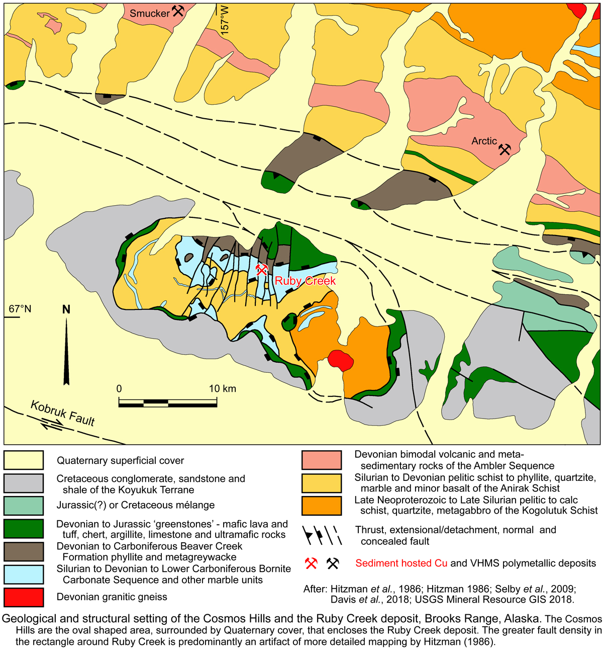
In addition to the basaltic rocks, ultramafic rocks are exposed in the southern Brooks Range and the Cosmos Hills 10 to 20 km to the south sandwiched between the two basaltic suites. In the greenstone belt they occur as scattered fault slivers along the belt, and locally structurally overlying basalts. In the Cosmos Hills they are closely associated with basalts as separate fault slivers enveloping the metamorphic core complex of schists and carbonates that host the Ruby Creek deposit.
• Slate Creek Sub-terrane, that occurs as a 5 to 10 km wide, ~450 km long sliver immediately to the north of the Angayucham Terrane band mentioned above. It also occurs as a ~130 x 50 km klippe on the eastern end of the Brooks Range. In the southern Brooks Range, it comprises metamorphosed, dark, thin-bedded, phyllitic shale to siltstone and fine- to medium grained sandstone, with local chloritic schist, and metagabbro and dolerite dykes. This sub-terrane is largely bounded by faults, although in the Cosmos Hills it has been correlated with the Early Carboniferous Beaver Creek Phyllite (e.g., Selby, et al., 2009) that immediately overlies the Bornite Carbonate Sequence, host to the Ruby Creek deposit. It corresponds to the Phyllite Belt of other authors, and contains rare Devonian fossils. No mappable internal stratigraphy has been recognised, and zones of tectonic melange and broken formation are common, particularly along its southern margin, whilst pervasive phyllonite and mylonite occur along the northern fringe.
• Coldfoot Sub-terrane, which largely consists of fine to coarse grained metasedimentary rocks that forms a continuous Schist Belt over 15 to 25 km wide belt that extends for >600 km along the southern Brooks Range, immediately to the north of the Slate Creek Sub-terrane (Phyllite Belt). This subterrane is distinguished from the Hammond subterrane to the north by its penetrative deformation, generally higher metamorphic grade texture, and smaller proportion and size of enclosed carbonate lenses, as well as its near absence of relict sedimentary and igneous textures. Four primary lithological assemblages have been recognised:
i). Proterozoic and Lower Palaeozoic metasedimentary rocks exposed along the northern margin and in structural windows. Mostly pelitic and calcareous schist and marble, with some quartzite and meta-basic and meta-felsic rocks. Locally intruded by Neoproterozoic (705±35 Ma) granodiorite, but also has Silurian to Lower Carboniferous fossils. These include the Kogoluktuk Schist of Hitzman et al. (1982) that underlie the quartz-mica schist unit in the Cosmos Hills structural window in which the Ruby Hills deposit is located. In this window the Kogoluktuk Schist comprises ~2500 m of interlayered pelitic schist, micaceous quartzite, feldspathic-schist, metabasalt, chlorite-schist, chloritic dolomite and marble (Moore et al., 1994).
ii). Quartz-mica schist unit, composed of generally uniform pelitic and semipelitic schist. It has an estimated structural thickness of 3 to 12 km and is characterised by quartz stringers, boudins and segregations that commonly define isoclinal folds. It is composed of green to grey, brown-weathering quartz + white mica + chlorite + albite ± chloritoid schist with graphitic- and quartz-rich layers that are generally less than a few metres thick. To the east the sequence contains ~5% meta-basic rocks. It represents a thick, deformed, metamorphosed succession of organic-rich shales and siliciclastic sedimentary rocks. The age of this suite is unknown, although Hitzman et al. (1986) regard it as Devonian or older. These schists include the Anirak Schist of the Cosmos Hills and Ambler District that are characterised by quartz stringers and boudins, and segregations that commonly define isoclinal folds (Hitzman et al., 1986; Moore et al., 1994). Both above and below the Ambler sequence, it is a variably graphitic and siliceous quartz-white mica-(chlorite) schist containing thin, impure calcareous beds. The Anirak Schist immediately underlies the Bornite Carbonate Sequence. In the Cosmos Hills, the Bornite Carbonate Sequence is overlain by the Beaver Creek Phyllite. Elsewhere, where the Bornite Carbonate Sequence is absent, the Anirak Schist has a gradational contact with the overlying, 600 to 1800 m thick, Early Carboniferous Beaver Creek Phyllite. This contact is defined on the basis of metamorphic texture and crosses bedding at a low angle (Hitzman et al., 1986a).
A few small granite gneisses, indicated to represent S-type peraluminous granite protoliths of probable Devonian age intrude this schist belt.
iii). Bornite Carbonate Sequence of Hitzman et al. (1986), which comprises ~1000 m of carbonate rocks that may conformably overlie the quartz-mica schist unit. The sequence grades upwards from phyllitic marble to carbonate breccia, marble, massive fossiliferous dolostone and massive encrinitic dolostone, representing a carbonate mudbank complex or bioherm (Hitzman et al., 1986). Lateral equivalents nearby include marble, graphitic marble, carbonaceous phyllite and fossiliferous laminated dolostone interpreted to reflect a back-reef lagoonal and intratidal to supratidal regime. Fossils indicate a Mid- to Late Devonian to Lower Carboniferous age, although a Silurian fossil has also been recognised. This unit hosts the Ruby Creek copper deposit within the biohermal reef facies.
iv). Ambler Sequence of Hitzman et al. (1982), which is best developed in the Ambler District where it hosts significant volcanic hosted massive sulphide Cu-Zn-Pb-Ag deposits and mineralisation (e.g., Sun-Picnic Creek, Arctic and Smucker). The sequence comprises a complexly interfingering and deformed, 700 to 1850 m thick succession of foliated to massive metarhyolite, felsic schist, metabasalt, marble and chloritic-, calc- and graphitic-schist that is inferred to wedge out to the south into the thicker quartz-mica schist unit (Hitzman et al., 1982). The sequence comprises ~60% metavolcanic and volcaniclastic rocks 25% of marble and 15% metasedimentary rocks and has been metamorphosed to blueschist and greenschist facies assemblages. The felsic lithologies are rhyolitic and contain relict potassium feldspar and it resorbed bipyrimidal quartz phenocrysts. The basalt is tholeiitic, massive and concordant, and contains pillow and breccia structures. The volcanic sequence is interpreted to represent a bimodal succession of submarine mafic flows and rhyolite domes, ignimbrites, ash flows, pyroturbidites and reworked aprons of clastic volcanic debris (Hitzman et al., 1982). Sub-alkaline basaltic flows and sills within this sequence have an un-depleted mantle geochemical signature, whilst sub-alkaline rhyolitic to andesitic tuffs and flows have geochemistry consistent with formation from a source that includes melting continental crust (Ratterman et al., 2006).
Corals from the dolomitic lenses within the sequence are Late Devonian to Lower Carboniferous. Age dating of the volcanics gave 373 to 327 Ma for felsic metavolcanics (U-Pb and Pb-Pb zircon; Dillon et al., 1980) and dates of extrusion of 396 ±20 Ma, (i.e., Mid Devonian). These are interpreted to be cogenetic with scattered, small gneissose granites within the subterrane and the neighbouring Hammond Subterrane (Dillon et al., 1980; Dillon 1989). On the basis of these ages the stratigraphy and style of volcanism, the setting of the Ambler sequence is interpreted to be a continental rift regime (Hitzman et al., 1982; 1986).
• Hammond Sub-terrane, extends for almost 800 km along much of the southern Brooks Range, with a width of up to 50 km. It is composed of a series of imbricated sheets containing the following lithological-stratigraphic packages that have phyllitic and schistose textures and greenschist, and locally, blueschist and amphibolite facies metamorphic assemblages:
i). Proterozoic metasedimentary and metavolcanic rocks, which have only been identified locally in structural culminations, where they occur as two imbricated lithologic packages. The structurally lower is a suite of shallow water stromatolitic dolostone and limestone to marble with subordinate phyllite, quartzite, carbonate-cobble conglomerate and pillowed metabasalt. The upper structural plate is composed of interdigitating metavolcanic and metasedimentary units with a prominent metamorphic fabric and no relict sedimentary or volcanic structures. The metasedimentary rocks include interlayered quartzite, calc-schist, pelitic schist and garnet amphibolite, intruded by 750±6 Ma (U-Pb zircon; Karl et al., 1989) granitoids. Hornblende and white mica K-Ar and Rb-Sr ages from the metasedimentary rocks yielded ages of 655 to 594 Ma, whilst the metavolcanic unit was dated (K-Ar hornblende) at 729±22 and 595±30 Ma (Turner et al., 1979; Mayfield et al., 1982; Armstrong et al., 1986).
ii). Pre-Carboniferous Baird Group Carbonate Rocks which characterise the subterrane, occurring widely as prominent, thickly bedded massive to light grey limestone, dolostone and marble up to 1 km thick. These thick bands contain rare Silurian and Devonian fossils, and persist over strike lengths of up to 50 km before pinching out into thinner beds intercalated with clastic sedimentary rocks. Ordovician graptolites have also been discovered in the sequence, which is interpreted to have persisted from the Middle Cambrian to Devonian deposited in a regime that varies from restricted shelf to marine platform to basinal. Some fauna has Siberian craton affinities.
iii). Lower Palaeozoic metasedimentary rocks, which occur in the western part of the subterrane, sandwiched between thrust sheets that contain the carbonate rocks described above. Lithologies include black carbonaceous quartzite and siliceous argillite with lenses of dolostone and marble, pelitic schist, chert-pebble conglomerate, calc-schist, thin bedded micaceous marble and metabasalt. Elsewhere, further to the east, phyllitic calcareous siltstone and sandstone are intercalated with black carbonaceous phyllite. These sequences carry Cambrian and Ordovician fauna.
iv). Devonian metasedimentary rocks which are widely distributed with in the subterrane, particularly in the north where they form a foliated imbricated assemblage on black, calcareous, chloritic and siliceous phyllites, slate, carbonate- and quartz-pebble conglomerates, greywackes, sandstone, chert and limestone lenses and metabasalt. Fossils are largely absent and correlation is on the basis of lithology. Three primary assemblages have been locally recognised, namely a lower suite of coarse grained clastics, a middle heterogeneous unit and an upper phyllite-slate assemblage.
v). Carboniferous to Permian, comprising sections of the sequence recognised in the North Slope Subterrane. These are: the Endecott Group, 100 to 200 m of cross-bedded quartzite and pebble to cobble conglomerate and intercalated phyllite, overlain by 300 m of black carbonaceous phyllite, slate and argillite, which unconformably overlie Devonian granitic rocks and older carbonates of the Baird Group; Lisburne Group, 100 m of medium-to thick bedded, grey to black limestone and white dolomite with chert nodules; Sadlerochit Group, <100 m of an unfossiliferous, schistose succession of calcareous, fine grained quartz sandstone and interbedded siltstone.
iv). Meta granitic rocks of Proterozoic and Devonian age. The former occur as widespread, commonly fault bounded stocks, and are associated with significant gabbros and leucogabbros. They are highly evolved and mildly peraluminous, interpreted as 'within-plate' magmas derived from a
weakly fractionated source, emplaced in a non-arc contmental setting (Karl et al., 1989).
The younger granitic rocks occur as an east-west belt of several elliptical, 5 to 50 km long metamorphosed plutons that are also commonly fault bounded. They are mostly peraluminous muscovite-biotite granites, but range from alkali feldspar granite to tonalite. Some younger plutons are associated with isoclinally folded augen gneiss, schistose orthogneiss, aplitic and pegmatitic gneiss. Other plutons are foliated metaluminous porpjhyritic biotite ±hornblende granodiorite and leucogranite with associated diorite, quartz monzonite and tonalite. These granitoids have been variously dated 366 ±10 and 402 Ma (U-Pb zircon; Dillon, 1989).
The northern margin of the Hammond subterrane is marked by a north dipping and north vergent thrust separating it from the structurally overlying Endicott Mountain subterrane. To the south, both north and south dipping intersecting thrusts separate the Hammond and Coldfoot subterranes. In the eastern half of the terrane, a >50 km long window through the Hammond subterrane, the Mount Doonerak fenster, exposes the underlying North Slope Subterrane across a shallow Lower Cretaceous thrust that was folded into an antiform during the Oligocene (O'Sullivan et al., 1998). The northern margin of this window is shared with the Endicott Mountains subterrane and is ~75 km south of the tectonic front between the Brooks Range Orogen and the North Slope, confirming the former has been thrust over the latter. However, the Neoproterozoic and Lower Palaeozoic rocks exposed in this window are structurally different from coeval units in the northeastern Brooks Range (Romanzof Uplift) by having no penetrative Romanzof(-Ellesmerian) structures.
2. Northern Brooks Range Structural Province, encompasses the main axis of the Brooks Range Orogen. It is a gently north sloping plateau between the higher range to the south and the foothills to the north. It contains prominent, dominantly north vergent fold and thrust structures, although the rocks are only locally metamorphosed and penetratively deformed. The various stratigraphic sequences of the province are regionally extensive thrust packages, occurring as stacked allochtons. The subterranes and allochthons are:
• Endicott Mountains Subterrane, which extends for ~900 km from the Chukchi Sea to near the Canadian border in the east. It is entirely composed of rocks of the Endicott Mountains allochthon, and is the lowest of a stack of seven major allochthons of the Brooks Range. It is predominantly a Devonian to Carboniferous sequence that is correlated with the Endicott and Lisburne groups of the North Slope succession as described above. However, in the allochthon, these groups differ from that sequence on the North Slope in that they have a faulted base, contain a regressive Upper Devonian sequence, lack a sub-Carboniferous unconformity, and contain a much thicker suite of clastic rocks. The basal unit of the allochthon is the Devonian Beaucoup Formation, which comprises a ~550 m heterogeneous marine assemblage of phyllitic, calcareous, siltstone and shale with lenticular limestone bodies. The overlying Endicott Group is up to 4500 m thick. It is a deep marine shale, overlain by shallow marine sandstone and then fluvial conglomerates, followed by the shallow marine Lower Carboniferous Kayak Shale. These are, in turn, overlain by the Mid to Upper Carboniferous Lisburne Group, interpreted to represent a slowly subsiding open marine shelf, interfingering with a euxinic basin to the south and west. It includes shallow marine limestones grading laterally into the deep marine, ~100 m thick, Kuna Formation, composed of sooty phosphatic black shale and dolostone, interbedded with black, radiolarian chert. This unit hosts the stratabound Red Dog Zn-Pb-Ag deposit. These are disconformably overlain by members of the Etivluk Group, composed of the basal, disconformable, ~115 m thick, Permian, Siksikpuk Formation siltstones and mudstones, some of which are pyritic, while others contain barite and siderite. The upper member of this group, the Triassic to Jurassic, ~100 m thick Otuk Formation intercalated black, graphitic and dolomitic shales, with lesser cherts, represents a condensed sequence in an open marine, middle neritic to inner bathyal regime, distant from a sediment source (Murchey et al., 1988; Bodnar, 1989). The lower Otuk Formation is correlated with the Shublik Formation of the North Slope subterrane (Moore et al., 1994). The conformably overlying Jurassic to lower Cretaceous Ipewik unit contains ~100 m of grey and maroon shale, concretionary mudstone, oil shale and coquinoid limestone, representing a condensed, quiescent marine basin setting, possibly deposited on a ridge separating the stable Ellesmerian shale basin to the north (Kingak Shale) from the Brookian foredeep basin to the south (Moore et al., 1994). These are overlain by a finger of Brookian foredeep sediments, represented by the Upper Jurassic to Lower Cretaceous Okpikruak Formation which is >600 m thick and comprises grey, deep-marine mud stone, and minor thin-bedded sandstone and polylithic conglomerate. The latter represents turbidites with local olistostromes deposited possibly in a foredeep that migrated northward with the advancing Brooks Range thrust front (Moore et al., 1994).
• De Long Mountains Subterrane, which is the structurally highest of the Arctic Alaska subterranes, comprises four of the seven allocthons recognised in the Northern Brooks Range. In ascending order these are the Picnic Creek, Kelly River, Ipnavik River and Nuka Ridge allochthons. None are present everywhere in the subterrane, but where two or more are found together, they are always in the same vertical order. All are bounded by thrust faults. They are principally concentrated in the central to western Brooks Ranges with lesser outliers to the east. All contain very similar Lower Carboniferous to Lower Cretaceous stratigraphic units to those mapped in the adjacent North Slope and Endicott Mountains subterranes, but differ in lithological/facies content. The succession is as follows, from the base:
i). Baird Group - which is represented in all but the Picnic Creek Allochthon. It is 200 to >500 m thick, and predominantly composed of Devonian and older carbonate rocks, mainly limestones with lesser dolostones (except in the Kelly River Allochthon, where they dominate) and interbedded grey clastic and calcareous shales;
ii). Endicott Group - that is absent from the Kelly River Allochthon, but present in the remaining three. In the Picnic Creek Allochthon, the sequence is composed of a ~40 m thick, Lower Carboniferous prodelta sandstone, underlain by a 40 to 100 m thick Upper Devonian prodelta shale and overlain by the shelf environment, 15 to 40 m thick Kayak Shale. In the Ipnavik River and Nuka Ridge allochthons, only the Kayak Shale is recognised where it is 40 to 70 m, and up to 350 m thick respectively.
iii). Lisburne Group - which is not mapped in the Nuka Ridge Allochthon, but is present in the other three. In the Picnic Creek Allochthon, the Lisburne Group is represented by 87 m of Mid Carboniferous thin-bedded, black chert with rare shale partings and dolomitic beds (Akmalik Chert), conformably overlying the Kayak Shale. In the Kelly River Allochthon, where the Endicott Group is absent, it is thickest, with an up to 1 km of Lower Carboniferous carbonate rocks resting conformably on the Baird Group. In this allochthon, it comprises a lower, 10 to 1000 m thick shallow shelf sequence (Utukok Formation) of fine quartz sandstone, calcareous sandstone, sandy limestone and calcareous shale, which may be a correlative of the Endicott Group elsewhere. These are followed by ~650 m of shallow shelf fossiliferous limestone (Kogruk Formation), and then up to 230 m of Mid to Upper Carboniferous, deep shelf, thin bedded dark limestone and nodular to bedded chert (Tupik Formation). In the Ipnavik River Allochthon, the Lisburne Group is up to 250 m of deep shelf, interbedded black chert, siliceous shale, dark grey micritic limestone and fine grained dolostone which conformably overlies the Kayak Shale. In contrast, in the Nuka Ridge Allochthon, the Endicott Group is succeeded by the Nuka Formation, a shallow marine to non-marine, ~300 m thick, Mid Carboniferous sequence of interbedded limestone to arkosic limestone, arkose and
quartz sandstone that conformably rests on the Kayak Shale. This unit grades laterally into coarse sandstones and conglomerates.
iv). Etivluk Group - of Permian to Lower Jurassic age is present in all four allochthons, and is composed of deep shelf cherts with variable interbedded shales that range from 75 to 150 m in thickness. However, within the Kelly River Allochthon, the group has a higher proportion of shales and has been divided into the Siksikpuk and Otuk formations, similar to those described above in the Endicott Mountains Subterrane.
v). Okpikruak Formation - the youngest unit in all four allochthons, composed of locally derived flysch, as described above for the Endicott Mountains Subterrane, interpreted to reflect northward progradation of the Brookian Thrust in the Upper Jurassic to Lower Cretaceous.
3. Angayucham Subterrane, which is interpreted to be a separate exotic 'terrane'. It occurs as klippen (up to 150 x 50 km) of generally weakly metamorphosed, mafic volcanic rocks, dolerite, gabbro and ultramafic rocks that are discontinuously distributed over the length of the Brooks Range, principally over the sedimentary rocks of the De Long Mountains and Endicott Mountains subterranes in the Northern Structural provinces. They occur in two allochthonous sheets that have been eroded into a number of remnant klippen:
• Copter Peak Allochthon, which is the structurally lower, composed of imbricated units of basalt and dolerite with lesser basaltic tuff, and breccia, microgabbro, siliceous tuff, radiolarian chert and grey argillite. The basalt is generally very fine to fine grained, amygdaloidal, massive and strongly fractured, with recognisable pillows and lava flows, and is almost completely altered to albite, amphibole, chlorite, titanite and calcite. Dolerite dykes and sills intrude the basalt and intercalated sedimentary rocks. The allochthon is <3 km thick. Geochemical data show the basalts to be tholeiites, and suggest extrusion at a mid-ocean ridge or seamount. However, samples from one locality are consistent with an oceanic arc origin. Radiolarian chert and interbedded limestone near the base of the pile suggest ages of Late Devonian, Lower and Upper Carboniferous and Triassic (Moore et al., 1994 and sources cited therein).
• Misheguk Mountain Allochthon, is made up of ultramafic tectonite and cumulate rocks, and gabbro and dolerite with an original thickness of at least 6 km where best developed. The ultramafic rocks are predominately dunitic containing chromite layers, with subordinate harzburgite, wehrlite and pyroxenite. These pass upward, via an interlayered zone, into layered gabbroic cumulates, including troctolite, melagabbro, leucogabbro,
and anorthosite. Variable amounts, from dominant to subordinate, of non-cumulate gabbro, locally intruded by small plagiogranite dykes and stocks occur as irregular intrusion in most klippen. Dolerite dykes intrude both the ultramafic and gabbroic rocks, as do late K feldspar granites. Gabbros in several klippen have yielded K-Ar ages of 172 to 147 Ma and 40Ar-39Ar 187 to 184 in others, i.e., in the Mid to Late Jurassic, after the Copter Peak allochthon.
It is likely the Angayucham Subterrane and equivalent Greenstone Belt on the southern margin of the Southern Brooks Range Structural Province represents oceanic crust and overlying intraoceanic arc volcanic rocks on the leading edge of the advancing Koyukuk Terrane that has been obducted over the oceanic and then continental crust of the Arctic Alaska Terrane. On the southern margin of the Arctic Alaska Terrane, Angayucham Subterrane rocks areoverlain by Jurassic to Cretaceous mélange rocks.
Cosmos Hills Evolution
The geoteconic evolution of the Cosmos Hills, where the Ruby Creek deposit is located, on the southern margin of the Arctic Alaska Terrane, may be summarised as follows:
• Deposition on a passive margin to extensional shelf regime to the south of a cratonic land mass in the north that was the source of sedimentary detritus. Deposition commenced in the Late Neoproterozoic, and continued to the Early Carboniferous.
• Extension may have increased in intensity during the Devonian, corresponding to ~386 Ma granitic intrusion and 373 to 327 Ma bimodal volcanism.
• During the Jurassic Early Brookian Deformation, oceanic crust on the leading edge of the Arctic Alaska Terrane began to be subducted below oceanic crust of the Koyukuk Terrane to the south. This procuced arc volcanism on the latter plate as it progressed northward, overriding and obducting the shelf on the southern margin of the Arctic Alaska Terrane. As obduction progressed, the overriding southern plate 'bulldozed' the upper sections of the shelf sequence ahead of its path and imbricated them to the north in a thin skinned deformation event. This event juxtaposed sucessions, originally deposited over widths of hundred of kilometres into a narrower, thicker, stacked pile of allochthons that formed the Brooks Range. As the Brooks Range grew, it shed detritus to the south to form a Jurassic to Cretaceous mélange and then coarse Cretaceous sequences of the Koyukuk Basin.
• Differences in the sequence within the Cosmos Hills and the Ambler Sequence 20 km to the north, as described above, infers the two areas are within separate allochthons, deposited at different locations to the south prior to northward transport during the Early Brookian Deformation.
• Obduction persisted until the imbricated pile of Brooks Range allochthons encroached onto continental basement and became too thick to continue. At this stage, a new subduction zone most likely formed much further to the south, and the Brooks Range underwent significant isostatic rebound and post-orogenic extension during the Mid Cretaceous. This resulted in the development of a series of low angle extensional detachments, some possibly following earlier thrust planes.
• Extension and decompression during this event led to the uplift of rocks from different depths and metamorphic grade and their juxtaposition across detachments in the Southern Brooks Range Structural Province, forming a core of gneisses and schists, grading outwards to the Schist and then Phyllite Belts.
• The Cosmos Hills may be interpreted to represent a more restricted metamorphic core complex just to the south of the main Southern Brooks Range Structural Province. In the core of this structure, shelf sequences of the Arctic Alaska Terrane that were overthrust by oceanic crust and overlying cover of the Koyukuk Terrane during the Early Brookian Deformation were updomed and exposed as a window, framed by mafic volcanic and ultramafic rocks of the latter terrane.
• The extension producing the metamorphic core complex dome resulted in the juxtaposition of rocks from different depths. The centre of the complex is occupied by granitic gneiss intruding the Kogoluktuk Schist of the Schist Belt, then the Anirak Schist, Bornite Carbonate Sequence and Beaver Creek Phyllite, which together form the Phyllite Belt. These are followed outward and upward by the overlying mafic rocks of the Angayucham Subterrane and Jurassic to Cretaceous sequence of the Koyukuk Basin. Each of these units, is separated by a domed, shallow angle detachment, like the outer layers of an onion.
• The Paleocene to Eocene Late Brookian Deformation faulted and folded Cosmos Hills, offsetting detachments, and folding the core complex dome and earlier structures, and in doing so promoted erosion and exposure of the core complex.
Cosmos Hills Geology
The geology and setting of the Cosmos Hills are described above in the Southern Brooks Range Structural Province section and illustrated on the accompanying image. In summary, the main stratigraphic units are, from oldest to youngest:
Late Neoproterozoic to Late Silurian
► Kogoluktuk Schist - ~4000 m of predominantly coarse-grained pelitic schist, with subsidiary quartzite, metagabbro and thin marble lenses that has been metamporphosed to epidote to amphibolite facies with a coarse metamorphic fabric (Hitzman et aI., 1982; Hitzman, 1983). This suite is interpreted to be a metamorphosed package of marine siltstones, sandstones and shales (Hitzman, 1986). It is separated from the overlying Anirak Schist by a major structure, either a thrust or detachment zone (Hitzman, 1986).
Upper Silurian to Lower Carboniferous
► Anirak Schist - ~3000 m of greenschist facies pelitic, mildly graphitic quartz-rich schist to phyllite which is locally calcareous, with interbedded quartzite, lesser marble, argillaceous dolostone, and tan-green coloured phyllite with minor metabasalt. It is of Silurian to Lower Carboniferous age, but mainly Devonian. In the immediate Ruby Creek/Bornite deposit area it mostly comprises strongly sheared graphitic quartz-muscovite schist with interlayered coarse-grained, quartzite and thin marble bands. Here it has been interpreted to be a metamorphosed sequence of black shale, siltstone, sandstone and limestone (Hitzman, 1986). Fine-grained pyrite is found in some fine-grained micaceous and carbonaceous layers and in some marble bands, but is locally recrystallised into 1 to 500 µm diameter grains. The contact with the overlying Bornite Carbonate Sequence is typically sharp, strongly sheared, and occasionally folded (Conner, 2015). It is interpreted to represent both an unconformity and a structural contact.
► Bornite Carbonate Sequence - 200 to 1000 m of greenschist facies marble, argillaceous marble, dolostone, phyllite and phyllitic marble, representing both platformal and deeper water facies rocks. It is lithologically variable both vertically and laterally and is apparently of Devonian to Lower Carboniferous age, although sparse Late Silurian fossils have been recorded. It is only found within the Cosmos Hills, and is interpreted to be a stratigraphic equivalent to sections of the both the structurally underlying Anirak Schist and structurally overlying Beaver Creek Phyllite. This sequence hosts the Ruby Creek/Bornite mineralisation where the most volumetrically significant protoliths were marbles with varying amounts of phyllosilicates and graphite. Dolostone bodies are most prominent in the lower and middle sections of the sequence, with lenses of a tan-green phyllite towards the base.
In more detail, it is composed of the following facies in the deposit area (Conner, 2015):
• Marble - which ranges from pure calcite to impure marbles containing significant white mica, minor quartz and variable graphite and pyrite. The dominant lithology is a thinly laminated, variably phyllitic marble which occurs at the base of the sequence at the easternmost edge of the Ruby Creek/Bornite deposit and dominates the middle and upper portions of the carbonate sequence. It generally grades upwards into argillaceous-graphitic marbles that have alternating bands of light-grey, graphite and mica-poor marbles with bands or lenses of black, graphitic and argillaceous marble (Conner, 2015).
The grain size of calcite within the marble is inversely proportional to the amount of white mica and graphite in the marble (Conner, 2015).
Cleaner marble is well foliated, has a blue to grey colour, is primarily composed of 20 to 350 µm diameter recrystallised calcite grains accompanied by up to a few percent mica and trace carbonaceous material. It comprises alternating light and darker bands that are generally 10 to 50 µm thick, and locally folded. Sedimentary textures or fossils are rare, although coral or crinoid fragments are occasionally seen (Conner, 2015).
The more phyllitic marbles may be well foliated or exhibit apparent relict bedding and contain up to 10% white mica with minor chlorite, quartz and commonly minor graphite. They are gradational with graphitic marble, which occurs as bands with less calcite than the grey marble, but up to 4% white mica and 5% carbonaceous matter. The latter commonly carry up to 10% framboidal and cubic pyrite, whilst more graphitic marble may contain up to 50% pyrite. The graphitic marble contains calcite grains from 5 to 150 µm in diameter and typically 1 to 5 µm in diameter mica grains. Sedimentary features, particularly graded bedding and slump structures are common within graphitic marble, which may also contain detrital fossiliferous debris, mostly crinoidal. Sedimentary textures are best preserved in the more highly graphitic marbles (Conner, 2015).
A visually and chemically distinct tan to green phyllitic marble unit occurs towards the base, composed of dolomite or calcite with up to 15% phengite, muscovite and biotite. They may contain 10 to 30 vol.% feldspar, generally K feldspar, but locally dominantly albite. The consequent high K and Ca of these rocks differentiates them from other argillaceous carbonate beds in the Bornite Carbonate Sequence, the underlying schists and overlying phyllites.
• Marble-bearing debris flow breccia - which occurs as an apparently syndepositional polylithic debris flow breccia in the lower Bornite Carbonate Sequence. It is contains randomly oriented, 1 to 2 and up to 700 mm diameter clasts of light grey marble, black fenestral diagenetic dolostone and light-grey dolomudstone, set in a matrix of calcite, lesser dolomite, up to 10% mica and variable graphite. The matrix colour varies with the graphite content, ranging from black to light-grey. This lithofacies occurs as a tongue that has sharp contacts with both underlying and overlying argillaceous-graphitic rnarbIe (Conner, 2015).
• Dolomitised debris flow breccias and dolomitised bodies - Dolomitisation is the dominant alteration style associated with the Ruby Creek/Bornite mineralisation and will be discussed in more detail in the alteration section below. A number of varieties of dolomite have been recognised relate to alteration affects. Dark grey to black dolostone in which sparse to abundant fossil debris are common occurs throughout the Bornite Carbonate Sequence throughout the Cosmos Hills, and was considered by Hitzman (1983) to represent an early, diagenetic dolomitisation. A generally pale grey dolostone in which millimetric to centimetric relict bedding is preserved, as well as rip up clasts or edge-wise breccia beds. This variety occurs at Ruby Creek, but is more common at Pardners Hill 5.5 km to the WSW and was interpreted by Hitzman (1983) as also being of diagenetic origin and evidence of a shallow marine to evaporitic, sabkha setting. A fine to medium-grained, generally massive dolostone that rarely displays original sedimentary textures or fossil debris. A fine to medium-grained, generally massive dolostone, rarely with any preserved sedimentary textures or fossil debris represents the bulk of the dolostone within the Bornite Carbonate Sequence and is regarde to be of late diagenetic to hydrothermal origin (Conner, 2015). This massive dolostone forms three main zones or bodies, the
i). Basal Dolostone Body, which is up to 300 m thick and 1 km wide, and has an unclosed NNE elongated extent of ~2 km. It is the thickest of the three and is composed of massive, light grey dolostone enclosing what appear to be several dolomitised polylithic debris flow breccias. These debris flows contain 1 to 200 mm 'diameter', subangular to rounded dolostone clasts within a fine-grained matrix of anhedral dolomite grains with <1% very fine-grained white mica. These clasts are poorly sorted, randomly oriented and have sharp contacts with the matrix. The clasts are dominantly fenestral dolostone, bioclastic wackestones and packstones, and featureless dolo-mudstone with lesser clean calcareous marble, dolograinstone, normally graded dolopackstone, oolitic dolowackestone, coral clasts and thinly laminated dolo-mudstone with stromatoporoid fossils. These dolostone debris flow breccias are texturally similar to the 'marble-bearing debris flow breccias described above, and are elongated, trending NNE. The largest of the debris flows within the Basal Dolostone Body has a fan-like geometry, whilst four similar sized debris flow bodies have tongue-like shapes that range from 200 to 850 m wide and 30 to 130 m thick in the north, tapering to 5 to 10 m wide and 3 to 5 m thick in the south. These dolomitised debris flows are surrounded by a fine-grained, grey dolostone. The massive dolostone lacks sedimentary textures and is composed of <1 to 30 µm, anhedral dolomite grains with up to 4% insoluble residue, mostly quartz and mica (Runnells, 1963). Contacts between the massive dolostone and debris flows are sharp. Hydrothermal dolomitisation appears to have preferentially taken place within the more permeable debris flows with hydrothermal fluids then penetrating outward into surrounding and dolomitising the enclosing more massive limestone (Conner, 2015: Davis et al., 2018).
ii). Intermediate Dolostone Body is situated ~100 m above the western section of the Basal Dolostone Body and has a elongated pancake-like geometry. It is ~1500 m long, 850 m wide, and 75 to 100 m thick. It is composed of massive, fine-grained, light-grey dolostone similar to the Basal Dolostone Body. with lesser flow breccias (Conner, 2015: Davis et al., 2018).
iii). Upper Dolostone Body, which is ~700 x 600 m and 200 m thick, and is almost circular in plan, occurring above the western edge of the Intermediate Dolostone Body. It is composed of very similar dolostones to those described for the Intermediate Dolostone Body (Conner, 2015: Davis et al., 2018).
Davis et al. (2018) differentiate the following lithotypes within the Bornite Carbonate Sequence for the purposes of mapping and drill core logging, each of which has up to 5 lithofacies. These are:
- Limestone (or marble) - includes three main mapped lithofacies, namely, relatively pure marble/limestone, thin bedded limestone and carbonate sedimentary breccia that have not undergone dolomitisation. The breccia predominates and consists of 10 to 90% polylithic carbonate clasts supported in a calcareous matrix. The clast lithologies include limestone, dolostone, ferroan dolostone and locally massive pyrite.
- Carbonaceous calcareous phyllite (or carbonaceous phyllitic marble) - weakly to moderately carbonaceous and calcareous phyllite defined by the presence of a significant (5 to 95%) shale-rich component in the carbonate section. This lithotype is divided into 5 lithofacies reflecting the amount of phyllite, carbonate and graphite, and the degree of brecciation. The more phyllitic rocks often act as limits that bound mineralisation.
- Dolostone and Dolostone breccia - which are alteration products and include dolomitised carbonate and dolomitised carbonate sedimentary breccia composed of ±90% polylithic clasts (0.5 to 50 cm in diameter). These lithofacies are the equivalents of the non-dolomitised limestone/marble lithofacies described above, and are the host to mineralisation at Bornite/Ruby Creek.
- Bleached calcareous phyllite - interpreted to be an altered equivalent of the carbonaceous calcareous phyllite described below, with which it is texturally similar. The bleached appearance is a reflection of the characteristic, often strong white mica component, historically misidentified as talc. This group is divided into four lithofacies, reflecting the subdivision of the Carbonaceous calcareous phyllites.
Detailed re-logging and interpretation of drill core from the Bornite Carbonate Sequence, as reported in Davis et al. (2018), indicates the debris flows described above are stacked. Each is composed of basal non-argillaceous channelised debris flows breccias, with a fining upward sequence of increasingly argillaceous-rich breccias, capped by high Ca phyllites. These breccias are laterally confined to channels between highs composed of either thin-bedded or massive platform carbonates. Drilling suggest thickening of the debris flows, which are lobate in form, into a deeper water basin to the north. Davis et al. (2018) report two apparent stacked debris flow sequences, the Lower and Upper reefs. The Upper reef passes upward into capping argillaceous limestones rather than discrete high Ca phyllites, indicating an upward shallowing or filling of the debris flow channels. A series of individual debris flow cycles have been interpreted.
Low Ca phyllites, such as those of the unconformably and structurally underlying Anirak schist and the structurally capping Beaver Creek Phyllite (see below) most likely had a different provenance to the locally derived high Ca phyllites of the debris flow dominated Bornite Carbonate Sequence stratigraphy. In addition to the stacked sedimentary stratigraphy, a crosscutting breccia known as the P-Breccia has been identified in and around the South Reef mineralisation which contains high grade copper. It remains unclear whether the P-Breccia is a post-depositional structural, hydrothermal or solution-collapse induced breccia (Davis et al., 2016).
The lithotypes and mineralised reef sequences at Ruby Creek, described above, occur as 10 cycles, as follows, from the structural contact with the overlying Beaver Creek Phyllite to the structural contact with the underlying Anirak Schist (after Davis et al., 2016; 2018). Phyllite = Carbonaceous calcareous phyllite or bleached calcareous phyllite; Δ Δ = marble or dolomite debris flow breccia; blue = limestone/marble or dolomite:
| | Thickness
(m) | Mineral- isation | Description |
| | 0 to 200 | | | Beaver Creek Phyllite |
| Structural contact |
| Δ Δ Δ | 4 | | | Breccia 10 |
| | 12 to 73 | | | Phyllite 10 |
| Δ Δ Δ | 3 to 52 | | | Breccia 9 |
| | 3 to 77 | | | Phyllite 9 |
| Δ Δ Δ | 1 to 87 | | | Breccia 8 |
| | 5 to 161 | | | Phyllite 8 |
| Δ Δ Δ | 4 to 95 | | | Breccia 7X |
| | 1 to 111 | | | Phyllite 7X |
| Δ Δ Δ | 3 to 150 | | | Breccia 7Y |
| | 2 to 119 | | | Phyllite 7Y |
| Δ Δ Δ | 5 to 295 | | | Breccia 7 - Upper Reef Zone 7 mineralisation,
the Number 1 Orebody |
| | 3 to 178 | | | Phyllite 7 |
| Structural zone separating the Lower and Upper reef sequences |
| Δ Δ | 8 - 215 | | | Thin Bedded Limestone A, grades into Breccia 6 which is absent east of No. 1 orebody - Lower Reef Zone 6 mineralisation at South Reef. |
| | 2 to 134 | | | Phyllite 6 |
| Δ Δ | 5 - 78 | | | Thin Bedded Limestone B, grades into Breccia 5 - Lower Reef Zone 5 min. |
| | 5 to 152 | | | Phyllite 5 |
| Δ Δ Δ | 2 to 184 | | | Breccia 3 - Lower Reef Zone 3 mineralisation |
| | 2 to 110 | | | Phyllite 3 |
| Δ Δ Δ | 2 to 157 | | | Breccia 1 - Lower Reef Zone 1 mineralisation |
| | 6 to 177 | | | Basal dolostone |
| Δ Δ Δ | 7 to 94 | | | Breccia 0 |
| | 4 to 68 | | | Phyllite 1 |
| Detachment zone following unconformity |
| | | | | Anirak Schist |
► Beaver Creek Phyllite - >2000 m of lower greenschist facies black phyllites with thin quartzite and marble bands that structurally overlies the Bornite Carbonate Sequence. The phyllites are generally composed of thin bands of fine-grained quartz, chlorite, muscovite and graphite. The unit locally contains bands or beds of marble up to several metres thick comprising coarse-grained, recrystallised calcite, commonly with abundant disseminated pyrite. However, thin marble lenses may often persist for not more than a few centimetres. Locally the phyllite encloses angular clasts of light-grey dolomite, up to 2 to 3 cm in diameter, possibly representing structurally disrupted dolomitised limestone beds. It is commonly highly sheared and locally include tight recumbent isoclinal folds. A thinned section of phyllite correlated with the Beaver Creek Phyllite overlies the Bornite Carbonate Sequence in the Cosmos Hills, but regionally where the latter is absent, it is found immediately above the Anirak Schist. It is apparently of Devonian to Lower Carboniferous in age, and may also in part by a stratigraphic equivalent of the Bornite Carbonate Sequence.
Late Devonian to Triassic
► Angayucham Terrane Greenstones - >500 m of prehnite-pumpellyite facies pillow basalts and tuffs, overlain by fault bounded slivers of ultramafic rocks. The rocks of this terrane are interpreted to be allochthonous with respect to the other sequences of the Cosmos Hills.
Unconformity
Jurassic to Cretaceous
► Mélange - a coarse mélange of possible Jurassic to Cretaceous age either overlies or is structurally interleaved with Angayucham Terrane Greenstones on the northeastern slopes of the Cosmos Hills.
► Shungnak Conglomerate - part of the Koyukuk Terrane, which on the flanks of the Cosmos Hills is unmetamorphosed and comprises ~1000 m of pebble conglomerate, sandstone, siltstone, minor intermediate volcanics - Unmetamorphosed - 1000m
Igneous rocks
Some 14 km SE of the Ruby Creek deposit, an ~2 km diameter, cataclastic granitic orthogneiss is exposed by an incised valley where it cuts the core of the Cosmos Arch. It intrudes Kogoluktuk Schist and is interpreted to have been derived from a monzonitic intrusion. It comprises an assemblage of quartz, feldspar, garnet, epidote and bioite and has a blastoporphyritic texture, and has been dated at386±3 Ma (U-Pb zircon; Till et al., 2008, after McClelland). As such, it predates the 373 to 327 Ma Ambler Sequence (described above) bimodal volcanics found ~20 km to the north of Ruby Creek, but not in the Cosmos Hills.
A number of mafic intrusions have been mapped, including sill-like metagabbro bodies of undetermined age in the upper Kogoluktuk Schist, as well as metamafic 'greenstones' interpreted to have originated as flows and/or tuffaceous sediments (Hitzman, 1986). Although not recognised in the immediate Ruby Creek deposit area, discontinuous stratabound greenstone bodies occur in the Anirak Schist and at the base of the Bornite Carbonate Sequence, particularly west and southwest of the deposit (Hitzman et al., 1982). A probable Cretaceous gabbroic exposure ~200 m wide occurs ~2 km east of Ruby Creek.
Structure
Two separate structural foliations have been recognised. Bedding (S0) can only rarely be measured where phyllite and carbonate are interbedded and it is unclear to what extent it is transposed. A pervasive S1 foliation is evident in phyllites and may be discerned by colour banding and/or stylo-lamination in carbonates. S1 is folded gently on the 10 m scale and locally tightly folded at the decimetre scale. Axial planar S2 cleavage may be locally measured in decimetre scale folding of S1. Both S1 and S2 foliations are interpreted to be of Jurassic in age. The secondary dolostones have resisted the development of strain and foliation, whereas the surrounding limestone and calc-phyllite appear in places to have been attenuated during deformation, complicating sedimentological interpretations (Davis et al., 2016).
This record is currently being updated - as such it is incomplete - the remainder will be available soon
The mineralisation at Bornite occurs as tabular zones that coalesce into crudely stratabound bodies hosted in secondary dolomite. Two significant dolomitic host units have been mapped (after Davis et al., 2016), namely the:
i). Lower Reef, a 100 to 300 m thick dolomitised zone lying immediately above the basal quartz phyllite of the Anirak Schist. This dolomitised mass outcrops along the southern margin of the Ruby Creek zone and is extensively developed throughout the deposit area, hosting a significant portion of the shallow resources in the Ruby Creek zone, as well as higher grade resources down dip and to the northeast in the South Reef.
ii). Upper Reef, a 100 to 150 m thick dolomite band roughly 300 m higher in the section. This zone hosts relatively high-grade resources to the north in the Ruby Creek zone, and appears to lie at an important NE- trending facies transition to the NW of the main drilled area, locally appearring to be at least partially thrust over the Lower Reef stratigraphy to the SE.
Drilling has shown dolomitisation and copper mineralisation in the Upper and Lower Reefs coalescing into a single horizon to the north. The NE- trending Ruby Creek and South Reef zones also coalesce into a roughly 1000 m wide zone of >200 m thick dolomite containing significant copper mineralisation dipping at roughly 5 to 10°N (Davis et al., 2016).
Copper mineralization comprises chalcopyrite, bornite and chalcocite distributed in stacked, broadly concordant and tabular with thicknesses of up to 25 m which follow favourable stratigraphy, within the dolomitised limestone package. It occurs, in increasing grade order, as disseminations, irregular and discontinuous stringer-style veining, breccia matrix replacement, and stratabound semi-massive to massive sulphides. The semi-massive and massive sulphides appear to be more heavily replaced dolomitic breccias and only represent a minor proportion of the resource. The distribution of copper mineral species is zoned around the lower and central part of the individual lenses, with bornite-chalcocite-chalcopyrite at the core, progressing outward to chalcopyrite-pyrite. Additional minor Cu(-Co) minerals include carrollite, digenite, tennantite-tetrahedrite and covellite (Bernstein and Cox, 1986). Stringer pyrite and locally significant sphalerite occur above and around the copper zones, while locally massive pyrite and sparse pyrrhotite occur in association with siderite alteration below the Cu mineralisation in the Lower Reef (Davis et al., 2016).
In addition to Cu, significant Co mineralisation accompanies the bornite-chalcocite assemblage. Co occurs with high-grade Cu as both carrollite (Co2CuS4) and as cobaltiferous rims on recrystallised pyrite grains (Bernstein and Cox, 1986). Appreciable Ag values of as much as 30 g/t Ag are also found with bornite-rich mineralisation in the South Reef and Ruby Creek zones (Davis et al., 2016).
The dominant hydrothermal alteration mineral is dolomite, which is particularly pronounced within: i). certain massive carbonate units; ii). the Lower and Upper reef debris flow breccias; and iii). the P Breccia. More intense and complete dolomitisation occurs at the base of both of the Lower and Upper Reefs (Davis et al., 2016).
Mineralisation is associated with zones of intense dolomitisation, the distribution of which is influenced by the host stratigraphy. On most scales however this dolomitisation is transgressive. There are three main phases of dolomitisation grading upwards and laterally outwards from an elongate core. The outermost is a low Fe dolomite, followed by a ferroan dolomite grading to a siderite core. The dolomitised rocks in the low Fe zone appear homogenous to mottled to brecciated with no remaining sedimentary textures. The breccia 'clasts' are not exotic or rotated, have sharp margins and appear to be due to selective dissolution and introduction of a matrix. The ferroan dolomite and siderite stages cut each of the preceding phases with increasing veining and brecciation textures and dolomite/siderite grain sizes up to 1 mm in a microscopic ground mass. The alteration culminates in a complex late stage crackle breccia vein system of white low ferroan dolomite that cuts all three zones. In large sections of the alteration system these veins comprise more than 15% of the rock (Hitzman, 1986).
Copper grade generally correlates with the intensity of dolomite alteration expressed as Mg/Ca ratios of 0.4 to 0.67. The Fe composition of the carbonates also significantly influences grade. High Fe carbonate species such as siderite and ankerite are almost barren while low Fe dolomites are more strongly mineralised with Cu (Davis et al., 2016).
The outer low Fe dolomites have very little sulphide or Cu. The ferroan dolomite has increasing interstitial pyrite inwards until a band of semi massive to massive pyrite separates the ferroan dolomite from the sideritic core. Minor sphalerite and barite accompanies the pyritic sections of the ferroan dolomite zone. The copper mineralisation is largely associated with the last veining phase, with the best grades being found where these veins cut the massive to semi massive sulphides at the sideritic to ferroan dolomite boundary (Hitzman, 1986).
This zoning produced Fe-rich dolomites zoned around high Fe siderite and ankerite localised down plunge of the lowermost debris flows in the Lower Reef. Low Fe dolomites, zoned around the basal core of high Fe dolomites, are well mineralised, forming an annulus or horseshoe around the core of un-mineralized high Fe siderite and ankerite lying between the Ruby Creek area and the South Reefs (Davis et al., 2016).
The overall dolomite alteration pattern suggests a mineralising fluid sourced from the south, with transport to the north down the principal axis of debris flow emplacement (Davis et al., 2016).
Alteration within the high Ca phyllites capping successive debris flows occurs as albitisation of pre-existing K feldspar and the development of Mg-phengite at the expense of early detrital muscovite, biotite and chlorite. Increased albite and Mg-phengites are characteristically seen as bleaching of the high Ca phyllites with the highest intensities of alteration immediately below strong copper mineralisation in the debris flow breccias (Davis et al., 2016).
Sulphur isotope and fluid inclusion studies indicate temperatures of up to 300° C in the early stages of dolomitisation and 220 to 100° C for the Cu minerals from the core of the 'ore' lenses to their margins. The dolomitised zone carries interstitial crusts of graphite and hydrocarbons suggesting that the fluids permeating the system included hydrocarbons (Hitzman, 1986).
Re-Os dating of sulphides from main stage copper mineralisation (chalcopyrite, pyrite and bornite) from Bornite/Ruby Creek (Selby et al., 2009), produced a Middle Devonian age of 384±4.2 Ma. However, Connor (2015) suggests a post Juro-Cretaceous age based on two lines of evidence: i). albite alteration associated with the mineralising event cross cuts the pronounced Juro-Cretaceous penetrative fabric at Bornite, and ii). the presence of cymrite, a barium-rich blueschist-stable metamorphic mineral related to the Juro-Cretaceous deformation is common within all the various mineralised assemblages (Davis et al., 2016). These suggest significant subsequent remobilisation.
The resource quoted in 1986 was 90 Mt @ 1.2% Cu, including 36 Mt @ 2% Cu (Hitzman, 1986).
Published NI 43-101 compliant resources in May 2016 were (Nova Copper, Inc., 2016):
Open pit - at a 0.5% Cu cut-off
Indicated mineral resource - 40.5 Mt @ 1.02% Cu,
Inferred mineral resource - 84.1 Mt @ 0.95% Cu.
Below pit - at a 1.5% Cu cut-off
Inferred mineral resource - 57.8 Mt @ 2.89% Cu.
References
Armstrong, R.L., Harakal, J.E., Forbes, R.B., Evans, B.W. and Thurston, S.P., 1986 - Rb-Sr and K-Ar study of metamorphic rocks all the Seward Peninsula and southern Brooks Range: in Evans, B.W. and Brown, E.H., (Eds.), Blueschists and eclogites: Geological Society of America, Memoir 164, pp. 185-203.
Barker, F., Jones, D.L., Budahn, J.R. and Coney, P.J., 1988 - Ocean plateau-seamount origin of basaltic rocks, Angayucham terrane, central Alaska:
Journal of Geology v. 96, pp. 368-374
Bodnar, D.A., 1989 - Stratigraphy of the Otuk Formation and Cretaceous coquinoid limestone and shale unit; in Mull, C.G. and Adams, K.E. (Eds.), Yukon River to Prudhoe Bay; Alaska Division of Geological and Geophysical Surveys Guidbook 7. v. 2, pp. 277-284.
Box, S.E., 1985 - Early Cretaceous orogenic belt in northwestern Alaska: internal organization, lateral extent and tectonic interpretation, in Howell, D.G., (Ed.), Tectonostratigraphic Terranes of the Circum-Pacific Region, Circum-Pacific Council for Energy and Mineral Resources, Earth
Science Series, v. 1, pp. 137-145.
Chian, D., Hackson, H.R., Hutchinson, D.R., Shimeld, J.W., Oakey, G.N., Lebedeva-Ivanova, N., Li, Q., Saltus, R.W. and Mosher, D.C., 2016 - Distribution of crustal types in Canada Basin, Arctic Ocean: Tectonophysics, v. 691, pp. 8-30.
Conner, D.T., 2015 - The Geology of the Bornite Copper-Zinc-Cobalt Carbonate-Hosted Deposit, Southwestern Brooks Range, Alaska: M.Sc. thesis submitted to the Colorado School of Mines, 81p.
Davis, B., Sim, R. and Austin, J.B., 2016 - Technical Report on the Bornite Project, Northwest Alaska, USA; an NI 43-101 Technical Report, Prepared by BD Resource Consulting, Inc., SIM Geological Inc. and International Metallurgical and Environmental Inc., for NovaCopper Inc., 169p.
Davis, B., Sim, R. and Austin, J.B., 2018 - Technical Report on the Bornite Project, Northwest Alaska, USA; an NI 43-101 Technical Report, Prepared by BD Resource Consulting, Inc., SIM Geological Inc. and International Metallurgical and Environmental Inc., for Trilogy Metals Inc., 172p.
Dillon, J.T., 1989 - Structure and stratigraphy of the southern Brooks Range and northern Koyukuk basin near the Dalton Highway; in Mull, C.G. and Adams, K.E. (Eds.), Yukon River to Prudhoe Bay; Alaska Division of Geological and Geophysical Surveys Guidbook 7. v. 2, pp.157-187.
Dillon, J.T., Pessel, G.H., Chen, J.A. and Veach, N.C., 1980 - Middle Paleozoic magmatism and orogenesis in the Brooks Range, Alaska: Geology, v. 8, pp.338-343.
Gabrielse, H., Murphy, D.C. and Mortensen, J.K., 2006 - Cretaceous and Cenozoic dextral orogeny-parallel displacements, magmatism, paleogeography, north-central Canadian Cordillera, in Haggart, J.W., Enkin, R.J. and Monger, J.W.H., (Eds.), Paleogeography of the North American Cordillera - Evidence For and Against Large-Scale Displacements: Geological Association of Canada Special Paper 46, pp. 255-276.
Gottlieb, E.S., Meisling, K.E., Miller, E.L., and Mull, C.G., 2014, Closing the Canada Basin - Detrital zircon geochronology relationships between the North Slope of Arctic Alaska and the Franklinian mobile belt of Arctic Canada: Geosphere, v. 10, pp. 1366-1384.
Karl, S.M., Dumoulin, J.A. Ellcrsieck, I., Harris, A,G., and Schmidt J.M., 1989 - Preliminary Geologic map of the Baird Mountains quadrangle, Alaska:
U.S. GeologicaI Survey Open-File Report 89-551, 65p. Scale 1:250 000.
Harris, R., 2004 - Tectonic evolution of the Brooks Range ophiolite, northern Alaska: Tectonophysics, v. 392, pp. 143-163.
Hitzman, M.W., Smith, T.E. and Proffett, J.M., 1982 - Bedrock Geology of the Ambler District, Southwestern Brooks Range, Alaska: Alaska Division of Geological and Geophysical Surveys Geologic Report 75, 1:50,000.
Hitzman, M.W., 1986 - Geology of the Ruby Creek Copper Deposit: Economic Geology, 81, pp. 1644-1674.
Hitzman, M.W., Proffett, J.M., Schmidt, J.M. and Smith, T.E., 1986 - Geology and Mineralization of the Ambler District, Northwestern Alaska: Economic Geology, 81, pp. 1591-1618.
Mayfield, C.F., Silberman, M.L. and Tailleur, I.L., 1982 - Precambrian metamorphic rocks from the Hub Mountain terrane, Baird Mountains Quadrangle, Alaska: in Coonrad, W.L., (Ed.), The united states geological survey in Alaska, Accomplishments during 1980; US Geological Survey Circular 844, pp. 18-22.
Moore, T.E. and Box, S.E., 2016 - Time-slice maps showing age, distribution, and style of deformation in Alaska north of 60°N.: U.S. Geological Survey Open-File Report 2016-1138, 101p.,
Moore, T.E., Grantz, A. and Roeske, S.M., 1994 - Continent-ocean transition in Alaska: the tectonic assembly of eastern Denalia; in Speed, R.C., (Ed.), Phanerozoic evolution of North America continent ocean transitions: Geological Society of America Decade of North American Geology, Continent-Ocean Transect Volume, pp. 399-441.
Moore, T.E., Wallace, E.K., Bird, K.J., Karl, S.M., Mull, C.G. and Dillon, J.T., 1994 - Geology of northern Alaska. in Plafker, G. and Berg, H.C., (Ed.s), The Geology of Alaska, Geologicai Society of America, The Geology of North America - v.G-1, pp. 49-140.
Murchey, B.L., Jones, D.L., Holdsworth, B.K. and Wardlaw, B.R.,1988 - Distribution patterns of facies, radiolarians and conodonts in the Mississippian to Jurassic siliceous rocks of the north Brooks Range, Alaska. in Gryc, G. (Ed.), Geology and exploration of the National Petroleum Reserve in Alaska. 1974 to 1982: U.S. GeologicaI Survey Professional Paper 1399, pp. 697-724.
Oldow, J.S., Bally, A.W., Ave Lallemant, H.G. and Leeman, W.P., 1989 - Phanerozoic evolution of the North American Cordillera; United States and Canada,
in Bally, A.W. and Palmer, A.R., (Eds.). The Geology of North America - An overview: Geologicai Society of America, The Geology of North
America, v, A, Chapter 8, pp. 139-232.
O'Sullivan, P.B., Moore, T.E. and Murphy, J.M., 1998 - Tertiary uplift of the Mt. Doonerak antiform, central Brooks Range, Alaska; Apatite fission track evidence from the Trans-Alaska crustal transect. in Oldow, J.S. and Avé Lallemant, H.G., (Ed.s), Architecture of the Central Brooks Range Fold and Thrust Belt, Arctic Alaska; Geologicai Society of America, Special Paper 324, pp. 179-194.
Pallister, J.S., Budahn, J.R. and Murchey, B.L., 1989 - Pillow basalts of the Angayucham terrane; Oceanic plateau and island crust accreted to the Brooks range; Journal of Geophysical Research, v. 94, pp. 503-504.
Ratterman, N.S., McClelland, W.C. and Presnell, R.D., 2006 - Geochronology and lithogeochemistry of volcanic rocks of the Ambler District, Southern Brooks Range, Alaska: Geologic Society of America, Abstracts with Programs, v. 38, no. 5, p. 69.
Runnells, D.D., 1963 - The copper deposits of Ruby Creek, Cosmos Hills, Alaska; Unpublished Ph.D. Thesis, submitted to Harvard University, 275p.
Turner, D.L., Forbes, R.B. and Dillon, J.T., , 1979 - K-Ar geochronology of the south-western Brooks Range, Alaska: Canadian Journal of Earth Sciences, v. 16, pp. 1789-1804.
Vogl, J.J., 2002 - Late-orogenic backfolding and extension in the Brooks Range collisional orogeny, northern Alaska: Journal of Structural Geology, v. 24, pp. 1753-1776.
Vogl, J.J., 2003 - Thermal-baric structure and P-T history of the Brooks Range metamorphic core, Alaska: Journal of Metamorphic Geology, v. 21, pp. 269-284.
Wallace, W.K. and Hanks, C.L., 1990 - Structural provinces of the northeastern Brooks Range, Arctic National Wildlife Refuge, Alaska: American Association of Petroleum Geologists Bulletin, v. 74, pp. 1100-1118.
The most recent source geological information used to prepare this decription was dated: 2016.
Record last updated: 1/7/2016
This description is a summary from published sources, the chief of which are listed below.
© Copyright Porter GeoConsultancy Pty Ltd. Unauthorised copying, reproduction, storage or dissemination prohibited.
Ruby Creek
|
|
|
Selected References:
|
Bernstein, L.R. and Cox, D.P., 1986 - Geology and Sulfide mineralogy of the Number One orebody, Ruby Creek Copper deposit, Alaska: in Econ. Geol. v81 pp 1675-1689
|
Hitzman M W 1986 - Geology of the Ruby Creek Copper deposit, Southwestern Brooks Range, Alaska: in Econ. Geol. v81 pp 1644-1674
|
Hitzman M W, Proffett J M, Schmidt J M, Smith T E 1986 - Geology and mineralization of the Ambler district, Northwestern Alaska: in Econ. Geol. v81 pp 1592-1618
|
Selby D, Kelley K D, Hitzman M W and Zieg J, 2009 - Re-Os sulfide (bornite, chalcopyrite, and pyrite) systematics of the carbonate-hosted copper deposits at Ruby Creek, Southern Brooks Range, Alaska: in Econ. Geol. v104 pp 437-444
|
|
Porter GeoConsultancy Pty Ltd (PorterGeo) provides access to this database at no charge. It is largely based on scientific papers and reports in the public domain, and was current when the sources consulted were published. While PorterGeo endeavour to ensure the information was accurate at the time of compilation and subsequent updating, PorterGeo, its employees and servants: i). do not warrant, or make any representation regarding the use, or results of the use of the information contained herein as to its correctness, accuracy, currency, or otherwise; and ii). expressly disclaim all liability or responsibility to any person using the information or conclusions contained herein.
|
Top | Search Again | PGC Home | Terms & Conditions
|
|


