|
Renison |
|
|
Tasmania, Tas, Australia |
| Main commodities:
Sn
|
|
 |
|
|
 |
Super Porphyry Cu and Au


|
IOCG Deposits - 70 papers
|
All available as eBOOKS
Remaining HARD COPIES on
sale. No hard copy book more than AUD $44.00 (incl. GST) |
|
|
The Renison (previously Renison Bell) tin deposit is located on the west coast of Tasmania, ~10 km west of Rosebery, 95 km SSW of Burnie and 200 km NW of Hobart (#Location: 41° 47' 46"S, 145° 26' 30"E).
Tasmanian Mines Department records credit the first reported discovery of cassiterite in the area to Ringrose Nicholson who pegged a lease straddling the Ring River, adjacent to Dalcoath Creek, in 1890. He noted in his application that the mineral discovered was tin. One month earlier, George Renison Bell had pegged four leases stretching north from Renison Bell Hill across the Argent River. These leases were based on the Renison gossan outcrop which he described as a lead-silver occurrence. It is regarded as unlikely that George Renison Bell recognised cassiterite in the gossan. Alluvial tin mining and prospecting indicated the primary source to be the stanniferous gossans of Renison, which were found to overly bodies of massive pyrrhotite and minor pyrite carrying very fine cassiterite. The gossan and oxidised sulphide ores were exhausted by 1922. Attempts to free the cassiterite from the massive sulphides did not meet with success until 1936 when a suitable flotation process was developed and a company was formed to work the sulphide orebodies. A diamond drilling program undertaken during 1955-57 indicated that the deposit was larger than previously estimated and mining continued. During the late 1960's drilling outlined the main blind flat lying stratabound orebodies of the "No. 2 and 3 horizons". There was a halt in production from 2003 to 2008, due to low tin prices, before production recommenced and continues through 2015 with substantial resources remaining.
Regional Setting
The Renison deposit is hosted by a thick late Neoproterozoic to Palaeozoic sedimentary and volcanic sequence deposited within the Dundas Trough between two Neoproterozoic blocks, the Tyennan and Rocky Cape massifs to the east and west respectively. Tin mineralisation is associated with the emplacement of Devonian granitoids.
The Tyennan Massif comprises a complex thrust stack of two metamorphic assemblages, typically in fault contact. These are: i). a low-grade (up to greenschist facies) assemblage of metaquartzite and graphitic and chloritic metapelite, derived from an early Neoproterozoic sedimentary sequence broadly similar to those of the Rocky Cape Massif; and ii). an allochthonous high-grade metamorphic assemblage of garnetiferous schist-quartzite-(amphibolite), including mafic meta-igneous rocks with metamorphic grades up to eclogite facies. The protolith of this latter assemblage is thought to be of Mesoproterozoic age, which was metamorphosed during the Early Cambrian (515 to 510 Ma) Tyennan Orogeny (Seymour et al., 2007).
The Neoproterozoic (1000 to 750 Ma) Rocky Cape Group of the Rocky Cape Massif to the west, occupies a large area of northwestern Tasmania, and is considered to represent a block of autochthonous basement to the Palaeozoic sequences of Tasmania, lying west of the limit of the Tyennan allochthon. It comprises a >10 km thick, open marine shelf sequence of cross-bedded quartz sandstone to quartzite, laminated siltstone, pyritic shale and minor dolomite (Seymour et al., 2007).
The Rocky Cape Group equivalent Oonah Formation and correlates on the eastern margin of the Rocky Cape Massif and within the earliest manifestation of the Dundas Trough are 3 to 5 km thick, composed of two lithological associations: i). the predominant, quartzwacke turbidite association of monotonously interbedded quartz sandstone, quartzwacke, siltstone and grey-green to black pelite, which includes minor alkaline dolerite intrusions (Cooee Dolerite) and related lavas on the north coast; and ii). a probable upper subdivision of the formation, which is predominantly pelite and/or carbonate, locally including mafic volcanic rocks and conglomerates (Seymour et al., 2007).
These rocks are unconformably overlain by the Late Neoproterozoic to Lower Cambrian (750 to 520 Ma) sedimentary and mafic volcanic successions of the Togari Group and its correlates (including the Success Creek Group, Crimson Creek Formation in the Dundas Trough). These rocks are widespread in Tasmania, deposited after the ~760 Ma Wickham (previously Penguin) Orogeny. It is composed of four main successions, although only the lower two are evident in the Dundas Trough. These are: i). a lower dolomitic succession with basal siliceous conglomerate-sandstone and diamictite (correlated with the global ~750 to 700 Ma Sturtian event) near the top, representing a widespread phase of shallow marine shelf sedimentation; ii). a phase of ~750 to 700 Ma mafic rift volcanism and associated volcaniclastic and siliciclastic sedimentation; iii). a renewal of shallow-marine carbonate sedimentation later in the Ediacaran (~570 to 545 Ma); and iv). a Cambrian (probably Early Cambrian) phase of deep-water siliciclastic sedimentation.
Within the Dundas Trough, the >1000 m thick Success Creek Group is composed of thickly bedded quartz sandstone units, interbedded in places, particularly immediately below the Renison ore zone, with well bedded and laminated micaceous sandstone, siltstone and shale. This group concordantly overlies the Oonah Slates and Quartzites, and in turn, passes upwards without interruption into the Lower to Middle Cambrian Crimson Creek Formation via the Renison Marker Horizon. The Renison Marker Horizon is, in general, made up of the following, from the base: i). dolomitic carbonate or black oolitic chert; ii). shale and siltstone, often black and pyritic; iii). dolomitic carbonate; iv). the Red Rock Member, composed of hematitic chert and sandstone, with local minor dacitic tuffs beds; v). dolomitic carbonate; vi). an upper blood red chert. This sequence is one of the few recognisable marker units in the Success Creek Group-Crimson Creek Formation succession.
The overlying Crimson Creek Formation is a >1000 m thick sequence of monotonous green, grey and purple siltstone and mudstone with an ~50% component of fine grained volcano-clastic greywacke. The greywacke beds are poorly bedded and poorly sorted. They have a high opaque minerals content and contain fine clasts of intermediate to basic volcanics, plagioclase and pyroxene crystals, and devitrified glass. Scour and fill structures, graded bedding and wisps of siltstone towards the base of coarser layers, are taken to suggest a turbidite type origin.
During the early phase of the 515 to 510 Ma Tyennan Orogeny, the east-facing Tasmanian passive margin collided with an oceanic arc, resulting in obduction of a sheet of allochthonous Early Cambrian mafic to ultramafic complexes across Tasmania from the east (Berry and Crawford, 1988; Crawford and Berry, 1992; Turner et al., 1998). During this same period, imbrication of the Rocky Cape Massif juxtaposed different metamorphic facies rocks of the Rocky Cape group to form the Arthur Lineament. Similar imbrication during this same event juxtaposed the differing metamorphic facies of the Tyennan Massif described above (Seymour et al., 2007).
Post collisional extension that expanded the Dundas Trough, was accompanied by deposition of the early Middle to early Late Cambrian Mount Read
Volcanic arc immediately to the East of Renison, which comprises andesite to rhyolitic volcanic and volcaniclastic rocks and equivalent intrusions. During the Middle Cambrian, the Dundas Group was deposited in the Dundas Trough to the west of the Mount Read Volcanic arc. This unit comprises a suite of fossiliferous sedimentary and volcanic rocks, including a fine-grained flysch sequence of marine sandstone, siltstone and conglomerate, which is typically turbiditic and quartz-rich to polymict.
At the end of the orogeny, these sequences were all overlain by the Upper Cambrian to Lower Devonian Wurawina Supergroup, composed of thick Late Cambrian to Ordovician Owen Group molassic siliciclastic rocks and Gordon Group limestones, and Silurian to Lower Devonian Eldon Group shallow-marine quartz sandstones, shelf-facies shales and minor limestone, and middle Early Devonian shales (Banks and Baillie, 1989).
In the Middle Devonian, most of Tasmania was affected by the polyphase Tabberabberan Orogeny deformation, which occurred in two main phases in western Tasmania. The early phase produced NNW-trending folds, which included tightening of north-trending Cambrian folds. The subsequent second main phase of compression produced NW to WNW-trending folds and thrusts, with regionally compartmentalised strain (Seymour et al., 2007).
An extended large-scale granitic intrusion event at relatively high crustal levels commenced in eastern Tasmania at ~400 Ma with the emplacement of
unfractionated I-type granodiorites prior to the main Devonian deformation, and continued to after the close of Devonian deformation, with the youngest intrusions at ~350 Ma on King Island. Crystallisation age data indicate a statistical westward younging regionally across Tasmania, with a statistical compositional trend towards felsic, fractionated I-type and S-type granite and monzogranite with decreasing age (Seymour et al., 2007; Black et al., 2005). All significant Devonian granite-related tin and polmetallic deposits lie within the 4 km granite isobath (Solomon and Groves, 2000).
Local Geology
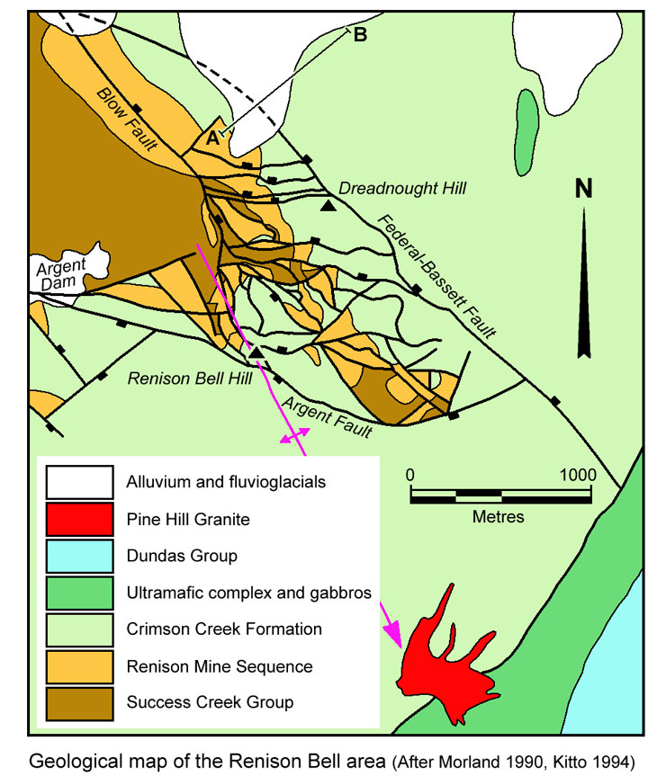
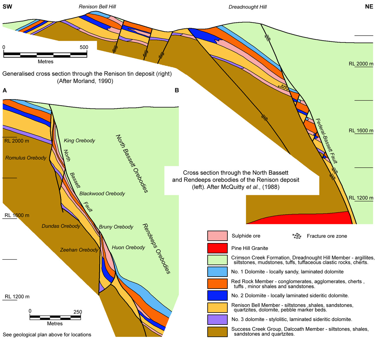
The Renison deposit is hosted by supratidal to intertidal dolomitic and siliciclastic sediments of the Renison Mine Sequence (or Renison Marker Horizon) which comprises the upper ~80 m of the late Precambrian Success Creek Group and the lower ~60 m of the overlying Crimson Creek Formation.
The Renison Mine Sequence ranges from 50 to 200 m in thickness, but is in general around 140 m, with individual cherts and carbonates being from 10 to 20 m thick. There is a considerable thickness variation in the individual components of the marker horizon along strike, a number of which may be absent at any one point. Due to the deep weathering and dense vegetation cover in the area the sequence often has a poor outcrop expression, although in some cases, the cherts form low ridges. The primary carbonates are a manganiferous dolomite or pistomesite, usually well bedded, but becoming coarsely crystalline and sideritic adjacent to the sulphide orebodies. Manganiferous goethite "gossans" often develop on the carbonate outcrops. These do not reflect the presence of sulphides, just the Fe-Mn content of the carbonates.
The Success Creek Group comprises the following, from the base:
• Dalcoath Member - the lowest unit of the Success Creek Group developed in the mine area. It comprises >800 m of thickly bedded quartz sandstone with interbedded finely banded micaceous sandstone, siltstone and shale. Minor pebble beds carrying rounded and broken chert fragments from 0.5 to 2 mm in diameter are found some 80 m below the host No. 3 carbonate. Carbonatic shales occur near the upper margin of the unit, increasing in frequency towards the top. Immediately below the lowermost ore zone, the sandstones and siltstones carry up to 10% tourmaline (dravite) as fine brown laminations and accumulations in slumps, slump breccias and related sedimentary structures over a thickness of up to 300 m. This zone has been encountered in diamond drill core, although it is not obvious in outcrop.
• No. 3 Carbonate - this is the thinnest dolomite unit in the Mine Sequence averaging between 4 and 8 m in thickness. It hosts the No. 3 ore lens.
• Renison Bell Member - this member comprises a lower 60 m of quartzite, and thinly interlaminated quartzite and shale, with around 10 m of pyritic black shale near the top. Carbonatic bands and thin carbonate interbeds are found near the top, while chert and carbonate bearing pebble beds are encountered near the base. These sediments are generally well sorted with a minor argillic component, now largely represented by muscovite. As is the case with the underlying Dalcoath Member, the clastic grains of the sediments are 90% quartz with metamorphic, plutonic and quartz vein provenances. These are accompanied by lesser clasts derived from cherts and primary quartzites. The remaining 10% of the grains are of feldspar (microcline) mica schist and muscovite.
• No. 2 Carbonate - this member is composed of some 20 m of hematitic chert, poorly sorted sandstone, fine grained conglomerate, silicified carbonates and minor possible dacitic tuff. The proportion of each component is quite variable throughout the deposit area.
• Red Rock Member - composed of some 20 m of hematitic chert, poorly sorted sandstone, fine grained conglomerate, silicified carbonates and minor possible dacitic tuff. The proportion of each component is quite variable throughout the deposit area.
The immediately overlying Crimson Creek Formation comprises the following, from the base:
• No. 1 Carbonate - which is from 15 to 20 m thick and embraces the subeconomic No. 1 mineralised lens.
• Dreadnought Hill Member - which comprises the main section of the Crimson Creek Formation, and is made up of at least 800 m of fine grained green, grey and purple mudstone and siltstone with equal proportions of interbedded volcaniclastic greywacke. It is a shallow water succession of turbiditic and volcaniclastic sedimentary rocks, interbedded with tholeiitic lavas (Kitto, 1990), and is exposed over most of the northern, southern and eastern areas of the mine lease.
The Renison Mine Sequence, which extends from the uppermost Dalcoath to lowermost Dreadnought Hill members, is interpreted to represent two regressive and a partial transgressive cycle of subtidal-intertidal-supratidal and fluvial units (Morrison, 1982). The three main stromatolitic-oolitic facies units within the sequence, namely the No. 1, 2 and 3 carbonate horizons, each were formed as an extensive supratidal platform, thought to be continuous with the Smithton Dolomite to the northwest, and have undergone diagenetic or hydrothermal alteration from an originally clastic limestone (Morrison, 1982).
Both the Success Creek Group and Crimson Creek Formation belong to the broader Togari Group as detailed above.
The Serpentine Hill Ultramafic Complex, described by Berry and Crawford (1988) as part of a late Early Cambrian allochthonous thrust sheet, occurs 2 km east of the mine area and passes in an arcuate manner 2.5 km south of the mine at Pine Hill (Kitto, 1994).
In the far SE section of the deposit area, the Middle Cambrian Dundas Group outcrops adjacent to the ultramafic complex (Kitto, 1994). The Dundas Group conglomeratic flysch sequences overly the Crimson Creek Formation and at least part of the ultramafic complex (Elliston, 1954; Banks, 1962; Blissett, 1962), across boundaries that are typically faulted (Brown, 1986 & 1989).
The Devonian Pine Hill Granite is exposed at Pine Hill, in the southeast region of the mine lease (Kitto, 1994). This highly fractionated tin granite forms a NW plunging spine beneath the deposit area, encountered in drill holes along the axis of the Renison Anticline at depths of around 1000 m, and is interpreted to represent a ridge in the upper surface of the regional batholith exposed as the Heemskirk and Granite Tor batholiths to the WSW and ENE respectively. The Pine Hill granite is classified as ilmenite-series, and is reduced (Fe3+/(Fe2+
+ Fe3+) ratio of 0.14), peraluminous, and has corundum normative values between 0.8 and
1.5. Plots of major, trace and REE analyses of the unaltered Pine Hill Granite show well developed fractionation trends indicating ~60% Rayleigh fractionation during crystallisation. Beneath Renison, an apophysis of late stage quartz-feldspar porphyry granite generated a high temperature boron and fluorine-rich fluid, which caused in-situ sericitisation, albitisation and tourmalinisation (Kitto, 1994).
This intrusion is cut by the mineralised Federal-Bassett Fault zone, and intrudes the Dalcoath Member to the SW, and the Dreadnaught Hill Member to the NE. It is regarded as the likely source of the hydrothermal fluids responsible for carbonate replacement mineralisation at Renison (Leaman, 1990; Lea, 1991; Kitto, 1992, 1994). Minor porphyritic granite dykes radiate northwest from the apex of the Pine Hill intrusion across the mine lease.
In addition, a number of minor probable Jurassic dolerite dykes cross-cut the mine lease in a NNW trend through the underground mine workings.
Structure
The Renison ore deposit occurs on the NE limb of the broad, SE plunging, Renison Bell Anticline, which constitutes a horst block bounded to the NE
by the NW-SE trending, 60 to 85°NE dipping Federal-Bassett Fault, to the SW by the subparallel Blow Fault and to the south by the east-west striking Argent fault. Other faults parallel to the Blow series are found between the two main bounding fault systems. The horst is ~700 m to 1 km wide and 3 km long. No definite Mine Sequence rocks have been found in the hanging wall of the Federal-Bassett Fault in the south where the displacement is up to 700 m, although further north a throw of 500 m down to the NE has been estimated on this structure (Morland 1990, Kitto, 1994), where the mainly stratabound Rendeep ores are found at depth in the Mine Sequence (McQuitty et al., 1998).
Between the Blow-Argent and Federal-Bassett fault complexes, there are a series of steep to moderate, both the north and south dipping, generally east-west trending, transverse normal fault sets. These faults strike obliquely to the main structures, but tend to sub-parallel them for as much as 200 m before steepening and converging. The Federal-Bassett structure forms a double fault structure, with up to 100 m separation. The hanging wall fault is essentially continuous, with only relatively small late stage cross fault offsets. In contrast, the footwall structure is highly variable, particularly where the transverse faults branch off. The Federal-Bassett structure is considered by Holyland (1987) and Marjoribanks (1990) to represent a failed pre-Devonian monoclinal fold, related to Devonian F2 events. In the north it is largely an unfaulted monocline.
For more detail of the four phases of brittle deformation recognised at Renison, see the 'Formation of the deposit' section below.
 Mineralisation
Mineralisation at Renison occurs in three main forms, namely: i). stratabound massive sulphide orebodies, ii). fault enclosed massive sulphides and vein clusters, and iii). cassiterite and tourmaline as disseminations and fine veinlets within quartzite
Stratabound Massive Sulphide Orebodies - economic stratabound massive sulphide ore is developed on two stratigraphic levels within the mine, namely within the No. 2 and No. 3 carbonate horizons. Patchy, but subeconomic mineralisation occurs within the No. 1 carbonate, which comprised the only outcropping stratabound ore, and with sections of the fault contained ore, was the basis of the early mining in the field. The No.'s 2 and 3 horizon orebodies were blind, being discovered during the early 1960's by drilling geophysical targets. The No. 2 horizon orebodies average around 15 m in thickness, whilst the No. 3 horizon is some 5 m thick.
The main stratabound orebodies comprise around 70% and occasionally up to 90% sulphides. Pyrrhotite usually makes up 65 to 70% of the total massive sulphide unit with arsenopyrite and spongey pyrite (after pyrrhotite) commonly constituting several percent of the ore over limited areas. Chalcopyrite is a widespread trace mineral while galena, sphalerite and stannite are encountered sporadically.
Tin is present almost solely as cassiterite, usually with a grain size of from 70 to 80 µm. The main gangue minerals within the massive sulphides are quartz, carbonates, fluorite, tourmaline, talc and chlorite. Cassiterite is present in association with both sulphide and non-sulphide bands.
The sulphides are usually fine and well banded at the top and bottom margins of the ore bed. The enclosing rocks commonly only carry a few percent sulphides, as fine disseminations and thin laminae.
The margins of the massive to semi-massive sulphide beds are usually characterised by a decrease in the density of sulphide bands progressively towards the top and bottom, grading into the host rocks over a 30 cm to 1 m width. The main central sections of the ore bed are usually massive in appearance and devoid of visible sedimentary structures in the underground exposures where they comprise mainly fine to medium grained pyrrhotite. In some areas, the ore exhibits a crude banding with abundant cross cutting veinlets of pyrrhotite. In general, the grain size of individual pyrrhotite crystals is around 0.5 mm, with a significant percentage being near or over 1 mm.
The lateral margins of the stratabound ore are usually reasonably abrupt. The sulphide content of the bed 'fades out' over an interval of 1 to 3 m into a zone of strongly developed magnesian siderite. This in turn grades into fresh grey dolomite. Very fine grained, banded, pyritic black cherts carrying low grade tin underlie the No. 1 and in part No. 2 horizon. Pyrite is present as continuous, very thin (1 mm or thinner) laminae and cross cutting hairline veinlets. The chert grades upwards into the massive sulphide as described previously.
Each of the two main stratabound ore bands is segmented into four zones by a series of roughly east-west fault zones. These faults are progressively down-thrown to the northwest by 10, 60 and 15 m respectively. In the shallower parts of the deposit, the ore zone is limited to the NE by the Federal-Bassett structure. The mineralised sequence is in general sharply downturned against this fault, with dips changing from near horizontal to from 45 to 80° within 50 to 100 m of the fault. The massive sulphide ore is cut by the fault in the NW segments of each ore bed, although to the SE, the sulphides have largely lensed out into barren dolomite before being truncated by the Federal-Bassett structure.
The stratabound ore beds extend over a 1.5 km interval from north west to south east and up to 300 m in a north east-south west direction.
The average ore grade of the No. 2 orebodies is 1.18% Sn, while the No. 3 horizon bodies average 1.67% Sn. A number of small cassiterite bearing massive sulphide pods developed on the No. 2 carbonate horizon were mined prior to the discovery of the main orebodies. These had a limited lateral extent, but were developed over thicknesses of up to 10 m. They are separated from the main orebodies by barren intervals of up to several hundred metres.
Fault Enclosed Orebodies - the majority of the fault enclosed ore occurs as three bodies within the Federal-Bassett structure. These are the Federal, and North and South Bassett bodies. Minor mineralisation, seldom worthy of extraction, is also found in the transverse faults displacing the segments of the stratabound massive sulphide bodies. The North and South Bassett bodies, which straddle the central Federal orebody, are very similar in mineralogy and sulphide content to the stratabound massive sulphide deposits. The ore is developed in sections of the fault zone where the adjacent sequence to the south west dips parallel to the fault zone. These two bodies, at least in part, represent mechanically transposed stratabound sulphides. Both orebodies increase in lateral extent with depth, while the enclosed Federal body remains constant in length.
The Federal orebody is quite different in character to the Bassett bodies. It is developed in a vertically plunging eye-shaped thickening of the Federal-Bassett structure, in the centre of a roughly S-shaped irregularity within the fault zone. In its central section, the body is up to 20 m thick. In places the mineralisation is also found outside of the fault zone within the Dreadnaught Hill Member to the north east. Mineralisation occurs as: i). sulphide stringers a few mm's to a few cm's in thickness, made up mainly of pyrrhotite; ii). massive sulphide veins, predominantly fine to medium grained pyrrhotite, from a few cms up to 2 m thick, enclosing and interlacing between abundant fragments of country rock; iii). quartz veins from a few mm's to 30 cm thick with chalcopyrite, arsenopyrite, pyrrhotite and cassiterite; iv). carbonate veins with coarse galena and sphalerite.
The overall sulphide content of the ore zone is around 4%, being made up predominantly of pyrrhotite, with lesser pyrite, arsenopyrite and chalcopyrite, and traces of stannite, galena, sphalerite and bismuthinite. The iron sulphide bearing gangue, apart from the fine grained fragments of host rock and quartz veins, is composed of carbonate, talc, fluorite, apatite and chlorite.
Cassiterite is in general, finer than in the stratabound orebodies, averaging 30 to 40 µm. The average grade of the Federal-Bassett orebodies is 0.95% Sn. The Federal orebody has a maximum length of 300 m. The Federal-Bassett structure is mineralised to varying degrees over a strike length of 2000 m and total down dip length of 800 m. This includes both Federal and Bassett type ores.
Quartzite Mineralisation - occurs in a zone in excess of 20 m in thickness containing some 800 000 tonnes of 1.34% Sn, hosted within quartzites of the Renison Bell Member, immediately above the No. 3 horizon carbonate. This block is bounded to the NE by the Federal-Bassett fault and to the NW and SE by two transverse faults known as the P and L faults, respectively. The No. 3 carbonate is unmineralised immediately below the quartzite orebody. The down dip margin of the adjacent Colebrook orebody within the No. 3 carbonate, roughly corresponds to the up dip, or south-western margin of the quartzite ore.
Mineralisation is present as veinlets and fine disseminations of cassiterite within altered quartzite, comprising glassy quartz and green tourmaline. Similar, minor veinlets and fine disseminations of arsenopyrite and pyrrhotite are found within the same zone.
Other Mineralisation - A zone up to 300 m thick contains up to 10% brown dravite tourmaline within the Dalcoath Member, below the No. 3 carbonate horizon. This tourmaline is present as fine lamina, in brecciated sections and in slumps and sedimentary structures. Within this zone, which like the main orebodies does not outcrop, a few thin 30 cm magnetite-carbonate beds are known. There are also a few thin tremolite-actinolite lenses.
Sections of the Pine Hill adamellite to the south have been extensively altered with the development of black tourmaline-quartz-muscovite and green tourmaline-quartz-muscovite-fluorite-topaz-cassiterite assemblages. Adjacent to this intrusive body, small quantities of tin have been extracted from the Penzance Mine where quartz-tourmaline-cassiterite veins are found cutting Dreadnaught Hill Member sediments.
A number of small Pb-Zn and Pb-Ag occurrences are found on the Renison Marker horizon some 1 to 2 km to the north of Renison Bell.
Formation of the deposit
Kitto (1994) concluded that the formation of the Renison deposit was controlled by:
• a 'spine-like' cupola in the roof of the Pine Hill Granite intrusion that underlies the deposit, from which stanniferous volatile-rich (B, F, Cl) magmatic-hydrothermal fluids emanated;
• structure, commencing with faults initiated during the forceful emplacement of the Pine Hill Granite, and modified by later regional deformation, which acted as both conduits and in part sites of deposition of ore;
• the lithological characteristics of the host rocks, particularly the reactive carbonate hosts.
Based on the gravity profile of Leaman (1990), Lea (1991) proposed the Federal-Bassett Fault Complex was initiated by the tensional regime associated with the intrusion of the Pine Hill Granite. The gravity model suggests a lower density phase of the intrusion occurs at two locations, one corresponding to the Pine Hill greisen, 3 km to the south of the deposit, and the second directly below the deposit. The Federal Bassett Fault Complex is developed along the steep asymmetric eastern margin of the shallowly NW plunging Pine Hill Granite, sub-parallel to the -500 and -2000 m granite roof contours in a zone of structural weakness associated with the monoclinal folding.
Kitto (1994) interpreted four phases of brittle deformation between the Devonian and Tertiary, based on detailed kinematic indicator studies of style and relative ages of striations in mineralised faults. No striations pre-dating mineralisation have been recognised in the Renison vicinity.
The earliest brittle deformation produced normal-dextral movement on all major fault structures in the deposit area, with the most pronounced development along the Federal-Bassett Fault Complex, although similar early deformation is observed on the sub-parallel Blow Fault Complex that represents the western limit of carbonate replacement mineralisation at Renison. These two structures define the Renison Bell Anticline/Horst and straddle the buried 'spine' of Pine Hill Granite. This stress regime in unique to the Renison area. It has not been recognised elsewhere in western Tasmania and does not comply with the regional Devonian Tabberabberan stress field. This initial brittle deformation is interpreted to be associated with the forceful emplacement of the Pine Hill Granite, which resulted in the formation of the Federal-Bassett Fault complex which cuts the Pine Hill Granite at depth. It resulted in up to 700 m of normal-dextral dip-slip movement on that structure, and allowed magmatic-hydrothermal fluids access to the dolomitic host sequence. A high temperature oxide-silicate vein stage (quartz-arsenopyrite-cassiterite) formed during this fault movement. Fluid inclusions associated with this event have homogenisation temperatures ranging from >400°C at the base of the fault (3000 m beneath the Devonian palaeosurface), to 300°C near the top of the deposit. These early NaCI-KCI-H2O brines had average salinities between -8 and 12 wt.% NaCI eq., and fluid pressures of 250 bars (hydrostatic). δ180 fluid values of 9‰ are clearly magmatic, consistent with a fluid which ascended and cooled with the Federal-Bassett Fault before interacting with the wallrocks in the higher mine levels. δ34S fluid values from the oxide-silicate stage are <6‰ and indicate the probable source of sulphur is magmatic (from Kitto, 1994).
As the granite-related stress field decayed, a regional Taberraberran-related dextral wrench reactivated earlier fault structures, and produced a dilational jog in the Federal-Bassett Fault, as well as reactivating most other faults, including the Blow complex and transverse faults. This fault reactivation facilitated a second generation of magmatic-hydrothermal fluids, that ascended within the Federal-Bassett Fault and infiltrated the overlying dolomite horizons. This phase precipitated the main sulphide stage mineralisation (pyrrhotite+cassiterite-quartz-fluorite-stannitechalcopyrite±arsenopyrite and minor base metals) within the stratabound carbonate replacement orebodies that characterise the Renison deposit. In this stage, mineral deposition in the Federal-Bassett Fault took place over a temperature range from <350°C, immediately above the Pine Hill Granite, to ~200°C at the top of the deposit. The deep-level NaCI-KCI-H2O-rich magmatic-hydrothermal brines evolved to CaCl2.MgCI2-NaCI-H20-rich fluids during fluid-rock reactions with carbonates in the upper levels of the deposit. Salinities averaged between 8 and 12 wt.% NaCI eq. throughout the sulphide stage. The distribution of tin and homogenisation temperatures from fluid inclusions define two high temperature tin-rich dilational jogs on the Federal-Bassett Fault, as do variations in δ34S mineral values. δ34S fluid values remained constant at -5‰ throughout the sulphide stage, which Kitto (1994) regards as consistent with a homogeneous magmatic sulphur source (from Kitto, 1994).
The earlier vein stages are overprinted by minor uneconomic base metal veins (rhodochrosite-galena-sphalerite-quartz) and vug-fill carbonate-quartz veins (quartz-carbonate±fluorite±pyrite), both of which are associated with late stage fault reactivations. These late stage veins were associated with low temperature (150 to 200°C), bimodal salinity (<2 and ~10 wt.% NaCI eq.), NaCI-KCI-H20 brines that formed via mixing of meteoric groundwaters with magmatic-hydrothermal fluids. δ34S fluid values of ~5‰) remained unchanged, implying magmatic fluid continued to supply sulphur to the Renison system over a protracted period. These late stage veins record the only fluid inclusion evidence of phase separation at Renison (from Kitto, 1994).
Thermodynamic modelling and fluid inclusion results from the oxide-silicate stage, provide estimates of for the initial magmatic-hydrothermal fluids at Renison of -250 bars fluid pressure, -350°C temperature, salinity -12 wt.% NaCI eq. and pH 3.8 to 5.4 (from Kitto, 1994).
A third set of striations with a reverse-sinistral sense of displacement of no more than a few metres overprint earlier fault striations throughout Renison. The absence of mineralisation during this phase of reactivation indicates hydrothermal fluid circulation had ceased, consistent with a late-syn to post Tabberabberan age of deformation.
The final brittle deformation identified on most fault planes at Renison was a normal-sinistral reactivation with maximum displacements along pre-existing faults of less than two or three metres. This style of faulting is recognised in the Early to Middle Tertiary of Tasmania, due to NE extension (Berry and Banks, 1985; Berry ,1989 ).
Fluid-rock interaction appears to be crucial for cassiterite deposition. Based on numerous simulations of fluid-rock interaction, Kitto (1994) found that reaction with dolomite provides the closest approximation of the actual oxide-silicate, sulphide stage and carbonate replacement mineral assemblages. Kitto (1994) concluded Sn transport in the Renison-type fluid was dominated by SnCI3 and Sn(OH)2CI2 complexes at 350°C and logƒO2 = 33.5, allowing the hydrothermal fluid to carry ~20 ppm ΣSn. At lower temperatures, Sn(OH)2CI2 complexes became dominant. The most effective mechanism for cassiterite deposition, as predicted by numerical modelling, was by redox and pH changes induced by arsenopyrite deposition and carbonate dissolution, respectively (from Kitto, 1994).
Reserves and resources
Total production to 1988 was 10.9 Mt @ 1.2% Sn, with the remaining in situ resource was 13.7 Mt @ 1.2% Sn (Morland, 1990).
Resources + production in 2007 were 24.54 Mt @ 1.41% Sn (Seymour et al., 2007)
Estimated reserves and resources at 30 June, 2015 (Metals X Annual Report, 2015) were:
Total minerals resources - 12.874 Mt @ 1.46% Sn, including 12.011 Mt @ 0.33% Cu,
Total ore reserves - 6.673 Mt @ 1.29% Sn, including 6.352 Mt @ 0.29% Cu.
For more detail see the reference(s) listed below.
The most recent source geological information used to prepare this decription was dated: 2007.
Record last updated: 28/11/2015
This description is a summary from published sources, the chief of which are listed below.
© Copyright Porter GeoConsultancy Pty Ltd. Unauthorised copying, reproduction, storage or dissemination prohibited.
Renison
|
|
|
Selected References:
|
Bajwah Z U, White A J R, Kwak T A P, Price R C 1995 - The Renison granite, northwestern Tasmania: a petrological, geochemical and fluid inclusion study of hydrothermal alteration: in Econ. Geol. v90 pp 1663-1675
|
Denholm, J.L., Stepanov, A.S., Meffre, S., Bottrill, R.S. and Thompson, J.M., 2021 - The Geochronology of Tasmanian Tin Deposits Using LA-ICP-MS U-Pb Cassiterite Dating: in Econ. Geol. v.116, pp. 1387-4407.
|
McQuitty B M, Roberts RH, Kitto P A, Cannard C J 1998 - Renison Bell tin deposit: in Berkman D A, Mackenzie D H (Ed.s), 1998 Geology of Australian & Papua New Guinean Mineral Deposits The AusIMM, Melbourne Mono 22 pp 487-492
|
Morland R 1990 - Renison Bell Tin deposit: in Hughes F E (Ed.), 1990 Geology of the Mineral Deposits of Australia & Papua New Guinea The AusIMM, Melbourne Mono 14, v2 pp 1249-1251
|
Newnham L A 1975 - Renison Bell Tinfield: in Knight C L, (Ed.), 1975 Economic Geology of Australia & Papua New Guinea The AusIMM, Melbourne Mono 5 pp 581-583
|
Patterson D J, Ohmoto H, Solomon M 1981 - Geologic setting and genesis of cassiterite-sulfide mineralization at Renison Bell, western Tasmania: in Econ. Geol. v76 pp 393-438
|
Solomon M 1981 - An introduction to the geology and metallic ore deposits of Tasmania: in Econ. Geol. v76 pp 194-208
|
Walshe J L, Halley S W, Anderson J A and Harrold B P, 1996 - The interplay of groundwater and magmatic fluids in the formation of the cassiterite-sulfide deposits of western Tasmania�: in Ore Geology Reviews v10 pp 367-387
|
|
Porter GeoConsultancy Pty Ltd (PorterGeo) provides access to this database at no charge. It is largely based on scientific papers and reports in the public domain, and was current when the sources consulted were published. While PorterGeo endeavour to ensure the information was accurate at the time of compilation and subsequent updating, PorterGeo, its employees and servants: i). do not warrant, or make any representation regarding the use, or results of the use of the information contained herein as to its correctness, accuracy, currency, or otherwise; and ii). expressly disclaim all liability or responsibility to any person using the information or conclusions contained herein.
|
Top | Search Again | PGC Home | Terms & Conditions
|
|


