|
Cleveland |
|
|
Tasmania, Tas, Australia |
| Main commodities:
Sn Cu
|
|
 |
|
|
 |
Super Porphyry Cu and Au


|
IOCG Deposits - 70 papers
|
All available as eBOOKS
Remaining HARD COPIES on
sale. No hard copy book more than AUD $44.00 (incl. GST) |
|
|
The Cleveland tin-copper deposit is located near Luina, some 14 km to the west of Mt. Bischoff, 38 km north of Renison and 65 km SW of Burnie in north-west Tasmania (#Location: 41° 28' 33"S, 145° 23' 13"E).
Outcrops of gossan were first discovered at Mt. Cleveland in 1898 by a syndicate of prospectors. These were believed to be primarily lead-zinc gossans until a Government geologist visiting the prospect in 1900 recognised that they contained cassiterite. This discovery led to the formation of the Cleveland Tin Mining Company, who worked the deposit from 1909 to 1914 producing 40 600 tonnes of ore which yielded 295.5 tonnes of cassiterite. This operation was based on the outcropping oxidised ore, which gave way at a shallow depth to sulphide lodes composed of pyrrhotite and pyrite with minor chalcopyrite and cassiterite. The tin was found to be difficult to extract from the primary ore and combined with falling tin prices, this led to the cessation of operations in late 1914. Tributing continued until 1917 however, over which period a further 48 tonnes of cassiterite were produced.
The Mt. Bischoff Tin Mining Company carried out an exploration program at Mt. Cleveland during the period 1935 to 1939, but were unable to establish a viable operation.
A geophysical survey undertaken over the area in 1954 jointly by the Bureau of Mineral Resources and the Tasmanian Geological Survey delineated a number of large coincident magnetic and self potential anomalies.
In 1961 the Aberfoyle Tin Development Partnership secured the leases and commenced detailed exploration, based on the 1954 survey results. Surface exploration, diamond drilling and an underground evaluation between 1962 and 1965 resulted in an indicated reserve of 2.90 Mt @ 1.02% Sn and 0.43% Cu being delineated by March 1966. The operating company, Cleveland Tin NL, was formed in June 1966, and construction of a new township (Luina) and a 1000 tonnes per day concentrator and associated facilities commenced in June 1966, and production was begun in 1968. The mine closed in 1986, after having produced 5.9 Mt @ 0.53% Sn, 0.20% Cu. According to Seymour et al. (2007) the total resource + production was 12.4 Mt @ 0.61% Sn, 0.25% Cu.
Published remaining JORC compliant mineral resource estimates at March 2015 (Elementos Limited ASX Release, 3 March, 2015) were:
Open pit (to 150 m depth, 0.35% Sn cut-off)
indicated resource - 0.828 Mt @ 0.81% Sn, 0.27% Cu
inferred resource - 0.014 Mt @ 0.99% Sn, 0.34% Cu
Underground (>150 m depth, 0.35% Sn cut-off)
indicated resource - 4.174 Mt @ 0.67% Sn, 0.28% Cu
inferred resource - 2.428 Mt @ 0.56% Sn, 0.19% Cu
TOTAL mineral resource - 7.444 Mt @ 0.65% Sn, 0.25% Cu.
Underground tungsten resource, from a separate block (>150 m depth, 0.20% WO3 cut-off)
inferred resource - 4 Mt @ 0.3% WO3.
Regional setting
The Cleveland deposit is located in the Dundas Trough of north-western Tasmania. For details of the regional setting, see the separate Renison record.
Geological setting
The Cleveland tin deposit is hosted by shales and cherts which overlie a thick development of greywackes (mica-sandstone), and interfinger with a largely overlying basic volcanic suite. This sequence is un-fossiliferous and is found towards the north-western margin of the Dundas Trough. It overlies a Neoproterozoic quartzite-siltstone-dolostone succession at Mt. Bischoff to the north east, before passing under Tertiary Basalt cover to the north. Almost identical rocks re-appear along the same trend, on the same margin of the Dundas Trough, towards the north coast near Kara and at Penguin. The regional succession in the Mt. Cleveland area can be summarised as follows, from the base:
Proterozoic - The basement to the Cleveland host sequence is represented to the ENE at Mt. Bischoff by an inlier of Neoproterozoic to basal Cambrian Mt. Bischoff Beds comprising quartzite, quartz-sandstone, siltstone, shale and dolostone. To the NW, along the margin of the Rocky Cape Massif, siltstones, shales and quartzites of the late Neoproterozoic to Lower Cambrian Oonah Formation underlie the Cambrian sequence, grading to the NW into the up to blueschist-facies metamorphic rocks of the NE-SW trending Arthur Lineament comprising quartzites, micaceous quartzites, quartz-muscovite-schist, chlorite-muscovite-schist and lesser dolostone and amphibolite. These high grade rocks are juxtaposed to the NW across a SE dipping thrust complex onto lower grade equivalents of the main Neoproterozoic Rocky Cape Group.
Cambrian - The Cambrian sequence along the north western margin of the Dundas Trough has been folded into a series of shallowly plunging, NE-SW trending anticlines and synclines. This succession, which is of an undetermined thickness, but in excess of 800 m, constitutes the Arthur River sequence to the north of Mt. Bischoff. In general, it is made up of a lower shale grading up into poorly sorted greywackes to micaceous sandstones. These rocks have a number of interbedded spilitic lava and basic tuff units with Ocean Floor Basalt geochemical characteristics, some of which have accompanying intercalated red and green chert and shale units. Volcanic centres are obvious in places, reflected by an increased percentage of volcanic rocks, in particular lavas, within the sequence. These are usually accompanied by gabbroic and ultrabasic intrusive bodies, as is the case to the west of Cleveland where two composite serpentinite-gabbro-albite syenite-dolerite pyroxenite-peridotite complexes are known, while to the north and NE, associated dyke and sill-like gabbroic bodies are found. Similar, but smaller, bodies outcrop to the north of the Mt. Bischoff Inlier. The upper parts of this sequence are characterised by further, but often darker greywackes and argillites.
This succession has been interpreted to represent deep oceanic crust, part of an oceanic arc that collided with the east-facing Tasmanian passive margin, resulting in obduction of allochthonous oceanic crust and overlying deep sea sequence and mafic-ultramafic complexes over autochthonous basement across much of Tasmania during the early phases of the 515 to 510 Ma Tyennan Orogeny (Berry andCrawford, 1988; Crawford and Berry, 1992; Turner et al., 1998). The Heazlewood Ultramafic Complex to the west of Cleveland, solidified at 510±6 Ma. The original, shallowly-dipping geometry of the allochthonous sheets has been substantially disrupted by later, Cambrian and Devonian deformation, so that the present surface occurrences are typically steeply dipping and fault bounded (Seymour et al., 2007).
Ordovician and Silurian - Locally, condensed units of red siliceous conglomerate, grey to red quartzite and limestone overlie the Cambrian lithologies.
Devonian to Lower Carboniferous - The 25 x 15 km Meredith granite, dated at 353±7 Ma, cuts the Lower Palaeozoic sequences some 5 km to the south and south east of Cleveland. It is a medium to coarse grained multiphase biotite granite to adamellite.
Tertiary - Minor gravels and remnants of the once widespread Tertiary basalt sheet are found at higher topographic levels within the area.
Mine Geology
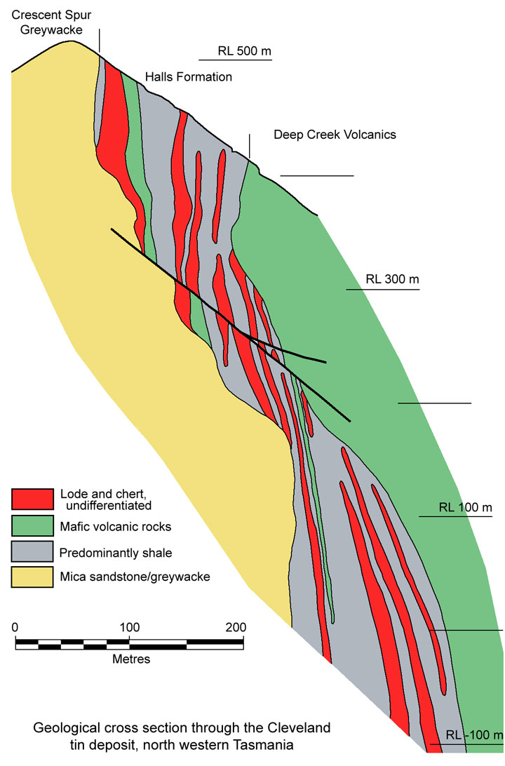
In the mine area, the Cambrian sequence commences with the Crescent Spur Greywacke, overlain by the Halls Formation which comprises intercalated shale, chert, minor greywacke and basaltic tuffs, and hosts all of the orebodies. This formation grades upwards rapidly via an increase in the basic volcanic component, into the Deep Creek Volcanics. Rapid facies changes are common within the mine area. The following is a generalised section of the mine sequence from the base:
Crescent Spur Greywacke (or Mica Sandstone) - This is a sequence of poorly bedded feldspathic and micaceous sandstone, made up of angular to subrounded detrital quartz and feldspar, with varying proportions of dark grey argillaceous material and detrital muscovite, occurring as massive brown to grey rocks with thin interbeds of light to mid-grey shale. It is coarsely micaceous with individual beds ranging from 0.5 to 10 m in thickness. The undulating upper surface of the Crescent Spur Greywacke is believed to represent a depositional surface affecting the facies distribution of the Halls Formation sediments and the ore beds.
Halls Formation - This formation can be broadly subdivided into an upper and lower unit, separated by a thin discontinuous lens of basic lava and tuff, as follows:
• Footwall sequence - shale, and interbedded chert and ore lenses. This chert-ore lens unit, which contains the Henry's and Khaki's Lodes, is at, or close to the base of the unit. Minor greywacke beds are also present.
• Interbedded basaltic lava and tuff, varying from zero to a maximum of 15 m in thickness, known as the Henry's Basic Volcanic Unit.
• Hanging wall sequence - shale with interbedded chert and sulphide lenses, and minor greywacke beds. The ore lenses comprise the upper C-D lodes and the lower and larger A-B lenses known as Hall Lodes. This unit varies from 5 to 100 m in thickness.
The shale is a dark to light grey, grading in places to a purplish grey. It is generally poorly bedded, exhibiting few sedimentary structures and is extensively jointed, and is composed of a micro-crystalline mosaic of quartz and mica with small lenses and blebs of carbonate.
The cherts range from massive to well laminated, and from very fine to medium grained. They are light grey to pink in colour and weather to a light brown to khaki colour, not unlike weathered argillites in appearance. Bedding is usually accentuated by colour changes but is often obvious due to mineralogical variations such as actinolite or carbonate rich layers. Under the microscope, they comprise micro-crystalline quartz, white mica and carbonate, never showing spherical structures. They appear to be of sedimentary origin, representing a very finely bedded tuff. "Jaspery" chert and sulphides are characteristically found close to the orebodies which are intimately associated with the chert lenses and are often thinly interlaminated with them. The cherts range in thickness from zero, up to a maximum of 40 m, and comprise around 20% of each of the Hanging Wall and Footwall sequences. The cherts comprise 30% of the waste within the ore lenses.
The ore lenses are interbedded with the cherts and adjacent shales. To date, eleven have been recognised. As mentioned above, these are divided into two groups, the Footwall and Hanging Wall lodes. The Footwall Lodes are entirely within an up to 40 m thick chert lens at the very base of Halls Formation. This chert lenses out to the NE, SW and down dip, controlled by variations in the underlying greywacke surface.
To the north, a series of steeply plunging rod-like bodies occur within the chert. These are the Henry's Lode lenses. Further to the south, a single larger composite lens is found in the thickest part of the chert lens. This is the Khaki Lode. Some 10 to 50 m above the Henry's Basic Volcanic Unit, another chert lens, or group of lenses, from zero to 30 m thick host the A and B (or Halls) Lodes. These cherts also lens out to the NE and SW. They appear to also lens out down dip as the Halls Formation thins, but are redeveloped below RL 150 as the formation re-develops. A further two sporadic, thin, ore lenses are developed at two main levels with or without accompanying chert in the uppermost 20 to 40 m of Hall Formation. These are the C and D lodes.
To the NE of the main ore zone, the Halls Formation thins rapidly, while to the SW it thickens and becomes coarser, grading to a sandstone at the expense of the shale component.
The grey-green sediments and cherts of Halls Formation grade downwards and laterally to the north east into similar but red shales and cherts.
Similar red cherts are found up to several kilometres away from the orebody within a similar stratigraphic position. A number of small faults cut the orebody. Sedimentary relationships suggest that these are syndepositional. In the upper sections of the mine they have 20 to 30 m throws while the lower faults have displacements of up to 70 m.
The mineralised sequence consistently dips and faces to the south-east at from 80° to vertical.
Deep Creek Volcanics - This sequence comprises,
• Spilitic lava and tuff, 100 to 300 m thick;
• Greywacke, bedded basic tuff, tuffaceous sediment and limestone 0 to 200 m thick;
• Spilitic lava and tuff, >50 m thick.
Spilitic lavas dominate the basic volcanic components of the sequence. They are dark green in colour and massive, with minor quartz chlorite veining, often carrying minor sulphides. They are composed of albite, actinolite and chlorite with accessory quartz, epidote, iron oxide and relict clinopyroxene. No pillows have been recognised although voids resembling vesicles are evident. The lavas are separated by tuff breccias, lapilli tuff and tuffaceous shales. These pyroclastics comprise rounded to subangular fragments set in a fine grained carbonate and chlorite matrix. They are apparently coarser in the mine area and commonly carry disseminated sphalerite, chalcopyrite and rarely cassiterite. Interbedded shales and cherts similar to those of Halls Formation are locally developed within the volcanics at one point, within the southern part of the mine area. One bed of limestone with minor pyrrhotite and chalcopyrite is also found within the volcanics.
The tuffaceous sediments are largely well bedded, dark grey (or green) to purple shales. They are cross bedded in places and obtain their purple colour from disseminated hematite. Pyrite is common in the grey facies.
Ultramafic Intrusives - To the west of the orebody area dark green serpentinites are exposed, believed to have been developed from peridotites, harzburgites and gabbros.
Mineralisation
Eleven ore lenses have been recognised, all hosted within the Halls Formation. Individual lenses attain a maximum thickness of 30 m and are distributed over a total strike length of 600 m. These lenses are contained within a 100 m stratigraphic thickness and have a total down dip extent of around 600 m. Each lens is usually ~10 m thick and ~100 m or more in strike length.
The Halls, or A and B Lodes, are by far the most extensive, with overall dimensions of around 250 x 600 m, while the C, D and Khaki Lodes are each of the order of 100 x 200 m laterally. Henry's Lodes in contrast, occur as a series of small pods and irregular rod-like shoots.
There is a well developed mineral and ore zonation laterally within the orebody. This zonation is represented in all lodes (where present) over the same lateral interval. The mineral and gangue zoning does not coincide precisely with grade classifications which also occur over the same lateral interval in all lodes.
On the basis of grade, four similar but not coinciding zones are recognisable, as follows:
• The northern uneconomic zone - which extends for at least 100 m north of the known economic ore zone and is characterised by a drop in the cassiterite content of the sulphide zone to less than 0.1% Sn. This zone comprises pyrite, arsenopyrite and sphalerite in a dominantly quartz-carbonate gangue.
• The northern ore zone - which carries economic ore over a 300 m length (where lodes are developed) containing around 1% Sn. It is characterised by the presence of pyrrhotite (averaging 35%) with chlorite, cassiterite and stannite. Quartz and carbonate are important, together with minor fluorite (1 to 5%) and very fine grained green tourmaline (<1%). Chalcopyrite averages ~1% and sphalerite <0.1%. Some 5 to 15% of the total tin present (which is near 1%) is as stannite.
• The central un-economic zone - which is about 200 m long and carries the same minerals as the southern economic zone, but in varying proportions. This zone does not outcrop, and is more disturbed than the banded ore further to the north.
• The southern ore zone - which has a maximum strike length of 160 m and carries around 1% Sn. It contains pyrrhotite that is partially altered to spongy pyrite (with a total of 15% iron sulphide) with quartz, carbonate, tourmaline and fluorite (8% average). Some 5% of the total tin is stannite and the remainder cassiterite. There is less chalcopyrite than in the other zones. Sphalerite, chlorite and stilpnomelane are present locally.
The two economic ore zones are texturally distinct. The "northern type" ore is generally finely banded with 35% sulphide as laminae from 1 to 3 mm thick. These are cut by equally abundant crosscutting 1 mm veinlets of pyrrhotite. Chlorite and carbonate bands with associated fine quartz alternate with the sulphides.
The "southern-type" ore has much less well defined banded ore. It has a high proportion of randomly oriented 1 to 5 mm veinlets of sulphide, much of which has been altered to spongy pyrite. The sulphide content as stated above, is only around 15%. The veins are accompanied by carbonate with lesser fluorite quartz and tourmaline.
Cassiterite and stannite are associated with every mineral assemblage in the orebody, although the high grade cassiterite zones are usually more closely associated with quartz. The detailed distribution of tin is very patchy, being distributed in a random fashion.
Copper, ranging from 0.25 to 0.5%, is distributed throughout the mineralised zone, although grade variation are not tied to the tin content.
At the extreme north and south ends of the lode system, sphalerite occurs as irregular veins, associated with carbonate-actinolite zones, totalling around 0.5% Zn. Beneath the southern economic zone a restricted quartz vein stockwork has been recorded. This zone embraces minor 2 cm thick veins carrying quartz with minor wolframite, bismuthinite and molybdenite. Associated alteration only extends a few cms either side of each vein.
The Henry's and Khaki Lodes carry higher grade tin mineralisation than Halls. The former average around 1.2 to 1.3% Sn, while Hall's Lode has near 0.8% Sn. The Khaki Lode however, has less stannite than Henry's Lode. The cassiterite grain size varies from less than 50 µm to 1 mm.
Skarn minerals are developed at depth centred on a topazised quartz-feldspar porphry plug associated with a stockwork of quartz-fluorite veins.
Geochemical & Geophysical Expression
• Geochemistry - Tin levels are not, in general, depleted in surface exposures, although it is not known exactly how far along strike detectable haloes persist. Levels of 0.01 to 0.1% Sn are known however, over a lateral distance of at least 100 m on the northern end of the northern economic mineralisation. Similar cherts to those hosting the ore appear to persist for several kilometres along strike from the ore. Sampling of these cherts indicate that tin levels are not detectable several km along strike although Zn levels of several hundred ppm are encountered.
• Geophysics - A medium level aeromagnetic survey executed in the late 1950's by Rio Tinto Australian Eexploration covering this area yielded a 700 nT above background anomaly, coincident with the orebody. The orebody also gave a strong coincident self potential and ground magnetic anomaly during the 1954 BMR-Tasmanian Geological Survey program. As the orebody exhibits high conductivities over lengths of around 100 m it constitutes a good IP-EM target.
For more detail see the reference(s) listed below.
The most recent source geological information used to prepare this decription was dated: 1990.
Record last updated: 28/11/2015
This description is a summary from published sources, the chief of which are listed below.
© Copyright Porter GeoConsultancy Pty Ltd. Unauthorised copying, reproduction, storage or dissemination prohibited.
Cleveland
|
|
|
Selected References:
|
Collins P L F 1981 - The geology and genesis of the Cleveland tin deposit, western Tasmania: fluid inclusion and stable isotope studies: in Econ. Geol. v76 pp 365-392
|
Cox, R. and Glasson, K.R., 1971 - Economic Geology of the Cleveland Mine Tasmania: in Econ. Geol. v.66, pp. 861-878.
|
Denholm, J.L., Stepanov, A.S., Meffre, S., Bottrill, R.S. and Thompson, J.M., 2021 - The Geochronology of Tasmanian Tin Deposits Using LA-ICP-MS U-Pb Cassiterite Dating: in Econ. Geol. v.116, pp. 1387-4407.
|
Jackson P, Changkakoti A, Krouse H R, Gray J 2000 - The origin of greisen fluids of the Foleys zone, Cleveland Tin deposit, Tasmania, Australia: in Econ. Geol. v95 pp 227-236
|
Mason, A.A.C., 1962 - Tin Ore Deposits of Mt. Cleveland: in Geology of Australian Ore Deposits Eighth Commonwealth Mining and Metallurgical Congress, Australia and New Zealand, The AusIMM, Melbourne, v.1, pp. 503-505
|
Ransom D M, Hunt F L 1975 - Cleveland tin mine: in Knight C L, (Ed.), 1975 Economic Geology of Australia & Papua New Guinea The AusIMM, Melbourne Mono 5 pp 584-591
|
Solomon M 1981 - An introduction to the geology and metallic ore deposits of Tasmania: in Econ. Geol. v76 pp 194-208
|
|
Porter GeoConsultancy Pty Ltd (PorterGeo) provides access to this database at no charge. It is largely based on scientific papers and reports in the public domain, and was current when the sources consulted were published. While PorterGeo endeavour to ensure the information was accurate at the time of compilation and subsequent updating, PorterGeo, its employees and servants: i). do not warrant, or make any representation regarding the use, or results of the use of the information contained herein as to its correctness, accuracy, currency, or otherwise; and ii). expressly disclaim all liability or responsibility to any person using the information or conclusions contained herein.
|
Top | Search Again | PGC Home | Terms & Conditions
|
|


