|
Ailaoshan-Red River Belt - Beiya, Machangqing, Yaoan, Habo, Tongchang, Changan Chong, Daping, Zhenyuan, Jinchang, Mojiang, Changan, Longbohe, Sin Quyen |
|
|
Yunnan, China |
| Main commodities:
Cu Au Mo
|
|
 |
|
|
 |
Super Porphyry Cu and Au


|
IOCG Deposits - 70 papers
|
All available as eBOOKS
Remaining HARD COPIES on
sale. No hard copy book more than AUD $44.00 (incl. GST) |
|
|
The Ailaoshan-Red River Belt is the southern and then southeastern continuation of the ~400 km long, NNW and NW trending Yulong Porphyry Belt, following the same narrow string of late Cenozoic intrusions. Together, these two belts constitute the >1500 km long Jinshajiang-Ailaoshan-Red River Metallogenic Belt, extending from the Tibetan Plateau to the South China Sea.
The broader structural framework within which the Ailaoshan-Red River and Yulong belts developed, initially resulted from the closure of the Palaeo- and then the Meso-Tethyan oceans. This resulted in the progressive collision between a collage of linear microcontinents with the southwestern margin of the South China Cratonic Block and adjacents terranes of the Asian Plate, and took place between the Late Palaeozoic and Late Triassic. Subsequently, the Upper Cretaceous to Cenozoic, north to NE directed closure of the Neo-Tethyan Ocean culminated in collision between the India and consolidated Asia plates. The latter event produced north- to NE vergent folding and thrusting onto the Asian Plate to the north, and intraplate transform strike-slip displacement as well as thrusting to the east. The latter intraplate activity included the Ailaoshan-Red River Fault/Shear Zone that forms the core of the Ailaoshan-Red River Belt. This latter displacement was superimposed upon the tectonic framework of the earlier Late Palaeozoic to Late Triassic collisions over much of the Ailaoshan-Red River Belt.
Mineralisation Overview and Links to Deposit Descriptions
The Ailaoshan-Red River Belt hosts two main clusters of porphyry and porphyry-skarn Cu-Au and Au-Cu deposits, as well as significant orogenic gold mineralisation (Hou et al., 2003, 2007; Deng et al., 2010, 2014; Xu et al., 2012). It also includes significant IOCG, sulphide nickel and sediment hosted Zn-Pb-Ag deposits. Most of these are individually described below, or in separate records, all of which may be accessed via the links in the next few paragraphs.
The first of the 'porphyry' clusters of the Ailaoshan-Red River Belt is located ~200 km WNW of Kunming in southern Yunnan, southwestern China, and includes the Eocene Beiya porphyry-skarn Au, Machangqing porphyry Cu-Mo and the small Yao'an porphyry Au deposits. Numerous other porphyry style prospects are also known (e.g., Deng et al., 2014).
A second cluster of smaller porphyry-style and related deposits and occurrences are located another 350 km to the SE, in southern Yunnan and northern Vietnam, along the continuation of the same structural trend. These include the Eocene Habo, Chang'anchong and Tongchang porphyry deposits in Yunnan Province, China, and the O Quy Ho mineralisation in northwestern Vietnam.
Between the two porphyry clusters and overlapping the southern, there are four significant disseminated gold deposits, which are, the Oligocene Zhenyuan cluster (the largest of which is the Donggualin deposit), Jinchang/Mojiang, Chang'an and the Oligocene orogenic lode-type Daping, plus eight more medium-sized, and numerous small gold occurrences within the broader Ailaoshan-Red River Shear Zone.
To the southeast, in Vietnam, ~25 to 50 km ESE of the Chang'an and Daping gold and Habo porphyry copper deposit, the Sin Quyen magnetite-copper-gold IOCG deposit is located within 500 m to the SW of the Red River Fault, hosted by high grade metamorphic rocks of the Ailaoshan-Red River Shear Zone. Mineralisation appears to have occurred in two stages; i). a 744 to 520 Ma metasomatic alteration phase forming magnetite, uraninite and allanite; and ii). a hydrothermal sulphide event depositing overprinting chalcopyrite, pyrrhotite and pyrite between 35 and 31 Ma (Duong et al., 2021).
Sin Quyen is one of a number of Proterozoic Fe-(Cu) deposits or prospects distributed along the Ailao Shan-Red River shear zone in South Yunnan, China and northern Vietnam, that define the potentially important Longbohe - Sin Quyen Fe-Cu belt. Longbohe is located ~100 km to the NW of Sin Quyen in south-eastern Yunnan, and NW of Lao Cai on the Vietnam-China border and has a resource of more than 1 Mt of contained copper.
Intrusions that are part of the late Permian, ~263 to 257 Ma Emeishan Large Igneous Province (e.g., Shellnutt, 2004) host sulphide nickel mineralisation, e.g., the Baimazhai deposit. This LIP overlaps and occurs along the Ailaoshan-Red River Shear Zone, and extends to the NE, covering >250 000 km2 of the south-western Yangtze Craton. The Baimazhai deposit lies within the Ailaoshan-Red River Shear zone, in close proximity to the Daping gold deposit mentioned above, and the China-Vietnam border. Further south again, just to the south of the Red River Fault and 160 km WNW of Hanoi, the Permo-Triassic Ban Phuc ultramafic hosted massive sulphide nickel deposit occurs within the broader Ailaoshan-Red River Shear Zone. The host intrusive occupies a shear zone and cuts Devonian meta-sedimentary and metavolcanic basement rocks and is interpreted to represent a displaced intrusive of the Emeishan LIP.
Less than 40 km to the west of the northern section of the Ailaoshan Shear Zone, and a similar distance WNW of the Beiya deposit, Cretaceous and Tertiary terrestrial rocks of the Lanping Basin host the giant Jinding/Lanping sediment hosted Zn-Pb-Ag deposit and an extensive cluster of similar smaller Zn-Pb-Ag deposits and occurrences. The generally north-south elongated Lanping Basin is bounded to the east by the Ailaoshan Shear Zone and 30 km to the west by the sub-parallel Congshan Shear Zone (e.g., Wang et al., 2016).
The Ailaoshan-Red River Belt lies within what is known as the Sanjiang Region of the East Tethyan Orogenic Belt of central to southeast Asia. Other significant East Tethyan porphyry clusters and mineral districts within the same region include the Duolong Cluster and enclosing Bangong Co-Nujiang Mineral Belt, which are to the west of the Yulong Porphyry Belt and the Yidun or Zhongdian Arc, and NW of the Gangdese Belt.
Regional to Continental Setting
The East Tethyan Orogenic Belt of central to southeast Asian is part of the greater Tethyan Orogenic Belt that extends across Eurasia and northern Africa, from Indochina and Malaysia, to the Atlas Mountains of Morocco.
Whilst Proterozoic tectonic and magmatic activity is evident along the southwestern margin of the cratonic South China Block, the East Tethyan Orogenic Belt is dominated by:
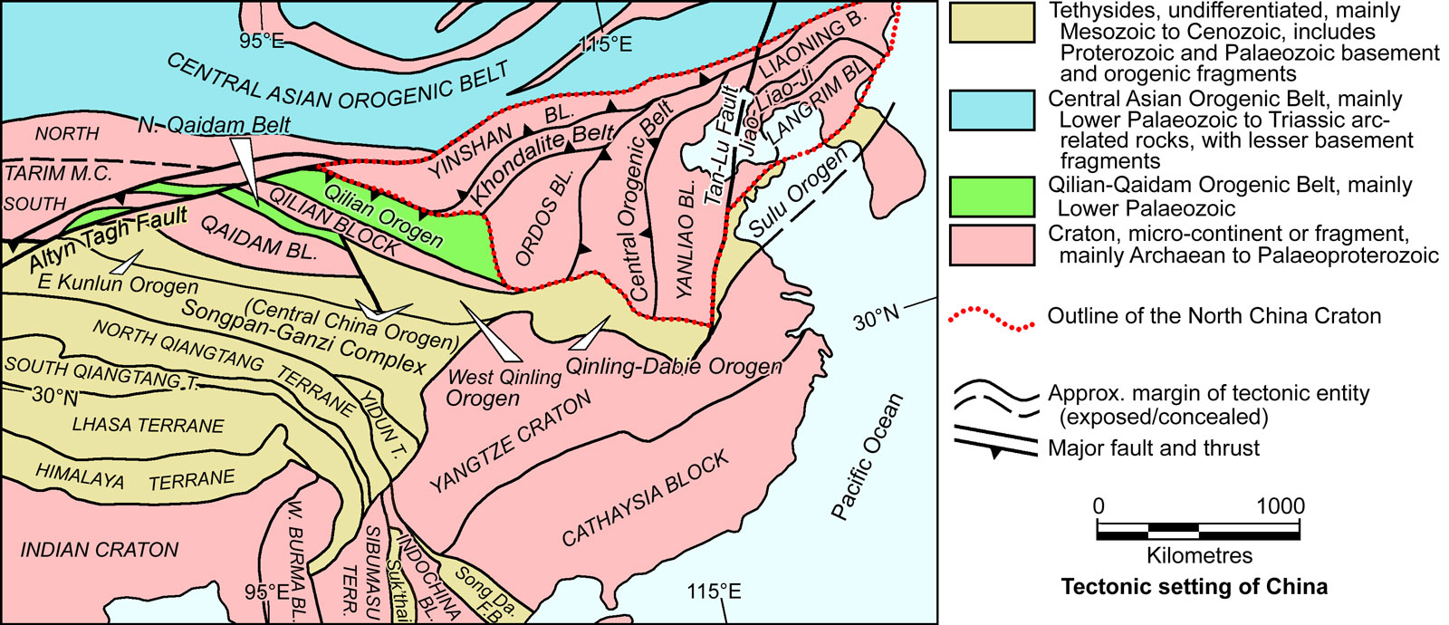
• The closure of the Palaeozoic Palaeo- and Meso-Tethyan Oceans in the Permian to Triassic, and to form a near linear, generally WNW-ESE trending orogen. This orogen is composed of a collage of mostly 'sliver-like' tectonic blocks, each of up to several thousand kilometres in length, that were progressively accreted and sutured to the southern margin of the composite South China Block and Songpan-Garzê Terrane. Each of these micro-continental strips is separated by a volcanic arc and/or suture zone and/or accretionary wedge. These slivers and sutures included, from NE to SW (see the Tectonic Setting image below), after Deng et al. (2019), the:
i). Yidun or Zhongdian Terrane, a ~300 km long, by 15 to 30 km wide wedge-shaped domain that straddles the Songpan-Garze to South China Cratonic Block boundary, and is separated from the North Qiangtang Sub-terrane by the Jinshajiang-Ailaoshan (or 'Jinsha') Suture. The latter is interpreted to be a long-lived, multistage suture, with the first stage reflecting closure of the Jinshajiang (or Proto-Tethys) Ocean which was subducted to the west below the North Qiangtang Sub-terrane until its closure at ~245 Ma (Hou et al., 2003).
ii). laterally contiguous Indochina and Changdu-Simao blocks, the latter of which forms the core of the North Qiangtang Sub-terrane. Both were rifted from the South China Cratonic Block/Cathaysian continent during the Early Ordovician to Middle Devonian, possibly parting along the first stage Jinshajiang-Ailaoshan Suture, to form the intervening Devonian to Triassic Palaeo-Tethys Ocean (e.g., Wang et al., 2018); The closure of this Ocean in the Late Permian formed the second stage in the development of the Jinshajiang-Ailaoshan Suture.
iii). cratonic South Qiangtang Block is best developed to the west, but drastically thins to the east. The North and South Qiangtang blocks/terranes are separated by the Longmu Co-Shuanghu Suture Zone (closed Meso-Tethys Ocean), which passes to the SSE into the Lanchangjiang Fault/Suture separating the composite Changdu-Simao Block (representing the core of the North Qiangtang Terrane) from the South Qiangtang Block to its west. Further south again, the continuing, composite Changdu-Simao-Indochina Block is separated from the Sibumasu Terrane to the west by the Sukhothai Arc, across the Jinghong Suture) that marks its eastern margin of the arc.
The South Qiangtang and Lhasa blocks/terranes are separated by the broad, from <10 to 100 km wide, Bangong Co-Nujiang Suture (also known as the Nijiang-Bitu Suture to the SE). This suture is interpreted to reflect the closing of the Bangong–Nujiang Ocean between the two blocks which opened between 165 and 145 Ma, and began closing and subducting from 165 to 145 Ma, followed by continent-continent collisional orogenesis between 100 and 65 Ma, followed by post-orogenesis (e.g., Song et al,, 2023). As such, the South Qiangtang and Lhasa blocks/terranes would seem to have migrated northward from Gondwana together.
iv). laterally contiguous cratonic Lhasa and Sibumasu (or Shan-Thai) cratonic terranes. The northern, attenuated tip of the Sibumasu Terrane, where it abuts the Simao Sub-terrane across the Lanchangjiang Fault, is known as the Baoshan Sub-terrane.
v). West Burma Cratonic Block that is restricted to the eastern half of the belt (e.g., Deng et al., 2014). The northern extremity of the West Burma Cratonic Block, where it tapers between the India Craton and Lhasa Terrane and Baoshan Sub-terrane/Sibumasu Terrane is known as the Tengchong Sub-block. It is separated from the Sibumasu Terrane by the Luxi Suture, representing an arm of the closed Meso-Tethys Ocean.
Alternatively, the cratonic South Qiangtang Sub-terrane and Sibumasu terranes might be lateral equivalents, whilst the West Burma Block and Lhasa Terrane may be part of the same micro-continental sliver (e.g., Wang et al., 2019). However, the earlier closure of between the Lhasa and South Qiangtang terranes relative to the West Burma and Sibumasu terranes (see below) favours the first option.
Detrital zircon ages and fauna both suggest that the Sibumasu Terrane and South Qiangtang Sub-terrane have Gondwana affinities and may have, closely followed by the Lhasa Terrane, advanced across the Mid Permian to Late Cretaceous Meso-Tethys Ocean to collide with the composite Indochina-Changdu-Simao (North Qiangtang) terranes that were by then accreted to Asia. Most likely, the West Burma Block similarly followed behind, with of the India Plate, across the Late Cretaceous to Mid Cenozoic Neo-Tethys Ocean (e.g., Wang et al., 2019; Sengör, 1984; Metcalfe, 2013). See the Yulong Belt record and the description below for more detail.
• During the closure of the southwest subducting Palaeo-Tethys Ocean below the Indochina Terrane, the major, Late Permian Emeishan Large Igneous Province was erupted, extending from over the Ailaoshan-Red River Shear Zone on the southwestern edge of the Yangtze Craton, and to the NE and east, covering more than 250 000 km2 of the craton. Related intrusions and tectonic slices of this complex are found for >300 km to the SE along the Ailaoshan-Red River Shear Zone.
• An extensional event that overlapped the terminal stages of closure of the Palaeo-Tethyan Ocean to the south, but resulted in the development of a series of long, narrow, connected, possibly diachronous, intracontinental basins. These basins were developed over a strike length of ~1000 km and preserved width of <20 to >80 km, necking to its thinnest opposite the southern section of the Yidun Terrane. They largely correspond to the outline of the underlying Indochina-Changdu-Simao cratonic block, bounded by faults following the structures/sutures that define that block. These are principally the Jinshajiang-Ailaoshan Suture/Shear Zone to the east, while to the west it is bounded by a combination of structures that include the Bangong Co-Nujiang Suture Zone Suture between the South Qiangtang and Lhasa terranes in the north, passing south into the major Lanchangjiang Fault/Suture/Tectonic Belt, and then to the Jinghong Suture (e.g., Liu et al., 2012; Wang et al., 2016) in the south, between the Indochina Block and the Sukhothai Arc (and Sibumasu Block). It is dominantly fringed by older Proterozoic to Late Palaeozoic rocks juxtaposed across these bounding faults, although, locally, the basin sequence strays across these structures, suggesting the current outline represents a down-faulted remnant of a once more extensive basinal sequence. The preserved basins include, from north to south, the Changdu, Lanping (also referred to as the Qamdo) and the Simao basins.
The development of these rift basins, which followed the Mid Permian to Mid Triassic closure of the Palaeo-Tethys Ocean, coincided with Late Triassic post-collisional extension between ~235 to 203 Ma, followed by the development of a Jurassic to Cretaceous sag basin. During the Paleocene to Early Oligocene, these basins were subjected to strong contractional and strike-slip tectonics, the result of the collision of the Indian continent to the south from ~55 Ma (Dupont-Nivet et al., 2010; Najman et al., 2010; Deng et al., 2014; Wang et al., 2015, 2016). This latter Cenozoic tectonism resulted in the formation of relatively wide zones of high grade mylonitic metamorphism, particularly in the Ailaoshan-Red River Shear Zone/Orogen, as detailed below, but also within the Lanchangjiang Suture as the Chongshan Shear Zone on the opposite flank of the Lanping Basin (e.g., Deng et al., 2014).
The Lanping Basin was filled with Mesozoic and Cenozoic strata, mainly continental siliciclastic rocks, except for the lowest part of the sequence and the overlying Upper Triassic Sanhedong Formation, which are mainly composed of marine limestone (Xue et al., 2002, 2007). These Late Triassic carbonates are overlain by the Middle Jurassic Hakaizuo Formation carbonate-bearing sandstone and carbonaceous shale/slate, and the Lower Cretaceous Jingxing Formation terrestrial clastic red bed rocks (e.g., Zhang et al., 2015). Only a few igneous rocks occur within the basin, mainly to the south. These include mantle derived quartz syenite, quartz monzonite porphyry, granitic porphyry and nepheline monzogabbro, with ages ranging from 68 Ma to 23 Ma (Rb–Sr, U–Pb, and Ar–Ar; Dong et al., 2005; Xue et al., 2002; Zhang et al., 2000; Zhao, 2006). Dynamic processes within the basin were controlled by the
trans-lithosphere faults along its margins, and the crust-penetrating faults in the middle, of the basin (Xue et al., 2002; Zhang et al., 2000).
To the north, the Changdu Basin is less well developed and largely comprises a collection of less extensive, fault controlled Tertiary pull-apart basins.
The Simao Basin, which is the southern continuation of, and has a similar sequence to the Lanping Basin, is limited to the south by a ridge controlled to the north-south Dien Bien Phu Fault that cuts the Ailaoshan-Red River Shear zone near the China-Vietnam border. This ridge separates it from the more extensive Khorat Plateau Basin, which overlies and masks most of the Indochina Cratonic Block. It covers an area of 200 000 km2 and comprises a complex sequence of basins formed during five periods of deposition from the Late Carboniferous to the end of the Cretaceous, each separated by unconformities related to major orogenic events (Booth and Sattayarak, 2011). Up to 6000 m of sequence has been preserved. The Upper Carboniferous and Permian succession is predominantly shallow-marine carbonates and shales but includes some clastic deposits. The overlying Mesozoic sequences are predominantly terrestrial sandstones and lacustrine shales, overlain at the top by thick terrestrial red-beds. To the SE of the Dien Bien Phu Fault and NE of the Khorat Plateau, sections of the Ailaoshan-Red River Shear zone and Palaeozoic to Late Triassic sequences were unconformably overlain by the Tu Le Basin succession, which is dominated by Jurassic to Cretaceous volcanic rocks, the lower, middle and upper parts of which are predominantly composed of basalt and andesitic basalt, trachyte and rhyolite, respectively.
• The NE directed impact of the Gondwana related India Craton with the laterally more extensive, linear WNW-ESE aligned East Tethyan Orogen from ~55 Ma. The oceanic crust in advance of the Indian Craton was subducted to the north below the Lhasa and Sibumasu cratonic blocks, and then under the West Burma following its accretion. The protruding northeastern 'horn' of the India Craton collided with the composite East Tethyan Orogen causing it to 'bend', accompanied by intense east-west compression, and the lateral attenuation of the major terranes. This collision resulted in the development of:
i). Three principal broad shear zones that accommodated both large scale thrusting and strike slip displacement, specifically the:
a). Ailaoshan-Red River Shear Zone, that closely follows the Jinshajiang-Ailaoshan Suture as described above, except to the SE, in Vietnam, where the two strutural features diverge and the shear zone traverses the South China cratonic block to the NE of the suture. It encloses four narrow NNW-SSE to NW-SE oriented cores of high-grade metamorphic complexes that are distributed along the strike of the shear and are separated by 'attenuation' gaps. They are mainly composed of mylonitic Mesoproterozoic gneisses, and comprise from north to SE, the Xuelongshan, Diancangshan, Ailaoshan and Day Nui Con Voi Massif massifs, distributed over a length of >1000 km, as discussed in more detail below. These metamorphic rocks exhibit intense ductile deformation with a well-developed foliation and strong sub-horizontal stretching lineation. The most extensive of these massifs, the Ailaoshan, contains pre-shearing granite dated at 36.6 to 30.9 Ma, syn-shearing leucogranite at 27.2 and 25.9 Ma, whilst post-shearing granite dykes are dated at 21.8 Ma; b). Gaoligongshan Shear Zone, following the suture separating the Tengchong Sub-terrane/West Burma Terrane and Baoshan Sub-terrane/Sibumasu Terrane, with four deformational episodes, comprising, firstly, horizontal shearing at ~65 Ma; the second resulting in a narrow ductile zone and crustal partial melting producing leucogranite intrusion between 24.4 to 21 Ma; followed by transpression-induced exhumation and cooling between 17 and 11 Ma; whilst the final stage was east-west extension, most likely between 8.4 and 0.9 Ma; and
c). Chongshan Shear Zone that is >250 km long and ~10 km wide, juxtaposing the Simao-Indochina Block and the Baoshan Sub-terrane/Sibumasu Terrane to the north of the Sukhothai Arc. The shear zone is mainly composed of mylonitic and related gneisses cutting pre-shearing 55 to 38 Ma granites, syn-shearing leucogranite veins with 32.6 to 31.52 Ma zircons that have 32 to 22 Ma growth rims, all of which are cut by post-shearing 17.1 to 16.5 Ma dykes. It is therefore concluded that shearing along the three zones described herein was almost contemporaneously initiated at ~32 Ma (Deng et al., 2014).
ii). Thrust-fold systems developed within the Mesozoic basins between these major shear zones/sutures due to strong Cenozoic compression. This resulted in the Changdu, Lanping and Simao basins being strongly folded and faulted. East and west verging thrusts are found on the western and eastern margins respectively of both the central Lanping and Simao basins, separated by a large, continuous, central north-south trending fault known as the Central axis fault or Lanping-Simao fault. This fault zone comprises a highly variably, but overall west dipping brittle fracture array, in which the planes with shallow dip often cross-cut those with steep attitudes. This fault zone transects Paleogene strata, implying it was developed concomitantly with the ductile shearing in the Ailaoshan-Red River and related shear zones (Liu et al., 2004). Other faults, including offshoots of the Ailaoshan-Red River
shear zone, provide evidence of both strike-slip and thrust movement.
iii). Paleogene and Neogene intra-continental strike-slip extensional basins - Younger Paleogene pull-apart basins developed intermittently across the North Qiangtang/Changdu and Simao blocks, although most are concentrated toward the faulted margins of these cratonic blocks. The best developed are the dextral Gonjo Basin on the eastern side of the Changdu Block (and Yulong Porphyry Belt), and the sinistral Nangqen and Lawu basins, to the north and south respectively, on the western side of the same block. The larger of these basins are 100 to 200 km long and 20 to 30 km wide. They typically comprise Palaeozoic to Triassic basement overlain by generally >2600 m, and locally >4000 m or more of Paleocene to Eocene sedimentary rocks, mainly gypsum-bearing red molasse, that is intercalated with Late Eocene, 42.4 to 37.5 Ma, potassic to ultrapotassic volcanic rocks (Hou et al., 2003; Spurlin et al., 2005; Yang et al., 2013). Three deformation stages have been recognised within these basins in the northern Changdu Basin area, with these pull apart basins marking a transition from early NE-SW contraction, middle sinistral and dextral strike-slip/transtensional faulting, to a later NE-SW contraction (Spurlin et al., 2005). Further south, syndepositional structures are common in these Paleogene basins, whilst in some areas, the basement has been overthrust onto the Cenozoic sediments. Sedimentary relationships within these younger basins adjacent toi the Ailaoshan Shear Zone have been interpreted to indicate shearing began in the Oligocene followed by rapid exhumation that had been initiated by Early Miocene (Schoenbohm et al., 2005).
Ailaoshan-Red River Shear Zone/Orogen
The Ailaoshan-Red River Shear Zone/Orogen is a segment of a larger, complex Eocene to Late Cenozoic and currently active structure that largely follows a suite of earlier faults and sutures dividing a collage of Archaean to Miocene tectonic units into two tectonically displace domains. This larger structure, the Jinshajiang-Ailaoshan-Red River Shear Zone is the core of the >1500 km long Jinshajiang-Ailaoshan-Red River Metallogenic Belt, which incorporates both the Ailaoshan-Red River and Yulong porphyry/mineral belts. To the west, the Jinshajiang-Ailaoshan-Red River Shear zone begins on the Tibetan Plateau, where it trends WNW-ESE and follows the Jinshajiang Suture separating the Songpan-Garze and North Qiangtang terranes to the north and south respectively (see the Tectonic Setting map below). It then curves SE, then NNW-SSE adjacent to the Eocene Yulong Porphyry Belt deposits, which are around 40 km to its SW. Over this interval, it separates the Yidun Terrane and the cratonic Changdu Block, the core of the North Qiangtang Sub-terrane. It then swings to near north-south towards the south of the Yidun Terrane, where it is 50 to 80 km west of the Triassic and Cretaceous porphyry and skarn deposits of that terrane. From the southern tip of the Yidun Terrane, it becomes the Ailaoshan-Red River Shear Zone and forms the southwestern margin of the Yangtze Craton, the north western half of the composite South China Block, which also includes the Cathaysia Block to the SE. In this northern section of the Ailaoshan-Red River Shear Zone, it trends NNW-SSE where it is a few, up to as much as 75 km west of the Eocene porphyry and skarn Cu-Au deposits that form the main cluster at the northern end of the Ailaoshan-Red River Belt. From there the shear zone continues to rotate to trend NW-SE, separating the Yangtze Craton from the Simao Sub-block, which is the southern continuation of the Changdu Block, but also is a fault displaced sliver of the Indochina Cratonic Block. Over ~350 km into this NW-SE trending section, it is joined by the major, near north-south, dextral Dien Bien Phu Fault to the SW, and at much the same point, to the NE, intersects the NE-SW Neoproterozoic Shizong-Mile-Luoping-Luodian Fault, reflecting the suture separating the Yangtze Craton from the Cathaysia Block to its SE. These two cratonic blocks were accreted in the earliest Neoproterozoic. Over this NW-SE segment, the Ailaoshan-Red River Shear Zone comprises a narrow, generally <20 km wide belt of high metamorphic grade mylonitic rocks to the NE, bounded to the SW, by a gradually expanding wedge of thrust imbricated, low metamorphic grade, Neoproterozoic to Triassic volcanic and sedimentary rocks. However, to the SE, across the Dien Bien Phu Fault, this low grade wedge abruptly expands from ~30 km, to be 80 to 100 km wide, whilst the high grade mylonitic zone to the NE remains unchanged. This expanded section of the low grade wedge is occupied by the composite Mid-Palaeozoic to Late Triassic Song Ma and Song Da Rifts and subsequent fold belt, and is less intensely folded and imbricated than the equivalent rocks to the NW of the Dien Bien Phu Fault. It unconformably overlies Proterozoic basement of the Cathaysia Block. The Triassic suture between the Simao Sub-block of the Indochina Cratonic Block and the Yangtze Craton to the NW of the Dien Bien Phu Fault, is interpreted to correspond to the SW margin of the high grade mylonitic section of the shear zone. To the SE, that same suture appears to diverge from the high metamorphic grade mylonitic Ailaoshan-Red River Shear Zone to follow the southwestern subducted margin of the 'Cathaysia floored' Song Ma Rift, juxtaposing the latter with the main Indochina Cratonic Block. However, the high grade, mylonitic northeastern margin of the shear zone crosses the Dien Bien Phu Fault without significant offset and passes into the Cathaysia Block of the composite South China Block. It remains within the Cathaysia Block, trending NW-SE, parallel to the sutured boundary between the Indochina Cratonic Block and the Song Ma Rift. Whilst the Triassic suture marks the collision of the South China and the composite Indochina blocks, offset by the Dien Bien Phu Fault, the high grade, mylonitic section of the Ailaoshan-Red River Shear Zone represents Early to Cenozoic thrusting, post-tectonic relaxation and large scale strike-slip faulting that was initially sinistral, now dextral. That younger, post-Dien Bien Phu Fault Early to Late Cenozoic tectonism follows and overprints the Triassic suture to the NW of the Dien Bien Phu Fault, but to the SE the two zones of tectonism are spatially separated. The southern cluster of porphyry-skarn and porphyry Cu-Au, orogenic Au, disseminated Au, IOCG Cu-Au and sulphide Ni deposits within the shear zone are largely clustered in a knot straddling the intersection between the Ailaoshan-Red River Shear Zone and the Dien Bien Phu Fault to the SW and the suture between the Yangtze and Cathaysia blocks to the NE. These deposits range from being within the mylonitic shear zone to ~30 km to its south within the low metamorphic grade wedge. However, significant gold deposits are also strung out over an interval of ~200 km to the NW.
The Ailaoshan-Red River Fault/Shear Zone is currently a dextral transform fault that for >1000 km straddles a string of four, long, narrow, generally <20 km wide high-grade gneiss massifs distributed end to end over its length, separated by narrow 'attenuation' gaps along strike. These are, from NW to SE, the Xuelongshan, Diancangshan and Ailaoshan massifs in Yunnan, and the Day Nui Con Voi Massif in Vietnam. The first two are relatively short, being ~40 and 100 km long respectively and lie within the north-south section of the shear-zone/orogen. Studies of at least two of these have shown that during the interval between 26.3 and 22.4 Ma in the Miocene, they underwent intense, progressive sinistral shear under amphibolite-facies, 3 to 7 kb and 550 to 780°C conditions, accompanied by the emplacement of coeval leucocratic melts. The cumulative offset on the shear zone is estimated to have been of the order of 700 ±200 km (e.g., Leloup et al., 1995, 2001), although Mazur et al. (2012) calculate a sinistral offset of ~250 km. The mylonites in the Ailaoshan and Diancangshan ranges are indicated to have rapidly cooled to ~300°C between 22 and 17 Ma, prior to the termination of sinistral translation and the beginning of dextral strike-slip displacement.
The Ailaoshan Shear Zone/Orogen will be discussed in two parts below. The first being the long, but relatively narrow section in Yunan, China, particularly the segment that straddles the Ailaoshan Massif where shearing and metamorphism is localised to a width of generally <10 km, but expanding to ~30 km in the SE. Over this interval, the Ailaoshan-Red River Fault/Shear Zone closely follows the Permo-Triassic Ailaoshan Suture separating the Simao Sub-block of the Indochina Cratonic Block. This interval is dominated by the oblique advance and collision between the north-eastern horn of the India Craton with South China cratonic Block with only a narrow intervening attenuated slivers of the Simao-Changdu Sub-block and Sibumasu-Lhasa Terrane. The second, part will address the segment further to the SE, in northern Vietnam, Laos and Myanma, influenced by the presence of the Indochina and adjacent cratonic blocks between the India and South China cratonic blocks. This second segment represents a broader, up to 120 km wide belt, dominated by the Late Palaeozoic to Mesozoic approach and collision of the Indochina and Sibumasu cratonic blocks and their accretion onto the South China Block. This was followed by the Cenozoic thrusting and large scale strike slip dislocation along the Ailaoshan-Red River Shear Zone initiated by the collision of the India Plate to the west, similar to that discussed in the first part.
Ailaoshan-Red River Shear Zone/Orogen in China
The Ailaoshan Massif, which is the longest of the four linear high-grade gneiss massifs detailed above, extends over a length of >350 km, from south of the Yidun Terrane in the NW, to the Song Da-Song Ma Fold Belt in Vietnam (see image above). The high grade metamorphic rocks of the Ailaoshan Massif are bounded to the SW by a low-metamorphic grade zone (Yang et al., 2023). The composite high and low grade metamorphic zones take on a SE expanding wedge shape, commencing from the point where the Ailaoshan Shear Zone changes trend from north-south to NW-SE, and follows the SW margin of the Yangtze Craton. The distribution of high and low grade facies within the composite metamorphic zone is controlled by three major NW striking and 60 to 80° NE dipping shears with reverse as well as strike-slip displacement. The high-grade metamorphic sequence (the Ailaoshan Group) lies between the Red-River and Ailaoshan shears (to the NE and SW respectively). It is dominated by up to amphibolite-granulite facies, comprising an assemblage of paragneiss and granitic gneiss, with lenses of marble, amphibolite and garnet pyroxenite, and thin layers of hornblende-schist. Granite was emplaced at ~800, 250 and ~30 Ma (Lin et al., 2012; Qi et al., 2012; Liu et al., 2015).
The Red River Shear to the NE, separates the Ailaoshan Group high grade metamorphic complex from the up to 10 km thick, mid-Neoproterozoic to Eocene para-platform cover sequence masking the Yangtze Craton of the South China Block.
The low-grade, SE expanding, tectonic wedge to the SW of the Ailaoshan Shear is bounded to the SW by the third of these structures, the Jiujia-Anding (also known as the Jiujia-Mojiang) Shear. It is composed of lowermost greenschist facies metasedimentary sequences, comprising Proterozoic basement overlain by Ordovician turbidites, impure Silurian carbonates, and Devonian carbonates and carbonaceous slates. These were followed by Triassic volcanic rocks, partially separated by Devono-Carboniferous ophiolite fragments (Shen et al., 1998; Zhong, 2000). The ophiolitic fragments include, from bottom to top, serpentinised peridotites, a gabbro-dolerite association, marine basalt, and sedimentary rocks, that possibly reflect the Permo-Triassic Ailaoshan Suture Zone between Indochina and the South China Block (e.g., Wang et al., 2022). The low metamorphic suite is >200 km long, and ranges from <1 km in width in the NW, to >30 km at the China-Vietnam border to the SE. Between the Ailaoshan and Jiujia-Anding shears, the low metamorphic grade sequences lie within a SW vergent frontal thrust belt composed of a series of nappes. The bounding thrusts between these nappes strike NW to NNW, oblique to the NW trending Ailaoshan and Jiujia-Anding shears that limit them to the north and south. This structural setting defines three lense shaped nappes, which are from east to west, the:
• Jinping Nappe, which structurally overlies the basement Ailaoshan Group high grade metamorphic rocks outcropping to the NE. It is composed of Early Palaeozoic clastic and carbonate rocks, including Lower Ordovician sandtone and siltstone, Devonian dolostone, limestone, chert and carbonaceous slate, and Silurian to Permian dolomitic limestone, dolostone and limestone. These are overlain by lesser Late Triassic metasedimentary rocks, together with basalt of the ~260 Ma Permian Emeishan large igneous province (Chung et al., 1997). These rocks are intruded in the NE, adjacent to the Ailaoshan Shear, by Devonian to Carboniferous diorite and monzonite, Triassic granite and mid-Jurassic to earliest Cretaceous granite and monzogranite (e.g., Zhang et al., 2017). The nappe is bounded to the north and NE by the Ailaoshan Shear, and to the SW by the Tengtiaohe Thrust/Shear, and contains many of the porphyry and gold deposits of the southern cluster of the Ailaoshan-Red River Metallogenic Belt.
• Lvchun Nappe, which structurally overlies the Jinping Nappe across the Tengtiaohe Thrust and is composed of Late Palaeozoic, mainly Carboniferous to Permian, volcanic and sedimentary rocks covered by a Triassic volcano-sedimentary sequence. It is bound to the north by the Ailaoshan Shear and to the south by the Jiujia-Anding shear.
• Jinshan Nappe, to the west of the Lvchun Nappe, which it overlies, across another NNW trending and ENE dipping thrust. It is predominantly composed of low grade Palaeozoic rocks, and is bounded to the NE by a thrust which merges with the Ailaoshan Shear to the NW, which then bounds the nappe. To the SW it is limited by a Devono-Carboniferous tectonic melánge that is developed in the hanging wall of the Jiujia-Anding shear.
Immediately to the west of the Jiujia-Mojiang fault, a long narrow foreland basin is developed, primarily composed of Carboniferous sedimentary rocks, overlain by Upper Triassic molasse, and structurally succeeded by the Sanmeng Nappe that is primarily composed of Palaeozoic strata. To the south, these sequences overlie the northern margin of the Simao Terrane of the Indochina Block. Gold deposits are hosted within the tectonic melánge in the hanging wall of the Jiujia-Anding shear and the Jinshan Nappe, while smaller occurrences occur in the Lvchun and Sanmeng nappes in the south.
Evolution - According to Yang et al. (2023), the wedge of metamorphic rocks that constitutes the Ailaoshan Massif, as described above, are the product of a multistage tectonic evolution on the margin of the Yangtze Craton, from the assembly of Rodinia, through the Neoproterozoic, and then the Palaeozoic to Triassic opening and closure of the Palaeo-Tethyan Ocean, to Cenozoic intracontinental imbrication and shearing related to the continent-continent collision between India and Asia to the SW (Wang et al., 2020; 2021).
Meso- to Neoproterozoic activity involved development of subduction-related magmatic arcs (Cai et al., 2014; Zhao et al., 2018). Nakano et al. (2021) suggest this involved 'southwest' subduction of a Proto-Tethyan Ocean below an exotic Proto-Indochina Cratonic Block approaching from the SW. This activity produced Mesoproterozoic mafic and felsic rocks, and following collision and amalgamation with the Proto-Yangtze Craton, deposition of Neoproterozoic sedimentary rocks in overlying foreland basins. Deposition of Ordovician through Silurian to Triassic sedimentary rocks ensued within the Jinshajiang-Ailaoshan or Palaeo-Tethys Ocean that stretched from NW of the Yulong Belt to the South China Sea. This ocean was the result of rifting of the sliver-like, composite, Indochina-Simao-Changdu (North Qiangtang) microcontinent from the Proto-Yangtze Craton, likely parting along the earlier Proterozoic collision suture related to the Proto-Tethyan Ocean closure proposed above (Nakano et al., 2021). According to Liu et al. (2012), from ~400 Ma in the Devonian, non-volcanic rifting is indicated, followed by sea floor spreading to produce what are now the preserved ~387 to 377 Ma Ailaoshan Ophiolites and ~359 to 345 Ma rift volcanics. A further, late phase sea floor spreading is indicated by the ~346 to 341 Ma Jinshajiang Ophiolites to the north. Both of these now dismembered sutures include well preserved mid-ocean ridge basalt (MORB) with serpentinite, meta-peridotite, gabbroic cumulates, dolerite dykes and radiolarian cherts being well preserved (Mo et al., 1998; Metcalfe, 2006; Yumul et al., 2008; Jian et al., 2009).
This spreading and deposition ended with inversion and reversal, leading to NE-directed subduction of the Palaeo-Tethyan oceanic crust below the Yangtze Craton/South China Block. This produced arc magmatism during the Mid to Late Permian (Nakano et al., 2021; Fan et al., 2010; Liu et al., 2015; Yang et al., 2018). This arc was developed on the NE margin of the Indochina Cratonic Block, which was amalgamated onto the South China Block to produce a series of NE-vergent folds and regional NW-striking thrusts (Yeh et al., 2008; Faure et al., 2016). Continued subduction resulted in the granulite facies metamorphism of pre-Late Triassic continental rocks of the following Indochina Plate as they too were subducted (Liu et al., 2013). The subsequent Late Triassic post-collision extension exhumed these high grade rocks, whilst also triggering bimodal mafic and felsic magmatism in a series of extensional basins (Liu et al., 2015; Yang et al., 2018).
Superimposed on this pattern is the outpouring of the ~260 Ma and younger, Mid to Late Permian, >250 000 km2 Emeishan large igneous province, which ranges from ~5 km in thickness to the west, to <100 m in the east (He et al., 2007). As such, they may have emanated from the the Ailaoshan-Red River Shear Zone along their west to SW margin. They overlie limestone dominated Middle Permian rocks, and are, in turn, covered by Upper Permian clastic rocks in the east, and Lower Triassic sedimentary rocks in the west (He et al., 2007). They comprises voluminous low-Ti and high-Ti basalts, picrites, ultramafic-mafic intrusions, granites and alkaline intrusions, as well as silicic volcanic rocks, and are postulated to be the product of an impinging mantle plume.
The closure of the Palaeo-Tethyan Ocean, and extrusion of the Emeishan LIP, were followed by the approach from the south to SW of the Gondwanan South Qiangtang, Lhasa and Sibumasu linear microcontinents and the closure of the intervening Meso-Tethyan Ocean, culminating in the accretion of these blocks to the growing amalgamated Asian Plate.
This was followed by the progressive closure of the Neo-Tethyan Ocean between the India Cratonic Block in the south and the amalgamated Asian Plate, which occurred from ~65 Ma in the central Tibetan Plateau, to ~56 to 50 Ma in the east, following the oblique collision between the West Burma and Sibumasu blocks and then the subduction of India below the West Burma Terrane (Ding et al., 2005). The north to NE- to east dipping oceanic slab in advance of the Indian Continental Block that was subducting below the amalgamated Asian Plate, is postulated to have been detached at ~45 to 40 Ma (Xu et al., 2008; Deng et al., 2014; Ji et al., 2016). This was followed by continued contraction resulting in crustal anatexis between 44 and 28 Ma (Liu et al., 2013; Li et al., 2021) as the Indian Continental Plate/Block was also thrust below both the Lhasa and West Burma terranes of the amalgamated Asian Plate. The stresses involved in this collision were absorbed in part through distal strike-slip shearing, thrust imbrication and metamorphism along the Ailaoshan-Red River Shear Zone, as reflected by U-Pb zircon rim ages from foliated migmatites and leucogranites in the Ailaoshan Group high-grade metamorphic belt. This then progressed from peak amphibolite-granulite facies at ~44 to 36 Ma, through near-isothermal decompression at ~32 to 25 Ma, to retrograde metamorphism at ~25 to 14 Ma (Liu et al., 2013; 2015; Wang, F., et al., 2016; Yang et al., 2023 ). Within the Ailaoshan Massif, the Ailaoshan-Red River Shear Zone that accommodated these stresses appears to have followed and reactivated the earlier Permo-Triassic Ailaoshan Suture that separated the Yangtze and Indochina cratonic blocks (Liu et al., 2012).
A series of alkali-rich porphyry and lamprophyre dykes were intruded into the Jinping and neighbouring nappes, interpreted to having been formed during the early post-slab break-off stage between ~38 and 32 Ma, prior to exhumation. They are believed to be the product of melting of the lower crust and enriched mantle, respectively (Wang et al., 2001; Lu et al., 2013; Deng et al., 2017; Dong et al., 2021; Xuet al., 2021).
The subsequent evolution of the stress field was the product of tectonic rebound along the subduction front following slab detachment and the interval of continued contraction, followed by consequent exhumation of the subducted continental crust. Similarly, relaxation of the stress field led to exhumation of underthrust, imbricated crust along the Ailaoshan-Red River Shear Zone. Exhumation of the Ailaoshan high-grade metamorphic belt is interpreted to have commenced at ~31 Ma (Palin et al., 2013), with two rapid cooling phases at ~27 to 17 and ~14 to 13 Ma (zircon U-Th-He and apatite fission-track dating; Wang, Y., et al., 2016). Large-scale sinistral ductile shear displacement of 500 to 700 km is indicated along the Ailaoshan Shear Zone, between 31 and 22 Ma (Chung et al., 1997; Searle et al., 2010; Cao et al., 2011; Liu et al., 2015). This period of rebound and extension corresponds to the sinistral sense of displacement on the Ailaoshan Shear Zone, in contrast to the dextral motion expected during the approach of the Indian Cratonic Block from the south.
According to Sun et al. (2022), the extreme tectonic activity during this approach and collision of India and Asia and the subsequent rebound has resulted in a relatively chaotic stratigraphic succession, with extensive Cenozoic magmatic rocks dominating. The influence of the oblique Himalayan Orogeny during the Eocene to early Oligocene resulted in the large-scale shearing along the Ailaoshan-Red River Tectonic Belt, accompanied by development of voluminous potassic magma forming the ~41 to 32 Ma igneous belt. The felsic intrusive bodies of this event mainly occur as syenite porphyry, adakitic granite and quartz monzonite, with the end-members generally characterised by high silicon, potassium, sodium and calcium, closely related to a series of Cu-Au-Mo deposits in the area. During the late Oligocene to early Miocene, the tectonic regime changed from shear to a regional extensional environment, and potassium-rich calc-alkalic magmatic rocks were mainly developed.
The significant disseminated gold deposits listed at the top of this record, Zhenyuan (67.3 tonnes of Au; inclusive of Donggualin with 45 t of Au at a grade of 5.10 g/t Au), Jinchang/Mojiang (32 t of Au with a grade of 2.69 g/t Au), Chang'an (40 t of Au at a grade of 5.84 g/t Au) and the orogenic lode-type Daping (60 t of Au at a grade of 14.3 g/t Au), plus eight more medium-sized, and numerous small gold occurrences, all occur within the low-metamorphic grade zone of the Ailaoshan Belt (Sun et al., 2006, 2007, 2009; Deng et al., 2013; Zhao et al., 2013; Zhang et al., 2014). NOTE: Resource/reserve tonnages of contained gold listed above are from Wang et al. (2022) and Yang et al. (2023). The intersections of NW striking brittle shear zones and nearly east-west thrusts control the localisation of these deposits (Hou et al., 2007; Deng et al., 2014).
Some estimates of the age of gold mineralisation have proved contradictory. Biotite from altered lamprophyres at the Zhenyuan deposit have plateau ages of ~26 Ma (Ar-Ar; Wang et al., 2001), whilst palaeomagnetic data of gold ores and altered wall rocks at Zhenyuan and Chang'an suggest mineralisation was between ~23 and 21 Ma (Gao et al., 2018). However, the bulk of the economically significant disseminated gold deposits are indicated to have formed at ~23 to 21 Ma, as reviewed by Wang et al. (2020). Sericite at Daping has yielded an age of 33.76 ±0.65 Ma (Ar-Ar plateau; Sun et al., 2009), although this is inconsistent with field evidence that the lode is cut by a granodiorite dyke dated at 36.74 ±0.29 Ma (U-Pb zircon; Zhang et al., 2018), whilst another determination of gold-related hydrothermal sericite at the Daping and Xiachahe gold deposits has also been dated at ~46 to 42 Ma (Ar-Ar; Yang et al., 2020, 2021).
Ailaoshan-Red River Shear Zone/Orogen and adjacent tectonic entities in Vietnam, Laos and Myanma
Close to the Vietnam-China border, the major, NNE-SSW trending, ~500 km long Dien Bien Phu Fault approaches, and curves to the NW towards, but does not connect directly to the NW-SE aligned Ailaoshan Shear (Doung et al, 2021). The Dien Bien Phu Fault has a dextral sense of displacement and truncates the regional NW-SE Jiajiu-Mojiang Fault that forms the southern margin of the wedge of low grade metamorphic rocks in the SW of the Ailaoshan Massif, and cuts across those metamorphic rocks. To the SE of the Dien Bien Phu Fault, that wedge of low grade metamorphic rocks expands from a width of ~30 km on the Chinese side of the border in the NW, to become the 80 to 100 km wide 'Song Ma-Song Da Mobile Belt' to the SE. This mobile belt persists to the SE, into the South China Sea, and separates the South China and Indochina cratonic blocks.
The adjacent South China Block to the NE, comprises a Palaeo- to Mesoproterozoic high-grade metamorphic basement, largely masked by Neoproterozoic to Mid Triassic marine facies sedimentary cover and Late Triassic to Neogene terrestrial sedimentation. The Indochina Block to the SW is composed of Archaean to Proterozoic high-grade metamorphic basement, overlain by late Palaeozoic and Early Mesozoic shallow marine sedimentary rocks, and late Mesozoic and Cenozoic terrestrial deposits.
The intervening terranes between these two blocks comprise, from the South China Block in the NE, across the Song Chay Fault, to the high grade metamorphic rocks of the Day Nui Con Voi Massif. The Song Chay Fault is developed parallel to, and ~10 to 15 km NE of the Red River Fault across which, the Day Nui Con Voi Massif is juxtaposed with the tapering southeastern extremity of the similarly strongly metamorphosed Ailaoshan Massif. As described above, both massifs are characterised by a highly deformed, metamorphosed and mylonitised regime related to the Ailaoshan-Red River Shear Zone. This shear-mylonite regime overprints both the South China Block and less intensely metamorphosed Palaeozoic sequences of the Phan Si Pan (Phanxipan) - Song Hong Terrane which is in fault contact to the SW of the Ailaoshan Massif. The latter terrane is, in turn, in fault contact further to the SW with the Permo-Triassic volcanic and volcaniclastic sequence of the Song Da Rift Zone that occupies much of the mobile belt. Song Da rifting commenced in the early Permian, forming the carbonate assemblage of the Da Mai formation, overlain by mafic-ultramafic komatiitic volcanic rocks. Rift-related deposition continued until the late Triassic. The sequence also includes the Late Permian Cam Thuy Formation volcanic sequence that comprises andesite-basalt to picrite-andesite-basalt, overlain by the Early Triassic Vien Nam Formation andesite-basalt-komatiite association. Mid- to Late-Triassic sedimentary units included numerous interbedded calc-sediments and calc-alkaline felsic volcanic rocks. Most of the volcanic rocks in the Song Da rift are interpreted to have rift-related characteristics (e.g., Poliakov et al, 1991). Inversion, resulting in contraction and oceanic plate subduction along the southwestern Song Da margin dominated from the early Late Triassic to the Late Triassic.
To the SW again, the Song Da Rift is bounded by the Lower Palaeozoic, mainly mafic volcanic and volcaniclastic rocks of the Song Ma Terrane which rest on Proterozoic to Cambrian basement of the partially intervening Nam Co Complex. The latter is interpreted to represent the near leading edge of the South China Block. The Song Ma Terrane includes large lenses of tectonic mélange and dunite, gabbro intrusives and basaltic extrusives related to the Song Ma Suture which is interpreted to represent the Permo-Triassic South China-Indochina plate boundary. The mafic rocks of this suite have MORB (Mid Ocean Ridge Basalt) geochemical affinities, and protolith ages of ~387 to 313 Ma (Vuong et al., 2013; Zhang et al., 2013, 2014), taken to indicate Palaeo-Tethys oceanic spreading during the Late Devonian to Carboniferous (Hou, et al., 2019).
This suture zone is bounded to the SW by the major sinistral, strike-slip Song Ma Fault which marks the southwestern margin of the Song Ma Rift/Terrane. The tectonic mélange of the terrane includes blocks of Neoproterozoic to Lower Triassic rocks. Composite granite batholiths are also exposed within the same terrane, and along the northeastern margin of the fold belt, variously including those emplaced in the Proterozoic, Late Palaeozoic, Permo-Triassic and voluminous Palaeogene intrusions. In the centre of the fold belt, the Song Da Terrane is overlain by little deformed Cretaceous to Miocene felsic volcano-sedimentary rocks of the Tu Le Rift/Terrane. For more detail and a geological map, see the Setting section of the record describing the Sin Quyen IOCG deposit, which is located within a few hundred metres of the Red River Fault, within high grade metamorphic hosts of the Day Nui Con Voi/Ailaoshan Massif.
Immediately to the SW of the Song Ma Fault and Suture, the NW-SE trending Truong Son composite, ~317 to 202 Ma granitoid arc (e.g., Hou et al., 2019) and overlying, temporally equivalent Song Ca Volcanic Arc are developed, intruding and overlying Proterozoic to Palaeozoic rocks on the northern margin of the Indochina cratonic block. The Truong Son intrusive complex is dominated by early porphyritic biotite granite and biotite-hornblende granite, and a second phase of porphyritic granodiorite and quartz diorite (e.g., Liu et al., 2012). Hou et al. (2019) divide magmatism within the Truong Son arc into: i). an early Late Carboniferous to Late Permian, 317 to 270 Ma subduction related suite of Hf depleted, high-Mg#, sodic, metaluminous I-type granitoids and volcanic equivalents, followed by a pause between ~270 and 263 Ma; ii). a second pulse during the Late Permian to Middle Triassic, from 262 to 235 Ma, marking a progression from metaluminous I-type granitoids to abundant S-type, Hf enriched, low-Mg#, potassic, peraluminous granitoids, corresponding to the tectonic transition from subduction to initial collision; iii). a final phase of metaluminous, high-K, mildly Hf depleted, ±high Mg#, I-type granitoids between 234 and 202 Ma in the late Triassic, possible emplaced during post-collisional extension.
The Song Ca Volcanic Arc is regarded to be a temporal equivalent of the rocks of the Song Da Terrane, and include Permo-Triassic calc-alkaline volcanic andesite, andesitic basalt, dacite, rhyolitic dacite and rhyolite, dated at 270 to 248 Ma (40Ar/39Ar); Lan et al., 2003).
The granitoids and sub-volcanic intrusive rocks of the Truong Son magmatic arc occur as two parallel, NW-SE trending strings of scattered, elongated, 10 to 70 km long intrusions distributed over a width of ~50 km in each string. The northern string is mainly confined between the Song Ma and sub-parallel Song Ca faults, the latter being 50 to 90 km to the SW of the former, although most exposures are immediately adjacent to, and parallel the Song Ma Fault. These intrusions are predominantly composed of deformed calc-alkaline gabbros and granitoids with continental andesite-dacite sub-volcanic rocks. This arc also includes several Early Permian to Late Triassic felsic complexes that comprise diorite, granodiorite and granite with associated rhyolites and volcanic breccia units. The southern string is similarly bound by the Song Ca Fault to the NE and the Po Ko Fault to the SW, and are composed of diorite porphyry, granodiorite and granite porphyry, whereas the main sub-volcanic rock types are andesite, rhyodacitic porphyry and crystal-rich volcanic breccia. These intermediate to felsic magmatic rocks were mainly emplaced between the Late Carboniferous and Early Triassic and where intruded into Carboniferous to Permian carbonate units have produced skarn-magnetite, porphyry-skarn Cu-Au and disseminated gold deposits (e.g.,
Sepon,
Phu Bia - Phu Kham and Ban Houayxai).
To the west, these three major structures, the Song Ma, Song Ca and Po Ko faults, as well as the Truong Son Terrane/magmatic arc are all truncated by the NNE-SSW Dien Bien Phu Fault which juxtaposes the Simao Cratonic Block to the west. The Simao Sub-block is interpreted to be a fault displaced sliver of the western Indochina Cratonic Block (e.g., Wang et al., 2014).
The Simao Sub-block would appear to have been displaced relative to the Indochina Block prior to, or during the collision between the South China and Indochina blocks. As detailed above, the suture between the South China and Indochina blocks is interpreted to be reflected by the Song Ma Terrane/Suture to the east of the Dien Bien Phu Fault in northern Vietnam, now some ~80 to 100 km SW of the Ailaoshan Shear. In contrast, to the west, the suture between the South China and Simao/Indochina blocks is interpreted to curve abruptly across and along the Dien Bien Phu Fault, and continue as the Tengtiaohe Fault which is <30 km SW of the Ailaoshan Shear, with which it converges and merges into, less than 200 km to the NW. Detrital zircon dating indicates closure on this section of the suture took place in the early Late Triassic (Xu et al., 2019).
To the south and SW of the Song Ma Fault, a westward traverse from the Truong Son Terrane/magmatic arc passes over the underlying Indochina Block (which is almost completely masked by the thick cover sequence of the Khorat Plateau Basin), before crossing the Dien Bien Phu Fault onto the similarly masked, north-south trending Simao Sub-block. Large parts of this latter sub-block are overlain and intruded by magmatic rocks of the similarly north-south trending, overlying Loei Arc/Fold Belt that also locally extends across the Dien Bien Phu Fault to lap onto the western margin of the main Indochina Block. The development of this arc reflects two pulses of tectonic activity: i). the east dipping subduction of the early Meso-Tethys Ocean from ~450 to 400 Ma (Shi et al., 2021) in the Ordovician to Early Devonian, accommodating the advance of the Sibumasu Cratonic Block from the west; and ii). renewed eastward subduction of section of the same Meso-Tethys Oceanic crust, but which by then was the Loei-Luang backarc basin to the intra-oceanic Sukhothai Arc that had developed in the eastern Meso-Tethyan Ocean. This latter subduction persisted from 250 to 237 Ma in the Late Devonian to Mid-Triassic (Shi et al., 2021). This backarc basin separated the combined Indochina Block and Simao Sub-block from the intra-oceanic Sukhothai Arc that had developed from the Late Devonian above the main east-dipping Meso-Tethys oceanic plate, accommodating the continued advance of the Sibumasu Cratonic Block from the west. By the Late Triassic, when the Song Ma Ocean and Song Da rift basin had both closed on the eastern margin of the composite Indochina Block, that latter block, the overlying Loei Arc, the Sukhothai Arc and the Sibumasu Cratonic Block had all progressively collided, been amalgamated into the growing Asian Plate, and were bordered to the west by the Neo-Tethys Ocean, across which the West Burma Block and India Craton were both advancing.
The West Burma Block appears to have collided with Sibumasu Terrane, by then part of the amalgamated Asian Plate along a major transform fault after the earliest late Eocene and by the early Oligocene. This is based on the first arrival of Asian detritus into the Central Myanmar Basin that overlies the West Burma Block during that period (Najman et al., 2022). This is also supported by a low temperature thermochronological study of the Indo-Burman Ranges which indicates exhumation and collision in the early-mid Eocene and around the Oligo-Miocene boundary (Najman et al., 2022). Similarly, palaeomagnetic data suggest coupling of the West Burma Block with NE India and subsequent encounter of the former block with Asia along a transform margin during the latest Eocene or Oligocene (Morely et al., 2021).
In the intervening period between the collision of the i). Sibumasu and ii). West Burma blocks with the Asian Plate, the region had undergone extension with the continued development of the Khorat Plateau Basin over the Indochina Block, whilst the Song Da rift sequence was overlain by the Jurassic to Cretaceous intra-continental Tu Le Basin sequence, as described in the Regional and Continental Setting section above.
Evolution - Liu et al. (2012) and Shi et al. (2021) and others cited below interpret the Proterozoic to Cenozoic tectonic activity involving the South China, Indochina and Sibumasu blocks, and intervening terranes, in Vietnam, Laos and Myanma to represent the following succession of events.
• During the Meso- to Neoproterozoic and Cambrian, a very similar tectonic history appears to have applied as described for the Chinese section above, namely, the approach of the same exotic, linear, Proto-Indochina Cratonic Block from the SW, subducting a Proto-Tethyan Ocean below its leading, 'northeastern' edge, upon which a magmatic arc was built. This culminated in collision with the Proto-Yangtze Craton to the NW in China, and deposition of Neoproterozoic sedimentary succession in overlying foreland basins. However, to the SE of the Chinese border with Vietnam, Nakano, et al. (2021) suggests this collision did not occur until the Silurian after the Proto-Tethyan subduction had flipped to produce a Lower Palaeozoic magmatic arc on the leading edge of the South China Block (i.e., the combined Yangtze Craton and Cathaysia Block which were amalgamated in the early Neoproterozoic).
• Between the Ordovician and Silurian, the early Meso-Tethys Ocean crust to the west also began to subduct below the western Indochina Block ahead of the Gondwanan Sibumasu Cratonic Block, which was advancing from the distant 'west to SW'. This produced the first magmatic pulse of the Loei Magmatic Arc on the leading, 'western' edge of the Indochina Block between 450 and 400 Ma (Shi et al., 2021).
• During the Late Devonian and continuing to the Middle Permian, the intra-oceanic Sukhothai Magmatic Arc was developed to the 'west', in the Meso-Tethys Ocean between the Sibumasu and Indochina blocks. It was separated from the former by the Meso-Tethys Ocean, the floor of which was being subducted to the east below the Sukhothai Arc. In the east it was separated from the Indochina Block by the Loei-Luang Prebang-Nan back-arc basin which had been the eastern part of the early Meso-Tethys Ocean, but was actively spreading between 361 and 265 Ma (Shi et al., 2021). Over much the same period, as the latter back-arc basin was spreading, subduction of the late Proto-Tethys Ocean below South China to the 'NE' ceased, and a rift opened between the Indochina and South China blocks to form the Song Ma Rift, an arm of the Palaeo-Tethys Ocean. This expanding ocean was floored by Late Devonian to Carboniferous MORB and was filled by Mid to Upper Palaeozoic sedimentary sequences (Liu et al., 2012).
• During the late Permian, at much the same time as extension in Loei-Luang Prebang-Nan back-arc basin and the Song Ma/Palaeo-Tethys Ocean was waning and inversion commencing, the Emeishan Large Igneous Province (LIP; Ali et al., 2005; Zhang et al., 2006) was being 'poured out' between ~263 and 257 Ma (e.g., Shellnutt, 2004). This LIP, which was most likely 'plume-related', overlaps the Ailaoshan-Red River Shear Zone to the SW, and extends to the NE where it covers >250 000 km2 of the immediately adjacent southwestern Yangtze Craton (Courtillot, 1999; Xu et al., 2004) with a 200 to 5000 m thick sheet of bi-modal ultramafic to syenitic and felsic volcanic rocks (e.g., Shellnutt, 2004). Intrusions within this LIP contain sulphide nickel mineralisation, e.g., the Baimazhai deposit.
• During the late Permian to Mid Triassic, whilst the Meso-Tethys Ocean continued to subduct below, and build the intra-oceanic Sukhothai Arc, expansion of the Loei-Luang Prebang-Nan back-arc basin was inverted and it began to subduct below the 'western' margin of the Simao Sub-block of the Indochina Block to significantly build upon the Loei Magmatic Arc as a second pulse of magmatic activity between ~250 and 237 Ma (Shi et al., 2021).
Extension in the Song Ma Ocean to the 'NE' was also inverted and began to subduct to the 'SW' below the Indochina Block and build the Truong Son Magmatic Arc. This arc was developed on the leading, 'northeastern' edge of the Indochina Block and comprises the Truong Son granitoid and Song Ca volcanic arcs (Liu et al., 2012). This subduction phase occurred in two pulses, an earlier calc-alkaline volcano-plutonic association between ~280 and 270 Ma, whilst the second took place between ~250 and 245 Ma (coeval with the Loei Magmatic Arc second pulse) and was characterised by early to syn-collision peraluminous granite. These pulses are reflected by the ages of the voluminous granitoids of the Truong Son Magmatic Arc. The second pulse was followed by continent-continent collision from 245 to 235 Ma which formed the mylonitic rocks containing syn-kinematic minerals with 40Ar/39Ar ages of 250 to 240 Ma in the Nam Co Complex and Song Ma Formation (Lepvrier et al., 1997). This was accompanied by formation of the Song Ma accretionary wedge between the Indochina Block and Nam Co Complex/Song Da Rift. It was also accompanied by the subducting slab being metamorphosed to eclogite facies along the Song Ma belt at 243 ±4 Ma and 238 ±11 Ma monazite (EPMA U-Pb dating, Nakano et al., 2008, 2010).
These events marked an overall change from extension to contraction on the opposite margins of the Indochina Block, although the continued extrusion of the Emeishan LIP to the NE on the South China Block and straddling the Ailaoshan-Red River Shear Zone, suggests continued extension in that region.
• Also, during the late Permian to Mid Triassic, whilst 'SW' subduction of the Song Ma/Palaeo-Tethys Ocean continued below the northeastern margin of the Indochina Block, a NW-SE elongated rift basin, the Song Da Rift, formed to the 'NE', within the 'SW' margin of the South China Block. The Song Da Rift was separated from the Song Ma/Palaeo-Tethys Ocean by an intervening sliver of South China, the Nam Co Complex. This rifting commenced after the Early Permian and continued into the Triassic with deposition of carbonate rocks on attenuated continental crust, prior to rupture and extrusion of the overlying mafic-ultramafic komatiitic volcanics with rift-related characteristics, followed by interbedded Mid- to Late-Triassic calc-sediments and calc-alkaline felsic volcanics, as described in more detail above (Poliakov et al., 1991). Song Da rifting continued until ~245 Ma in the Late-Triassic, largely coeval with emplacement of the neighbouring Emeishan LIP, and is consistent with both volcanic sequences being related to mantle plume activity. The komatiite-basalt in the Song Da Rift Basin has been interpreted to be part of the Emeishan LIP (Chung et al., 1998), later displaced from the main LIP by strike-slip movement on the Ailaoshan-Red River Shear Zone.
Subduction of the Song Ma/Palaeo-Tethys Ocean continued until the Nam Co and Indochina blocks collided at ~245 Ma in the Mid-Triassic. This led to inversion of the extending Song Da rift and its oceanic crust floor as it began to subduct to the 'SW' below the Nam Co Complex, folding the rift thick sequence of the basin (Liu et al., 2012).
• During the Late Triassic, from ~236 to 200 Ma, the Sibumasu Block and Sukhothai Arc progressively collided with, and were accreted to, the Simao Sub-block on the western margin of the Indochina Block. These three tectonic units were separated by two sutures, the broad Inthanon Zone and the Nan-Uttaradit/Jinghong suture to the west and east of the Sukhothai Arc respectively. The Inthanon Suture (to the west) grades north into the Changning–Menglian Suture Zone. The Nan-Uttaradit suture (to the east) is interpreted to merge to the north with the Dien Bien Phu Fault (e.g., Bui et al., 2017). As such, in the south, it separates the Sukhothai Arc from the main Indochina Block. Its continuation to the north of that intersection, is known as the Jinghong Suture where it is interpreted to separate the Sukhothai Arc and Simao Sub-block.
• In contrast, in the region to the NE of the Indochina Block, post-collisional collapse is interpreted to have taken place, commencing in both the Song Ma accretionary wedge and the Songa Da Rift at ~230 Ma and continuing until ~202 Ma (Liu et al., 2012). This interpretation is based on the presence of alkaline, post-collision, volcano-plutonic association of this age range (Liu et al., 2012). Post-collisional collapse and tectonic rebound is also consistent with the exposure of high grade, high pressure metamorphic rocks found in association with the suture zones.
• According to Liu et al. (2012), temporal correlation of the subduction/post-collisional evolution across the Dien Bien Phu Fault between the Song Ma Suture to the SE and the Ailaoshan Suture to the NW, indicates collision of the southeastern Song Ma part was later than the northwestern Ailaoshan segment. This is taken to imply suturing was diachronous, i.e., the leading edge of the Indochina Block in the Simao Sub-block encountered the South China Block first, with the Dien Bien Phu Fault accommodating differential movement as the lagging edge to the SE which had not collided.
• Post-Late Triassic deposition is restricted to the Jurassic to Cretaceous intra-continental Tu Le Basin which unconformably overlies the Song Da rift sequence, and to the SW, the Khorat Plateau Basin, both of which reflect an extensional regime as described previously.
• These rocks are cut by the Cenozoic high metamorphic grade mylonitic rocks of the Ailaoshan-Red River Fault/Shear Zone which are are well developed. However, in contrast to the Chinese side of the Dien Bien Phu Fault to the NW, where this mega-structure follows the Permo-Triassic Ailaoshan Suture between the Indochina-(Simao Sub-block) and South China blocks it is not displaced across the Dien Bien Phu Fault as is the continuation of that older suture, the Song Ma Suture. Rather, it crosses that fault into the tectonised Doth China Block and continues SE with a width of up to 10 km to pass below the Quaternary Song Hong Delta sequence, into the South China Sea. The individual strands of the Ailaoshan-Red River Fault/Shear Zone, which in Vietnam include, from north to south, the Song Chay River and Ailaoshan faults, have undergone underthrusting, followed by tectonic rebound and large scale strike-slip displacement as described previously in the Ailaoshan-Red River Shear Zone/Orogen in China section.
DEPOSIT DESCRIPTIONS
Beiya gold and polymetallic porphyry-skarn deposit cluster (#Location: 26° 10' 3"N, 100° 11' 33"E)
The Beiya gold and polymetallic deposit cluster is located in Heqing County, Yunnan Province, south-west China, ~300 km NW of Kunming, situated between the Qinghai-Tibet plateau and the South China Block. It comprises three mineralised blocks, Wandongshan, Hongnitang and Bijiashan, with additional resources in the adjacent Beiya North or Xiyi deposit.
Mining in the Beiya area dates back to the 17th century, when silver was extracted from lead-rich ores, leaving numerous slag piles that were later reprocessed by Beiya Lead Corporation between 1956 and 1991, mainly for lead. In the late 1990s, Yunnan Gold and Mining Corp. acquired the property, and undertook exploration that led to the discovery of gold-bearing magnetite in limestones, with an estimated resource of 32 t of contained gold at an average grade of 4.36 g/t Au. A small-scale underground mine was established, followed by development of an open-pit mine in the early 2000s. By 2013, Yunnan Gold and Mining Corp. had outlined a resource of 190.7 Mt of ore @ 2.4 g/t Au, mainly from Wandongshan (He et al., 2015). The initial mining block for this orebody, KT52 at Wandongshan, contained proved reserves of 53.14 Mt, grading 2.6 g/t Au, 0.54% Cu, and 24.6% Fe, while the defined Au resource of the Beiya gold deposit totalled 210 Mt of ore (He et al., 2015). At the adjacent Beiya North (or Xiyi) area, Asia Now Resources Corp. is believed to have delineated an estimated resource of 125 Mt of ore @ 2.42 g/t Au, 0.48 wt % Cu, 25.5 wt % Fe, 38.85 g/t Ag, 1.24 wt % Pb, and 0.53 wt % Zn (He et al., 2015).
Regional Geology
The deposit cluster and associated alkaline porphyries are hosted in a sequence that includes the:
• Upper Permian Emeishan Formation, which is mainly developed in the southeastern portion of the area. It is dominantly composed of amygdaloidal basalt, plagioclase porphyritic tholeiitic basalt, with volcanic breccia and tuff, and is related to the Emeishan large igneous province which covers ∼0.3 million km2 of the western margin of the Yangtze Block and Tibetan Plateau.
• Lower Triassic Qingtianbao Formation, comprising arkose and hornfelsed greywacke with thin layers of argillaceous and fine-grained limestone at the top, and basaltic breccia at the base.
• Middle Triassic Beiya Formation, which is dominantly composed of fine-grained limestone with layers of siltstone and bioclastic limestone. The Beiya Formation is divided into five members that are generally cut by faults and fracture zones (Yang et al., 2014).
• Upper Triassic Zhongwo Formation limestones and Songgui Formation clastic rocks.
Structure
The Beiya deposit lies within a broadly NW-SE trending tectonic framework, although, this trend rotates to north-south to the north of Beiya, and is reflected by the Maanshan fault, which controls the regional Songgui compound syncline and secondary fractures. These north-south structures belong to a secondary fault system related to the Jinshajiang-Honghe strike slip fault. This secondary trend controls the emplacement of the main porphyry intrusions in the mineral belt, as well as the emplacement of numerous porphyry polymetallic deposits located within the Jinshajiang-Honghe belt to the north (Yang et al., 2014).
Intrusions
Within the deposit area, intrusions and predominantly composed of alkaline porphyries that outcrop over areas of <0.1 km2. Three porphyry intrusive events are recognised: i). an ~65 Ma quartz-albite porphyry (Xu et al., 2006); ii). a second ~37 to 26 Ma quartz orthoclase porphyry (Ying and Cai, 2004; Xu et al., 2006; Xiao et al., 2009; He et al., 2013; Liu et al., 2015); and iii). the third intrusion, a ~3.78 ±0.08 Ma biotite orthoclase porphyry (Xu et al., 2006). The first two of these intrusive porphyry events was generally accompanied by 31.6 to 35.5 Ma lamprophyre dykes (Xu et al., 2006; Mo and Zeng, 2008).
The porphyry intrusions in the vicinity of the the Beiya deposits have SiO2 levels of from 67.6 to 72.8 wt.%; total K2O+Na2O contents ranging from 9.93 to 11.88 wt.%; and K2O/Na2O ratios of <1. They also have low total REE concentrations of 36 to 503, averaging of 134 ppm, and are enriched in light REE with LREE/HREE ratios of from 6.09 to 18.21, and (La/Yb)N ratios of 4.9 to 28.9. They are also enriched in large-ion lithophile elements (LILE) such as Rb and Ba, and are depleted in HFSE such as Ta and Hf, with slight positive Eu-anomalies of δEu=0.42 to 0.99 (Xu et al., 2006; Mo and Zeng, 2008; Deng et al., 2017; Liu et al., 2015).
Most of the porphyries, which have both irregular and faulted contacts with the country rocks, trend generally north-south and dip at 20 to 85°W. They have long narrow dimensions in outcrop, with a bell- to lens-shape in section, and are partially masked by overburden.
Lamprophyre dykes are widespread in the deposit area, and are spatially associated with quartz orthoclase porphyry. The largest is oriented east-west and has a lenticular cross section (Liu, 2004). They are dated at 31.6 to 35.5 Ma, concurrent with the crystallisation age of the dominant quartz orthoclase porphyry intrusion event at Beiya (Mo and Zeng, 2008).
Two of the more significant mineralised porphyry bodies, Wandongshan and Hongnitang, which are both elongated north-south, with the former being ~2 km to the north of the other, contain anomalous Cu-(Mo)-Au. It is considered likely they converge and coalesce at depth. However, the mineralisation within the other porphyry intrusions varies, some with Cu-Au(-Fe), whilst others contain Mo mineralisation. About 70% of the total Au endowment of the district occurs along the contact zone between the Middle Triassic Beiya Formation carbonate rocks and porphyries where skarn type gold-bearing mineralisation is formed. In the outer mineralised porphyries, Au bearing ore bodies are found where they are in contact with the Lower Triassic Qingtianbao Formation and the middle Triassic Beiya Formation. Pb-Zn-Ag vein sulphide mineralisation occurs within fracture zones in the Middle Triassic Beiya Formation and within the contact zone between that and the Lower Triassic Qingtianbao formations, although the distribution of veining suggests structural rather than lithological control.
Mineralisation
Mineralisation at Beiya is characterised by a zonal distribution. From the central proximal to peripheral outer zones of the porphyry system, there is a transition from Cu-(Mo)-Au porphyry mineralisation, through skarn Au-Cu-Fe -to epithermal Au-(Cu) and Pb-Zn-Ag vein mineralisation. These main mineralisaiton styles may be summarised as follows:
• Porphyry Cu-(Mo)-Au mineralisation which is hosted by the Wandongshan and Hongnitang porphyries and the brecciated cap of the latter. It occurs as sparsely disseminated Cu-(Mo)-Au minerals in the upper periphery of the porphyry, and densely disseminated veinlets of Cu-Au minerals in the phreatomagmatic breccia that caps and drapes the upper portions of the porphyry. The sulphide assemblage includes pyrite, chalcopyrite, molybdenite and lesser pyrrhotite. Alteration includes silicification, potassic, both K feldspar and biotite, and zones of sericite and chlorite.
• Skarn Au-Cu-Fe mineralisation is the main ore style at Beiya, mainly formed within the contact zone between the shoshonitic quartz monzonite porphyries and carbonate wall rocks of the Middle Triassic Beiya Formation, and extending into other carbonate lithofacies. Re-Os dating on molybdenite from a skarn orebody indicates an ore-forming age of 36.82 ±0.48 Ma (He et al., 2015), which is consistent with previous dating results of the quartz monzonite porphyries. The most significant of the skarn altered deposits is the Wandongshan KT52 Orebody which has a north-south strike extent of 1700 m and east-west width of 600 m. The proved reserve at KT52 is reported to total 87.2 Mt of ore @ 2.35 g/t Au, accompanied by 90.27 Mt @ 34% Fe and 111.8 Mt @ 0.34% Cu (Yang et al., 2014). The degree of spatial overlap and common tonnage of these reserves is uncertain.
Both endo- and exoskarns are developed at KT52. Endoskarns are relatively narrow in the porphyry, whereas exoskarns can be up to 110 m wide in limestone. The prograde skarn alteration is laterally zoned, grading from proximal garnet dominant, through garnet-pyroxene, then to distal pyroxene-dominant skarn with increasing volumes of intercalated calc-silicate and marble layers. On the basis of the dominant minerals, the skarn can be divided into garnet, garnet-pyroxene and garnet-magnetite types. The prograde skarns are characterised by 60 to 90 vol.% fine-grained, mainly red-brown andradite-grossularite garnet, 10 to 30 vol.% diopside-hedenbergite pyroxene, with magnetite, minor calcic plagioclase and calcite. Retrograde skarns occur as disseminations, commonly merging into lens- and vein-shaped masses, progressing to almost entirely replacing the prograde skarn. Epidote is typical in the retrograde skarns, and locally comprises 10 to 20 vol.%, usually in association with magnetite and garnet. The retrograde skarn also contains quartz, calcite, amphibole, chlorite and magnetite, with the latter partially replaced by hematite. Magnetite tends to be the dominant mineral of the retrograde skarn. In the iron oxide mineralisation, the magnetite, which is mainly found in exoskarn, appears to have formed earlier and at a higher temperature than the Cu sulphides and gold (He et al., 2015).
Garnet at Beiya is zoned across the deposit, from proximal massive, dark red-brown, to distal yellow, granular varieties. Individual garnet aggregates and crystals are composed of anisotropic and isotropic zoned andradite to grossular (An236-97, Gr23-61). The red-brown, brown, and honey yellow garnets are all highly andraditic in composition (An>90), with different colour zones in the same garnet crystal commonly having similar major element chemistry. Pyroxene becomes dominant in the skarn at the expense of garnet. Pyroxene exoskarn contains clinopyroxene of diopsidic to hedenbergitic (Di8-91Hd7-89) compositions, showing a wide range of chemical variation. This mineral assemblage is interpreted to indicates an oxidised skarn system (He et al., 2015). Fluid inclusions from pyroxenes suggest prograde precipitation from high-temperature and high- to moderate-salinity fluids at 530 to 420°C and 11.1 to 43.3 wt.% NaCl equiv., regarded to have resulted from boiling of a moderately saline magmatic fluid. Cooler 365 to 180°C and moderate- to low-salinity fluids of 16.5 to 1.6 wt.% NaCl equiv. are interpreted to be responsible for gold deposition during retrograde alteration.
Sulphides and gold are associated with at least two paragenetic stages of skarn alteration, i). the early prograde stage, typified by garnet ±pyroxene, magnetite and calcite, and ii). the subsequent retrograde stage, characterised by epidote, amphibole, chlorite, quartz, calcite and magnetite, containing sulphides as pyrite, chalcopyrite and minor pyrrhotite. Paragenetic studies indicate the magnetite was emplaced from late in the prograde episode, continuing into the retrograde stage when the majority was formed, to produce gold-bearing magnetite orebodies that are up to 30 to 40 m in thickness and extending for tens and even hundreds of metres along faults within the limestone. The gold-sulphide mineralisation occurs as an assemblage that includes gold, magnetite aggregates, pyrite, chalcopyrite and, locally, pyrrhotite, commonly comprising >10 vol.%, and locally up to 80 vol.% sulphides, with amphibole, quartz and chlorite. However, gold only occurs in magnetite in the presence of sulphides, and is absent a few cms distant from sulphide aggregates. At the KT52 Orebody, the sulphide ore zone is bounded in part by a thick sheet of magnetite rich skarn separating it from the porphyry. Pyrite occurs as single crystals and as aggregates of idiomorphic crystals, as well as in intergrowths with magnetite and chalcopyrite which are younger, replacing pyrite on rims, and occurring as micro-inclusions and along micro-fractures. Fine, 9 to 10 µm gold grains that are commonly found as inclusions within pyrite, are regarded as probably being contemporaneous with chalcopyrite. Chalcopyrite is locally abundant, cementing and partially replacing early magnetite and pyrite as well as magnetite-pyrrhotite aggregates. Gold is mainly found as native gold or electrum in the interstices of earlier crystals such as chalcopyrite and, to a lesser extent, with pyrite, and also occurs with garnet and pyroxene. Its grain size ranges from 1 to 40, averaging 8 to 10 µm.
• Epithermal Au (Cu) mineralisation occurs as veinlets and disseminated mineralisation that forms layers and lenticular bodies, primarily developed in the fracture zones within the five members of the middle Triassic Beiya Formation. Mineralisation occurs as an assemblages, primarily composed of pyrite, chalcopyrite, limonite, siderite, hematite, calcite and dolomite. Ore bodies to the east of the Hongnitang porphyry and in the southern part of the Jingouba deposit are over 15 m thick with an average grade of 11.5 g/t Au (Yang et al., 2014).
• Epithermal Pb-Zn-Ag mineralisation, which is largely restricted to the outer sections of the mineralised porphyry intrusions. Of a large number of occurrences surrounding the Wandongshan and Hongnitang porphyries, low grade reserves have been estimated for four Pb-Zn-Ag dominated mineralised zones. These include a cumulative total of 46.65 Mt @1.52% Pb; 11.55 Mt @ 0.93% Zn; and 27.6 Mt @ 40.61 g/t Ag (Yang et al., 2014) presumably incorporating deposits with different combinations of metals. They occur as veinlet and layer-like bodies of disseminated and densely disseminated mineralisation hosted within the transition between the carbonates of the Middle Triassic Beiya and arkoses of the Lower Triassic Qingtianbao formations, and in the fault/fracture zones in the Middle Triassic Beiya Formation. They contain assemblages of galena, sphalerite, pyrite, chalcopyrite and limonite, with minor siderite, calcite and dolomite, accompanied by silica, carbonate, sericite and chlorite alteration. Combinations of metals varies, with Au-Ag-Pb and Pb-Zn-Ag assemblages overlapping. The Pb and Ag grades increase with depth from 1.20% to 3.68% Zn, and 6.30 g/t to 43.0 g/t Ag, although Zn does not vary. An example of grade distribution is afforded by two mineralised zones above the carbonate-arkose contact in the eastern portion of the Wandongshan and the Hongnitang porphyry intrusions. These represent the Bijiashan deposit, where two drill holes returned intersections of: 30.4 m between depths of 167.3 and 197.7 m @ 1.30% Pb, 2.86% Zn, 63 g/t Ag; and 30.5 m between depths of 212.2 and 242.7 m @ 1.16% Pb, 1.74% Zn, and 48 g/t Ag.
Reserves and Resoures
More than 400 Au-Fe-Cu-Pb-Zn-Ag mineral occurrences have been recorded in the Beiya deposit area. The proved tonnages and grade of ore and/or mineralised material is as follows, after (Yang et al., 2014):
Gold - 125.6 Mt @ 2.42 g/t Au, 0.48 wt.% Cu, 25.5 wt.% Fe, 38.85 g/t Ag, 1.24 wt.% Pb, and 0.53 wt.% Zn.
including or overlapping resources of:
Iron ore - 138 Mt @ 33.34% Fe,
Copper - 122.9 Mt @ 0.48% Cu,
Lead - 131.5 Mt @ 1.84% Pb,
Zinc - 145.7 Mt @ 0.35% Zn, and
Silver - 169.6 Mt @ 42.56 g/t Ag.
The estimated reserve at the end of 2015 (He et al., 2017) was:
130 Mt @ 2.42 g/t Au, 0.48 wt.% Cu, 25.5 wt.% Fe, 38.85 g/t Ag, 1.24 wt.% Pb, and 0.53 wt.% Zn.
Machangqing Porphyry-skarn Cu-Mo deposit
The Machangqing deposit includes porphyry and skarn Cu-Mo, epithermal Cu, Mo, Fe, Au, and Pb-Zn mineralisation, and is located ~100 km SE to SSE of the somewhat similar Beiya porphyry skarn deposit (described above). Like Beiya, it is located to the east of the Jinshajiang-Ailaoshan suture zone and to the west of the Yangtze Craton of the South China Block.
Exposed rocks in the Machangqing deposit area include the:
• Lower Ordovician Xiangyang Formation, which comprises littoral-facies clastic rocks, divided into four members, only two of which, the third and fourth, are found in the deposit area, specifically,
- O1x3 Member - a greyish-green, fine-grained sandstone, with white, fine-grained, quartz sandstone and minor shale in the lower part, and dark-grey shale in the upper part,
- O1x4 Member - quartz siltstone with coarse-grained feldspar-quartz sandstone, conglomerate, gravel-bearing gritstone and argillaceous siltstone lenses in the lower part; overlain by limestone bands/lenses in the upper part, that are the main host to ore.
• Lower Devonian Kanglang Formation, dolomitic limestone.
• Lower Devonian Qingshan Formation, limestone.
• Upper Permian Emeishan Formation, basalts in the northern part of the Machangqing deposit.
• Cenozoic magmatism, which included multiple intrusions emplaced between 55.5 and 23.2 Ma, mainly composed of alkaline rocks, including syenite porphyry, quartz syenite porphyry, monzonite porphyry, granite porphyry, porphyritic granite and lamprophyre. Among these porphyries, a 37.9 to 35.0 Ma alkaline granite porphyry is considered to be ore-related. The Machangqing Intrusive Complex was emplaced in the Xiangyang Formation at the onset of the mineralisation.
The Machangqing deposit is composed of five NE-trending ore zones, namely Shuangmacao, Baoxingchang, Luandongshan, Rentouqing and Jinchangqing representing a mix of different mineralisation styles, specifically porphyry Cu-Mo mineralisation at Baoxingchang and Luandongshan; skarn Cu-Mo-Fe along the intrusive contacts of the Baoxingchang and Luandongshan zone intrusions; and epithermal Au-Pb-Zn hosted within the Xiangyang and Kanglang formations in the Shuangmacao, Rentouqing and Jinchangqing ore zones.
The porphyry mineralisation generally occur as Cu-Mo veinlets within the intrusive stock, with associated potassic, phyllic and argillic alteration. Mineralised veinlets are mainly ~0.2 to 1.0 cm thick and are composed of medium- to fine-grained quartz with a sulphide assemblage of molybdenite, pyrite and chalcopyrite. Molybdenite occurs as small disseminated, 0.02 × 0.2 mm flakes, with a modal abundance of 1 to 3 vol.%, in or along the inner edges of quartz veinlets (Peng et al., 1998), and in small veins and as disseminations in altered host rock.
The skarn episode has been divided into:
• Prograde skarn, mainly composed of an anhydrous assemblage, including garnet and pyroxene;
• Retrograde skarn alteration minerals are mainly hydrous, including epidote-group minerals, biotite and chlorite, with late stage magnetite-quartz;
• Quartz-sulphide mineralisation composed mainly of pyrite, chalcopyrite and molybdenite, which constitutes the main Cu-Mo mineralisation stage.
Fluid inclusions related to the early-stage prograde skarn alteration fluids have homogenisation temperatures between 500 and 300°C, and salinities of 10.2 to 42.0 wt.% NaCl Equiv., whereas the main stage fluids that produced the Cu-Mo veinlets have lower temperatures of 350 to 210°C and lower salinities of 14.6 to 5.0 wt.% NaCl Equiv. (Yang and Tang 1996; Peng et al. 1998).
Two distinct episodes of gold mineralisation are recognised at Machangqing. Early Au, together with Cu is associated with magnetite-rich K-silicate alteration. The late Au mineralisation is hosted in quartz syenite emplaced along fracture zones, and is associated with texture destructive advanced argillic alteration. The gold orebodies, containing ∼12 t of Au, partially overprint the Cu-Mo porphyry mineralisation, and are predominantly developed in fractured clastic rocks. Gold occurs in quartz veins and as disseminations in silicified rocks in assemblages of arsenopyrite, pyrite, sphalerite, galena and minor chalcopyrite. Fluid inclusions from the gangue quartz indicate a temperature range of 255 to 132°C (Yang and Tang 1996).
The temperature, pressure and salinities of the mineralising fluids decreased from the porphyry, through skarn and to the epithermal mineralisation. The metal and fluid sources also changed from dominantly magmatic to hydrothermal. Molybdenite Re-Os ages of the porphyry mineralisation range from 33.9 ±1.1 to 35.8 ±1.6 Ma.
Ore Reserve estimates (Hou et al., 2006; Fu et al., 2017) are 39 Mt @ 0.64% Cu and 56 Mt @ 0.08% Mo.
Mineral Resource (after Singer et al., 2008, Peng et al., 1998, Wang et al., 2005) - 62 Mt @ 0.5% Cu, 0.078% Mo, 0.35 g/t Au.
This summary is based on Hou et al., 2006 and Fu et al., 2017, as cited in the references list below.
Yao’an porphyry Au deposit
The porphyry related Yao’an Au system and deposit is located ~75 km east of the Machangqing porphyry-skarn Cu-Mo deposit, and is towards the eastern margin of the Ailaoshan-Red River metallogenic belt in Yunnan Province, China. It is both spatially and temporally associated with 37 to 33 Ma Eocene to Oligocene potassic felsic alkaline intrusive complex emplaced in a post-collisional intracontinental setting on the western margin of the Yangtze Craton. This complex is mostly composed of syenite and quartz monzonite porphyry, and comagmatic trachyte with subordinate lamprophyre, tephrite and leucite porphyry, and is part of the extensive Ailaoshan-Jinshajiang alkaline intrusive belt developed along or near the Jinshajiang-Ailaoshan-Red River fault zone. Mineralisation is developed between two NW-trending strike-slip faults that form a graben and preserve the core of the NW-trending Baimazuo anticline, and is hosted within both syenite porphyry and its country rocks. The latter are largely Jurassic and Cretaceous sedimentary rocks. The Jurassic is principally the Tuodian Formation, composed of dark-grey silty mudstones and marl, whilst the Cretaceous Gaofengshi and Puchanghe formations are mainly pink to brown sandstones and grey siltstone, respectively, and occur on the flanks of the anticline. The Yao'an Porphyry predominantly intrudes the Jurassic rocks which together with the porphyry are the principal host rocks of the deposit.
The porphyry occurs as stocks and apophyses, mainly composed of syenite porphyry, with minor quartz syenite porphyry. The syenite porphyry is pale grey and has a massive, porphyritic texture, composed of perthite, plagioclase, hornblende and biotite phenocrysts in a mineralogically similar, but fine-grained groundmass. Accessory minerals are apatite and titanite, with rare zircon. The quartz syenite porphyry is dark to pale grey, with perthite, plagioclase, quartz and minor biotite phenocrysts, with a matrix of similar composition, and accessory apatite and titanite. Both have K2O+Na2O contents of from 8.6 to 9.5 wt.%, and thus belong to the alkaline rock series
(Bi 1999). K/Ar dating of biotite from the syenite porphyry indicates an age of 33.5 &plusn;1.0 Ma (Zhang et al., 1997). The intrusion is cut by ore veins, although no ore vein is cut by syenite porphyry. There are also some lamprophyre occurrences in the area.
Ores and mineralisation occur as veins and lenticular shaped bodies where hosted by the Jurassic mudstone, and as stockwork pyrite and chalcopyrite veins within the intrusion. It occurs in both the endo- and exo-contact zones of the Yao'an intrusion and the Jurassic Tuodian Formation, and comprise massive, brecciated and banded ores, controlled by second-order faults of the two main graben bounding faults. The ore zones strike near east-west, dipping at 60 to 70°NW, with thicknesses ranging from 0.5 to 6.5 m, and grades of from 0.5 to 30 g/t Au. Grades tend to increase with depth, while the veins taper. Helium, argon, and sulphur isotopes have been interpreted to suggest the mineralising fluids and metals were derived from the alkaline porphyry (Bi et al., 2002, 2004, 2009; Hu et al., 2004). The veins and lensoid bodies constitute the bulk of the resources. The seven main orebodies have strike lengths that range from 300 to 1200 m and are distributed over a width of ~500 m.
Crosscutting relationships of ore veins and mineral associations suggest the Yao'an gold mineralisation was emplaced in two stages two ore stages:
• Stage I - fine-grained pyrite-chalcopyrite-galena stringer veins with minor native gold and disseminated auriferous pyrite which occur in zones of pervasive potassic alteration. Gangue minerals include K feldspar, sericite, quartz and calcite, with gold mainly hosted by pyrite.
• Stage II is an oxide + sulphide event, and occurs as tectonic breccias and banded ores, characterised by mineral assemblages dominated by coarse-grained pyrite and specularite, with quartz, calcite and chlorite as the main gangue minerals. Gold is hosted by both specularite and pyrite.
Alteration at the intrusive contact with the Yao'an alkaline porphyry is estimated to be 200 to 500 m wide, and includes contact thermal metamorphic hornfels. The syenite porphyries have undergone various degrees of hydrothermal alteration including K feldspar, sericite and propylitic suites. The sedimentary wall-rocks alteration associated with gold mineralisation produced K feldspar, sericite, chlorite and carbonates.
Mineral Resources amount to 2.2 Mt @ 4.5 g/t Au for ~10 tonnes of contained gold.
This summary is drawn from Lu et al., 2013 and Bi et al., 2003, as cited in the references list below.
Daping Gold Deposits (#Location: 22° 52' 35"N, 103° 6' 30"E)
The Daping gold deposit, regarded to be an orogenic deposit, is located in the southern part of the Ailaoshan Orogen. It is mainly hosted by a NW-SE elongated Neoproterozoic diorite bounded to the NE and SW respectively by the two parallel brittle-ductile Sanjiahe and Xiaozhai-Jinping shear zones, within the low grade metamorphic rocks to the SW of the Ailaoshan shear Zone. A third sub-parallel fault, the Xiaoxinjie Fault, lies between these two structures, longitudinally bisecting the Neoproterozoic diorite and bounding a structural enclave of Palaeozoic sedimentary rocks into that intrusion in the SE. The country rocks in the surrounding district include (after Yang et al., 2023):
• Ordovician turbidites, which are found in the footwall of the NE dipping Sanjiahe Fault on the southwestern corner of the deposit, where they comprises a thick succession of sandstone with minor thin layers of carbonaceous and calcareous sandstone, siltstone, mudstone and conglomerate.
• Silurian dolostones with intercalated argillaceous limestones containing organic matter, which lie between the Xiaoxinjie and Xiaozhai-Jinping faults at the southeastern-most part of the deposit area, occurring as an encleve that structurally replaces the the Neoproterozoic diorite and granodiorite that occupy the space between these two faults in the northern two thirds of the deposit area.
• Devonian limestones and carbonaceous shales which are located in the hanging wall of the Xiaozhai-Jinping fault on the northeastern side of the deposit, juxtaposed against the Silurian carbonates to the south, and the Neoproterozoic diorite along the remainder of the faulted contact
• Intrusive rocks include a ~760 Ma Neoproterozoic diorite body (U-Pb zircon; Qi et al., 2012), which forms a 4.25 km wide by >15 km long, NW-SE elongated body through the entirety of the deposit, and is longitudinally cut in its central core by the the similarly NE-SE oriented Xiaoxinjie Fault. A ~750 Ma monzogranite forms the NE corner of the deposit area (U-Pb zircon; Zhang et al., 2018). Permian granites are found in the NW section of the deposit area. Small Cenozoic biotite granite, porphyritic monzogranite, granodiorite, dolerite and lamprophyre are scattered throughout the deposit (Yang et al., 2021) and cut the Neoproterozoic diorite and the Silurian sedimentary units that host some of the veins of the Daping gold deposit, whilst 36.76 ±0.38 Ma Granodiorite (U-Pb zircon; Zhang, et al., 2018) and 36.8 ±0.2 Ma lamprophyre dykes with a phlogopite date of 36.8 ±0.2 Ma (Ar-Ar plateau age; Chen et al., 2014) crosscut the gold lodes (Yang et al., 2023).
There are >50 sub-paralell gold lodes developed at Daping, spread over 4 areas, classified on the basis of their wallrock composition and alteration assemblage. They are referred to as the VA, VB, VC and VD veins (Yang et al., 2023) and are distributed over a NNW-SSE elongated area of ~10 x 3 km.
The VA and VB veins are controlled by subparallel ductile-brittle shear zones cutting the Neoproterozoic diorite in the hanging wall and footwall respectively of the NE dipping Xiaoxinjie Fault that longitudinally bisects the intrusion. These veins and shear zones predominantly strike NW and dip at 55 to 88°SW, with a lesser number striking NE (Yang et al., 2023).
The individual VA veins and shear zones are separated by up to 50 m of barren host rock. The largest has a maximum length of up to 3520 m and a total vertical extent of 812 m. The gold grades of the veins generally range from 1.0 to 47.0, averaging 10.6 g/t Au, with thicknesses varying from 0.1 to 1.9, averaging 0.7 m. The VB veins are generally characterised by jigsaw breccia textures, which, in contrast, are rare in VA veins. S1, S2 and S3 foliations formed by progressive ductile-brittle deformation have been recognised in VB veins. S1 orientations are not recorded, but S2 foliations trend NNW-SSE with moderate dip angles, whereas S3 mainly strikes NW and dips SW, parallel to the VB veins. VB veins have maximum strike lengths of up to ~4800 m, a vertical extent of as much as 552 m, and thicknesses of 0.3 to 1.7, averaging 0.6 m. Similar to the VA veins described above, up to 80 m of barren host rock separates mineralised VB veins, which carry 1.0 to 71.6, averaging 7.7 g/t Au and heterogeneous Cu and Pb grades of up to 5.7 and 8.0%, respectively. The VA + VB veins constitute ~70% of the gold endowment of the deposit, whilst the VC and VD veins (described below) make up the remaining 30% (Yang et al., 2023).
Both the VA and VB veins are characterised by associated ankerite-sericite-quartz-chlorite ±epidote alteration zones, selvages, but with different ore mineral assemblages. Specifically, the VA veins are dominated by a pyrite-chalcopyrite suite, whilst the VB veins are characterised by a galena-polymetallic sulphide-barite assemblage, with the occurrence of abundant galena being diagnostic of VB veining (Yang et al., 2023).
Gold mineralisation in the VA and VB veins has been subdivided into three stages, based on paragenesis and cross-cutting relationships.
Stage 1 in both vein sets is characterised by scheelite, which is related to ankerite-quartz alteration, but is largely devoid of sulphides and gold. The scheelite has been brecciated by a later generation of quartz and pyrite (Yang et al., 2023).
Stage 2, which is gold-related in VA veins, where it is characterised by abundant pyrite and chalcopyrite, with galena and native gold, and is also accompanied by sericite-quartz alteration. In contrast, the VB veins have major ore-related phases of galena, pyrite, chalcopyrite, tetrahedrite and native gold accompanied by sericite-quartz-barite alteration, and are oriented subparallel to the S3 foliation (Yang et al., 2023).
Stage 3, comprises pyrite and chlorite ±epidote veinlets that cut the gold-related alteration (Yang et al., 2023).
The VC and VD veins are hosted by brittle NW-SE trending faults, that are both sub-parallel to, and crosscut, the bedding of Silurian carbonates at a low angle, and dip at 19 to 58°SW. The VC veins are pyrite dominated, and hosted by Silurian dolostone, with vein grades of from 1.0 to 32.3, averaging 8.9 g/t Au. These veins persist over maximum strike lengths of up to 450 m and vertical extent of 390 m, with thicknesses of 0.2 to 1.3, averaging 0.34 m. In contrast, the few VD veins are hosted by Silurian carbonaceous limestone and are pyrite-pyrrhotite dominated. Only two VD veins had been identified by May 2023, and these had strike lengths of ~90 m , vertical extent of ~130 m, and thicknesses of 0.1 to 0.4, averaging ~0.3 m, with grades ranging from 1.1 to 86.4, averaging 10.4 g/t Au (Yang et al., 2023).
VC veins are accompanied by sericite-poor carbonate-quartz alteration, and as with VA and VB veins, Stage 1 mineralisation is characterised by scheelite with related ankerite-quartz alteration, and is devoid of sulphides and gold. Stage II is again the gold mineralising event, comprising pyrite, chalcopyrite, galena and native gold, with associated siderite-ankerite-quartz ±sericite alteration. The first stage in VD veins comprises pyrrhotite, pyrite, chalcopyrite, galena, sphalerite and native gold, with associated siderite-ankerite-quartz ±sericite alteration that is cut by seconds stage pyrite with related chlorite ±epidote alteration (Yang et al., 2023).
Overall, the alteration selveges in all of these veins tend to be ~20 x wider than the 0.1 to to 1.9 m thick veins. Gold predominantly occurs as free gold along micro-fractures between different sulphides or as inclusions in sulphides with minor free gold in quartz. The gold-related ore stage was later than the scheelite-ankerite-quartz stage in VA, VB, and VC vein sets but earlier than pyrite-chlorite ±epidote in VA, VB and VD vein sets, interpreted to suggest the vein sets likely formed simultaneously (Yang et al., 2023).
On the basis of the orientation of extension in the quartz-sulphide veins and S2-S3 crenulation cleavages, Yang et al. (2021) concluded the shear zones and faults that host the different vein sets have a consistent dextral-reverse movement under sub-horizontal NNE-SSW oriented compression during gold mineralisation. The maximum principal stress is compatible with the geodynamic setting represented by the north-south to NNE-SSW oriented collision between India and Asia (Yang et al., 2021).
Gold mining in the Daping area began during the late Ming Dynasty (i.e., between 1368 and 1644 AD or CE), with more recent prospecting from 1956 to 1959 by the No. 15 Geological Brigade of the Yunnan Geological Bureau (Zhu et al., 2011). Modern gold mining of the Daping gold deposit began in 1985, and the mine is now operated by Zijin Mining Group Co. Ltd. and Yuanyang Huaxi Gold Co. Ltd. (Yuanyang Huaxi Gold Co. Ltd., unpub. report, 2015). The proven gold reserves at Daping are 55 t (Yuan et al., 2011), and ~23 to 26 t gold has been mined to date, with production of ~0.7 to 0.8 t Au annually (J.Q. Zhang, pers. commun., 2018 as quoted by Yang et al., 2021).
Zhenyuan Gold Deposit (#Location: 23° 54' 5"N, 101° 24' 41"E)
The Zhenyuan gold deposit is centred ~170 km NW of Daping and is located in Zhenyuan County, central Yunnan Province, China. The deposit comprises five orebodies/ore shoot clusters distributed over a NW-SE interval of ~8 km within the Jinping Terrane of the Ailaoshan-Red River Belt. These are the main central Laowangzhai and Donggualin, and peripheral Kudumu, Daqiaoqing and Lannitang ore shoot clusters on either side. These mineralised zones are mainly either NW- or nearly east-west trending (Shi et al., 2012) and are structurally controlled, dominated by a combination of faults, folds, and shears. Steep NW-striking faults predominate in the Donggualin cluster and nearly east-west to NE-striking structures in the Laowangzhai cluster that were active between 30 and 22 Ma (Deng et al., 2015; Liu et al., 2015).
Geology and Alteration - The unaltered protoliths of the principal stratigraphic units and intrusives in the ore deposit area comprise (after Li et al., 2019; Wang et al., 2020, Wang et al., 2020a), the:
• Upper Devonian Kudumu Formation, composed of meta-quartz sandstone intercalated with sericite slate and siliceous slate;
• Early Carboniferous Suoshan Formation, which is dominated by carbonaceous slate and argillaceous marble;
• Devonian to Carboniferous ophiolitic meta-mafic to ultramafic rocks;
• Upper Triassic Yiwanshui Formation siltstone,
• Intrusives, which include serpentinite, meta-basalt, gabbro, Permo-Triassic quartz porphyry and Eocene lamprophyre dykes.
Zhenyuan is a disseminated orogenic gold deposit with mineralisation and alteration occurring in a wide range of lithologies, including meta-quartz sandstone, carbonaceous slate, meta-basalt, lamprophyre, granite porphyry and quartz porphyry. Several quartz porphyry dykes are intruded into the metamorphic slate and marble of the early Carboniferous Suoshan Formation. However, most orebodies are hosted in Late Devonian to Late Triassic clastic rocks and serpentinite, and are rare in quartz porphyry.
Structural modification, alteration and mineralisation has affected the different lithologies in different ways which influenced the character and orientation of the ore shoot clusters, as follows (after Li et al., 2019):
• Devonian meta-quartz sandstone of the Kudumu Formation, is the main lithology at the Donggualin ore cluster. Where altered, sericite and carbonate replaced the matrix and plagioclase phenocryst, as well as epidote. Fine-grained pyrite is commonly disseminated in the matrix or is concentrates on both margins of carbonate veins, replacing earlier-formed magnetite. Particles of carbonaceous material are deposited with pyrite, with which it has a close relationship. Hydrothermal pyrite-2 also rims cores of pre-mineralisation diagenetic pyrite-1.
• Carboniferous carbonaceous slate, the dominant lithology of the Suoshan Formation, is intercalated with marble at both the Donggualin and Laowangzhai ore shoot clusters. It contains both diagenetic framboidal pyrite-1 and euhedral hydrothermal pyrite-III. Fine grained pyrite-III occurs along joints and is dispersed on both sides of carbonate veins. Pyrite-III is also preferentially associated with carbonaceous material, as both may be precipitated from hydrothermal fluid.
• Devonian meta-mafic to ultramafic rock that includes dolerite, basalt and ultramafic rocks within the Laowangzhai ore cluster that host mineralisation related to two separate events. The first produced an assemblage of quartz-calcite-chalcopyrite-pyrite-tetrahedrite-sphalerite, and resulted in an early Cu enrichment. The second deposited an association of carbonate-sericite-pyrite and the Au mineralisation. The pyrite of the early event is coarser grained and has more silicate inclusions (black dots) than that formed in the main Au mineralisation event. As described for the meta-quartz sandstone above, gold-related pyrite replaced early-formed magnetite.
• Permo-Triassic quartz porphyry/granite, dated at 247.7 to 255.1 Ma (U-Pb zircon; Li et al., 2013), occurs a dykes within both the Donggualin and Laowangzhai ore clusters. It has been completely altered, and mineralised with disseminated pyrite. Biotite phenocrysts were pseudomorphed by sericite and carbonate replacement, concomitant with pyrite precipitation. Ti and P dissolved from biotite were reprecipitated as rutile and apatite along the biotite cleavage.
• Eocene lamprophyre, categorised as minette spreads, are widely distributed in the Dongualin ore cluster. Phenocrysts are mainly composed of phlogopite, within a matrix dominated by K feldspar. The lamprophyre has been extensively infiltrated by carbonate veins with 1 to 30 cm wide greenish to grey alteration selvages on both margins with associated pyrite. The alteration and pyrite content declines distal to the veins, but does not persist into the veins themselves. Phlogopite phenocrysts that were altered to fuchsite, sericite and K feldspar, as well as pre-ore chlorite, were also all replaced by carbonate. Finely disseminated, magmatic magnetite within the primary lamprophyre was replaced by pyrite and minor arsenopyrite. Stibnite vein in the late stage mineralisation cuts the altered lamprophyres.
Structure - Within the Donggualin ore shoot cluster, Late Devonian meta-quartz sandstone, the principal host, is in NW-SE trending fault contact with Carboniferous carbonaceous slate, whilst sheared lamprophyre dykes are discontinuously developed along sub-parallel NW-striking, steeply dipping faults. The foliation between the meta-quartz sandstone units indicates a NW-striking reverse shearing regime, whilst the limbs of the earlier folds also exhibit reverse slip motion. The Laowangzhai cluster is developed where strongly jointed Carboniferous carbonaceous slate, Devonian ultramafic rocks, and Late Triassic red siltstone occur. The structure that controls mineralisation, which is largely hosted by Carboniferous carbonaceous slate, is dominated by the large Laowangzhai-Yingpanshan anticline, which has a NW-SE axis, with associated cross faults, as well as slip joints trending east-west to NE. A 255 to 247 Ma (U-Pb zircon) quartz granite intruded into the Early Palaeozoic strata in the deposita area, and was completely hydrothermally altered during the gold mineralisation event (Li et al. 2013). The distribution of mineralisation varies, depending on the structure and juxtaposition of lithologies, e.g., in the Donggualin ore cluster, meta-quartz sandstone, carbonaceous slate, quartz porphyry and lamprophyre separately contain 25.05%, 29.04%, 10.32% and 35.55% of the ore tonnage in orebodies III2, III3 and IV1 (BGMRYP, 1993).
Mineralisation - On the basis of textures, cross-cutting relations and mineral assemblages, four paragenetic stages have been recognised in the Zhenyuan deposit ore shoot clusters (after Li et al., 2019):
• Stage I includes diagenetic minerals and an early alteration event that affected nearly all of the host rocks, with the exception of the lamprophyre which has significant unaltered remnants. This alteration was accompanied by early copper-rich mineralisation, largely formed in meta-ultramafic to mafic rocks, occurring as a quartz-calcite-chalcopyrite-tetrahedrite-pyrite-sphalerite assemblage.
• Stage II represents a later alteration that includes minor epidote and chlorite, possibly related to regional metamorphism, rather than alteration.
• Stage III is the hydrothermal mineralisation event, which has been subdivided into two pulses:
- a). the main gold mineralisation pulse, producing an associated alteration assemblage of carbonate, mainly dolomite, and ankerite-sericite-pyrite-arsenopyrite. Carbonate minerals occur as patches, spots or veins in all host rocks. Sericite is found as mineral pseudomorphs in quartz porphyry and lamprophyre or attaches to mineral particles in meta-quartz sandstone and meta-ultra mafic rock. Pyrite and minor arsenopyrite are disseminated in altered host rocks. The alteration has bleached the host rocks, resulting in a change in colour into green grey for lamprophyre, pale grey for meta-ultra mafic rock and quartz porphyry, and brown in meta-quartz sandstone.
- b). a late stage characterised by stibnite-quartz veins cutting the altered meta-quartz sandstone and lamprophyre.
• Stage IV - post mineralisation, dominated by carbonate-quartz veins.
Gold mainly occurs as inclusions in fine-grained disseminated arsenian pyrite and to a lesser degree in arsenopyrite, chalcopyrite and stibnite. These sulphides are precipitated concomitant with sericite alteration, are precipitated as rims to magmatic magnetite and sedimentary pyrite-I in slate, sandstone or lamprophyre, in association with minor arsenopyrite, stibnite, chalcopyrite and sphalerite (Shi et al., 2012; Zhao et al., 2015; Wang et al., 2020).
Reserves and Resources are variously reported as reserves of 67.3 tonnes of contained gold (Yang et al., 2010, quoted by Yang et al., 2023), and a resource of >160 t of gold @ 5.3 g/t Au (Yang et al., 2010, quoted by Wang et al., 2020).
Chang’an Gold Deposit
The Chang'an gold deposit is located ~12 km SSW of the Daping gold mines. It is within the Jinping Terrane where it lies within the Jinping Nappe, sandwiched between the structurally underlying Luchun and the overlying Ailaoshan nappes. The latter largely comprises strongly metamorphosed Proterozoic basement over a northward tapering width of ~20 km, bounded, in turn to the NE by the Red River Fault. The Luchun Nappe is composed of Palaeozoic and Triassic volcanic-sedimentary rocks, and is separated from the host Jinping Nappe by the similarly NE dipping Tengtiaohe Thrust. The Jinping Nappe is a member of a front thrust belt composed of a series of nappes, including, from west to east, the NW-SE trending Jinshan, Luchun and Jinping nappes. This front thrust belt is obliquely bounded to the NE and SW respectively by the major NE dipping and WNW-ESE to NW-SE trending Ailaoshan and Jiujia-Mojiang thrusts. The thrust front package of nappes hosts the bulk of the gold deposits in the Ailaoshan gold belt. The Jiujia-Mojiang thrust on its southwestern margin, juxtaposes the thrust front package over a foreland unit, primarily composed of Palaeozoic sediments and an Upper Triassic molasse sequence.
Within the Jinping nappe, the stratigraphic succession comprises (after Chen et al., 2010):
• Lower Ordovician clastic rocks - including metamorphosed quartz-feldspar sandstone, quartz sandstone and conglomerates, siltstone, argillaceous siltstone and limestones;
• Upper Silurian to Lower Permian carbonate rocks - dolomitic limestone, dolostone and limestone, and local remnants of the,
• the Permian basalt of the Emeishan large igneous province which covers ∼0.3 million km2 of the western margin of the Yangtze Block, Tibetan Plateau and Song Da zone of the Indochina Block (Shellnut, 2014).
• Intrusive rocks - particularly Cenozoic syenite, syenite porphyry, lamprophyre, gabbro and dolerite that are frequently seen in the Jinping Nappe, including at the Chang'an deposit (Zhang et al., 2010). The lamprophyre, gabbro and dolerite are usually found as dykes, whilst the syenite and syenite porphyry occur as stock and dykes. The syenite porphyry has been dated at 35.1 ±0.3 Ma (U-Pb zircon; Huang et al., 2009); whilst syenite samples have returned ages of 34.49 ±0.14 Ma; 34.47 ±0.07 Ma and 34.12 ±0.06 Ma; and fine grained syenite 34.19 ±0.15 Ma (Zhang et al., 2014).
The primary structures within the nappe are faults that trend NW and NNW, with lesser NE aligned structures. These faults are interpreted to have provided both pathways for the ingress of fluids and space for mineral deposition. The Chang'an gold deposit is located in a NW-trending brittle fracture set (Li et al., 1998; He et al., 2008).
The principal host to the Chang'an deposit is the Lower Ordovician Xiangyang Group which includes cataclastic siltstone, fine-grained quartz sandstone and quartz conglomerate, that have relatively high porosity and permeability, favourable to promoting hydrothermal mineralisation; the Middle to Upper Silurian Kanglang Group dolostones and Cenozoic gravels.
Within the deposit, the principal structures are the NW-trending F5 and F6 faults. The F5 fault dips steeply at as much as 80°, and is associated with pyrite and gold mineralisation. F6 is a steep dextral strike slip thrust that follows the unconformity between the Silurian and Ordovician strata.
The principal V5 orebody at Chang'an is associated with a cataclastic alteration zone related to the F6 Fault along the Silurian-Ordovician unconformity, but is mainly hosted within the Xiangyang Group sandstones in the hanging wall section of, and external to, that breccia. The cataclastic alteration zone in which the mineralisation is found has a width of 60 to >280 m. It has a strike trend of ~160° and length of ~1800 m, maximum width of >125 m, tapering both upward and downward over a vertical interval of ~400 m. Dips near surface are ~40°, steepening to >75°ENE at depth (Zhang et al., 2014). East-west and NW-trending hydrothermally altered pre-mineral Cenozoic syenite and syenite porphyry intrusions occur within the deposit, and are dated at ~34 Ma (U-Pb, zircon; Zhang et al., 2014).
The boundaries between ore and wall rocks are generally gradational and defined by a 1 g/t Au cut-off grade. The shallow ores above 1645 m ASL have been strongly oxidised, whilst hypogene mineralisation occurs in silicified and sericitized fine-grained quartz sandstones and siltstones, and as altered tectonic breccia.
The metallic minerals are dominated by arsenian pyrite, with lesser arsenopyrite, chalcopyrite, sphalerite and galena, occurring as disseminations and thin veinlets. Disseminated arsenian pyrite commonly hosts invisible gold and also small amounts of electrum. The gangue assemblage includes quartz, sericite, calcite and altered relicts of feldspar. Precipitation of gold mineralisation is closely related to sericite alteration. Silicification and carbonate alteration are also common producing the balance of the gangue. Gold ore minerals are predominantly native gold, with minor electrum. The native gold is primarily present as micron scale grains in fractures, and/or in hypogene mineralisation, at the interface between quartz, pyrite and arsenopyrite grains. In the oxide zone, it is associated with limonite grains pseudomorphed after pyrite. A small amount of gold grains also occurs in some clay minerals (Chen et al., 2010).
Reserves - the Chang'an gold deposit is estimated to contain >110 tonnes of gold @ 5.84 g/t Au, (Yang et al., 2010 as quoted by Wan et al., 2019) or has reserves of 30.4 tonnes of contained gold (Yang et al., 2023).
Jinchang Gold Deposit
The Jinchang deposit is located a few kilometres north of the town of Mojiang in south-central Yunnan Province, ~300 km SW to SSW of Kunming, and ~50 km SE and 120 km NW of the Zhenyuan and Daping gold mines respectively. It is also hosted within the low grade metamorphic rocks of the Jinping Terrane in the hanging wall of the NE dipping Jiujia-Mojiang Thrust. It differs from the other gold deposits of the terrane in that it has a unique gold-nickel paragenetic assemblage (Fang et al., 2001).
The host succession is mainly composed of Early to Middle Devonian meta-sandstone intercalated with slate, within an overturned fold, and extensive overlying Late Triassic red siltstone and siliceous metasedimentary rocks. It also includes substantial amounts of brecciated Devonian ophiolites, the Ailaoshan ophiolitic mélange belt, that comprises partially serpentinised augite peridotite and dunite (Xiong et al., 2015). These rocks are all intruded by NW striking granitoid and Eocene lamprophyre dykes.
Mineralisation is hosted within Devonian sandstone and ophiolites in the core of a regional overturned fold. Both gold and nickel mineralisation occurs in separate but partially overlapping bodies.
The nickel mineralisation, which comprises gersdorffite with minor vaesite and millerite, is interpreted to have emplaced prior to the gold, as gold-bearing arsenian pyrite rims pre-existing gersdorffite grains (Ying et al., 2001; Xiong et al., 2015).
Gold occurs as free particles in NW-SE trending quartz veins in Devonian sandstone, or as invisible gold in arsenian pyrite and arsenopyrite in altered sandstone and ultramafic rocks. It is accompanied by alteration assemblages of carbonate, sericite and silica that is developed in the host Devonian meta-sandstone and ophiolite, whilst associated fuchsite alteration is only found in the ophiolitic ultramafic rocks (Ying et al. 2001).
The mine is divided into five ore blocks, Sishibaliangshan, Laojiniu, Lanshan, Pingpo and Maobiliangz (Xiong et al., 2015).
Reserves and Resources - the Jinchang gold deposit is estimated to contain >80 t of contained gold @ 2.69 g/t Au, (Fang et al., 2001 quoted by Yang et al., 2021) or has reserves of 29.7 tonnes of contained gold (Yang et al., 2023).
Habo Cu Deposit
The Habo porphyry style deposit comprises a core of porphyry Cu-(Mo-Au) mineralisation, peripheral to which are three significant Au mineralised bodies, with separate distal Pb-Zn mineralisation that has been mined for more than 5 years (Wang et al., 2022; Zhu et al., 2013).
The principal lithologies exposed in the Habo district include Palaeozoic to Triassic sedimentary rocks and the Habo Granite Complex. These rocks are cut by the three NW-trending Huangcaoling, Dapaishan and Oumei faults from NE to SW respectively, distributed over a SE diverging width of 2 to 6 km. In the deposit area, they dip at 30 to 80°SW. These structures are secondary thrust faults belonging to the regional Jiajiu-Mojiang fault zone. They are, in turn, cut by NE-SW cross faults. The southern Habo Granite Complex is predominantly composed of granites, three syn-mineral monzogranite porphyries and a post-mineral diorite porphyry (Zhu et al., 2013). The complex has a curved elongation, from NE-SW to the south, through north-south to NE-SE in the north and is ~10 km long and 1 to 2 km wide (Wang et al., 2022) covering an area of ~12 km2 (Zhu et al., 2013).
The composite pre-mineral granite intrusion is pink, massive and coarse- to medium-grained, composed of 40% quartz, 45% K feldspar, 5% hornblende and 10% biotite, and comprises the Pingshan, Sandaoban, Ashu and Habo South granites, in order of intrusion.
The three later quartz monzonite porphyry stages were intruded into the Habo South Granite, and occur as NW-SE trending dykes and pipes. They are characterised by progressively decreasing grain-size and phenocryst abundance, and are dominated by K feldspar, plagioclase, quartz, biotite and minor hornblende, and tabular pink K feldspar phenocrysts. These phenocrysts are 10 to 15, locally up to 25 mm long x 5 to 10, up to 15 mm wide, and are commonly hydrothermally altered. White tabular, 2 to 5 x 5 to 10 mm plagioclase phenocrysts are generally altered to secondary hydrothermal sericite. Embayed quartz phenocrysts occur as 3 to 5 mm diameter 'eyes', accompanied by euhedral hexagonal biotite phenocrysts that have generally undergone chlorite alteration with fine-grained sulphides. The earliest quartz monzonite porphyry (QMP1) is characterised by >50 vol.% phenocrysts set in a microgranular matrix. The second, QMP2, has 30 to 40 vol.% phenocrysts, whilst QMP3 has >20 vol.% phenocrysts. Both QMP2 and QMP3 quartz monzonite porphyries have a micro-crystalline groundmass (Wang et al., 2022; Zhu et al., 2013).
Massive, fine-grained and sugary aplite dykes intrude the deposit, as described below in the gold deposit section. Most were emplaced later than the quartz-monzonite porphyries in the Cu-Mo deposit, although some contain quartz-sericite-pyrite veins, suggesting they were intruded earlier than some of the porphyry intrusion stages.
The post-mineral diorite porphyry was also intruded into the Habo South Granite, after the three quartz monzonite porphyries, and occur as a series of dykes containing <10 vol.%, phenocrysts, including irregular pink K feldspars, with minor plagioclase, biotite and hornblende, set in a black microcrystalline groundmass (Zhu et al., 2013).
A pipe-shaped magmatic-hydrothermal breccia has also been found in the Habo porphyry Cu-Mo deposit, containing fragments of the third-stage quartz monzonite porphyry, QMP3, indicating late-stage formation (Zhu et al., 2013).
Lamprophyre dykes are generally green and intruded into both the sedimentary rocks and granite stocks (Zhu et al., 2013).
The granite was formed at 35.4 ±0.5 Ma (LA-ICP-MS zircon U-Pb) whilst the three monzogranite porphyries each yielded similar ages of ~36.0 Ma (Zhu et al., 2013). The granite, monzogranite porphyries and the aplite dykes share similar geochemical characteristics, being alkaline, with high K2O contents, enriched in LREE and LILEs, similar REE patterns, high Sr and low Y concentrations. As such they are interpreted to have probably originated from a similar source region or may have been generated from the same magma chamber (Zhu et al., 2013a; Zhu et al., 2010).
Alteration is zoned outwards from the monzogranite porphyries, with a core of strong potassic alteration, predominantly intense K eldspar, and a dense quartz vein stockwork, through a further intense potassic zone with decreasing quartz veining, to a moderate potassic and feldspar-destructive zone, and an outer sericite alteration periphery containing rare disseminated pyrite (Zhu et al., 2013, 2010). The potassic alteration in the core is characterised by an assemblage of K feldspar-biotite-magnetite that contains abundant early quartz-chalcopyrite and minor magnetite ±quartz veinlets, passing out into the zone of overprinting late feldspar-destructive alteration occurring as a quartz-sericite-pyrite assemblage with abundant quartz-sericite-pyrite±chalcopyrite veinlets. Such a core of intense potassic alteration accompanies both QMP1 and QMP2 quartz monzonite porphyry pipes in the center of the Habo deposit, with zoned alteration grading outwards as detailed above. This zonation has been taken to imply that the monzogranite porphyries are syn-mineral intrusions related to the Habo Cu-Mo-Au deposit, while the aplite dykes in the area represents a later fine-grained intrusive phase. Overall, as mentioned above, there is also a metal zonation around the Habo granite complex. Cu-Mo-Au mineralisation is located near the monzogranite porphyries in the core of the complex, with Au located in the NW-trending fault zones on the periphery of the complex while the Zn-Pb mineralisation mainly occur in a distal outer zone (Wang et al., 2022; Zhu et al., 2013).
The Cu-Au mineralisation at Habo is dominated by chalcopyrite, with mineralisation confined to the potassic alteration zone, associated with intense potassic alteration, and accompanied by biotite and chlorite alteration. Molybdenite occurs in quartz-chalcopyrite-pyrite-molybdenite ±sericite veins and disseminations, with Mo mineralisation both accompanying Cu-Au in the inner part of the deposit, and distal to the Cu-Au core, at the contact between the outer potassic and the inner feldspar-destructive alteration zones. The Cu-Mo-Au mineralised body at Habo is hosted by the three stages of quartz monzonite porphyry and along the contact between these porphyries and the Habo South granite, with the majority associated with potassic alteration (Zhu et al., 2013).
In the immediate deposit area, the Palaeozoic sedimentary rocks, which are the main host to gold ore, have undergone greenschist facies metamorphism and are composed of marble, meta-siltstone and slate. They are >300 m thick, generally strike NW and dip at 27 to 67°S. Triassic sedimentary rocks, mainly the Waigucun Formation sandstone, are largely concealed by younger cover (Wang et al., 2022).
More than ten massive, fine-grained and sugary aplite dykes intrude the deposit, each being traced over strike lengths of 20 to 100 m, with widths of 0.5 to 30 m. Most were emplaced later than the quartz-monzonite porphyries in the Cu-Mo deposit, although some contain quartz-sericite-pyrite veins, suggesting they were intruded earlier than some of the porphyry intrusion stages. Some are intruded into the NW-trending faults, and have undergone strong sericite-pyrite alteration and contain quartz-galena veinlets (Wang et al., 2022).
Three significant gold mineralised zones have been delineated with gold resources of 0.485 Mt @ 5.31 g/t Au (304 Brigade of Hunan Nuclear Geology, 2010). These mineralised zones are lenticular and/or veined, and are emplaced parallel to the NW-trending fault zones. The No. I body is the largest, and the first to be mined (Wang et al., 2022). It strikes NW and dips at 25 to 80°SW, with a strike length of ~600 m and average thickness of 3.9 m. Mineralisation is mostly disseminated, massive, veined and brecciated. The breccia of the latter is mainly composed of aplite fragments, which are commonly altered to sericite and cemented by quartz sulphide veins. Metallic minerals include pyrite, arsenopyrite, sphalerite, galena, chalcopyrite and tetrahedrite in a gangue that includes quartz, calcite, dolomite, sericite and feldspar. Hydrothermal alteration mainly produces silica, sericite, pyrite and carbonate assemblages (Zhao et al., 2009). Phyllic silicic and pyritic alteration is intense surrounding the ore grade mineralisation, with surface oxidation producing hematite from the pyrite (Wang et al., 2022).
Three gold related hydrothermal alteration-mineralisation stages have been identified, as follows:
Stage I is responsible for deposition of quartz-pyrite ±arsenopyrite veins crosscutting or following the foliation of the wall rocks. Sericite alteration generally occurs as halos, symmetrically distributed on either side of the quartz-pyrite veins. Where superposed on aplite dykes and siltstone, feldspars have been replaced by sericite and quartz, with minor pyrite. This pyrite-I, where developed in sedimentary wall rocks and aplite, generally occurs as fine-grained, isolated euhedral crystals or as coarse-grained crystals within quartz veins. In aplite, the coarser grained pyrite-I crystals commonly contains abundant inclusions of silicate minerals, including sericite and quartz, and is brittle fractured.
Stage II is characterised by quartz-polysulphide ±calcite veins that crosscut stage I quartz-pyrite veining. Sulphides include sphalerite, arsenopyrite, chalcopyrite, galena, tetrahedrite and pyrite-II, all of which commonly replace pyrite-I. Minor pyrite also occurs within fractures that crosscut Stage I quartz veins, or as overgrowths on pyrite-II. The latter commonly contains arsenopyrite and galena inclusions. Alteration associated with Stage II veining includes a quartz ±calcite assemblage that is closely related to sulphide deposition, particularly the massive ores.
Stage III comprises late calcite-quartz veins crosscutting previous mineralisation.
Pyrite-I has high Ni, Co, As and Se concentrations whilst pyrite-II contains higher concentrations of Au, As, Cu, Pb and Zn (in-situ LA-ICP-MS spot analyses). Gold is invisibly and ionically bound in pyrite and arsenopyrite.
The chemical characteristics of the mineralisation and alteration suggest the ore-forming fluids are As-rich and largely unsaturated with respect to Au. Based on the ore deposit geology, dating and isotopic data indicated above, Wang et al. suggest the Habo Au polymetallic mineralization is similar to typical intrusion-related vein-type deposits, formed by fluids originated from magma differentiations of the Habo granite complex.
No Ore Reserve or Mineral Resource estimates for the Habo Porphyry Cu-Mo(-As) or Pb-Zn mineralisation have been encountered as of June 2023.
This summary is drawn from Wang et al. (2022); Zhu et al. (2013), as cited in the references list below.
Chang’an Chong Porphyry-Skarn Cu-Mo Deposit
The Chang'an Chong Cu-Mo deposit is located ~2 km west of the large Chang'an Gold deposit, described above. It lies within the centre of the Jinping Terrane in the southern half of the Ailaoshan Shear Zone/Orogen in southwestern China, bounded by the NW-SE trending and NE dipping Ailaoshan Fault in the NE and the sub-parallel Tengtiaohe fault to the SW. The exposed country rocks are predominantly Ordovician calcareous sandstone, quartz siltstone, quartz-feldspar conglomerate and Middle Silurian dolomitic limestone. These rocks have been subjected to NW-trending compression-torsional faulting, with secondary NE- and north-south trending wrench faults. This sequence is cut by 6 intrusive bodies, distributed over an area of ~1.5 x 1 km, of which the No. II intrusive body is the largest and is most directly related to the Cu-Mo skarn mineralisation. Magmatic activity mainly occurred between 34.5 ±0.3 and 21.7 ±0.3 Ma (Sun et al., 2020), whilst intrusions in the deposit area are quoted by the same authors as 36.3 ±0.3 and 33.7 ±0.8 Ma (LA-ICP-MS U-Pb) with the ore dated at 34.5 ±0.7 Ma (Re-Os).
The No. II intrusive body is central to the mining area, with an irregular, generally elliptical ~1 x 0.7 km plan shape that outcrops over an ~0.18 km2 area. It has an irregular cylindrical shape and plunges to depth at an angle of ~37 to 49°NE intruding Middle Silurian dolostone and limestone. The contact with the country rocks has been argillised, and is complex and uneven. The intrusive body is divided into two sections: i). the northern segment, mainly composed of 'off-white', fine-grained pyroxenite, and ii). the southern section that is primarily fleshy red porphyritic quartz syenite. The contact between the two is abrupt, with xenoliths of the northern pyroxene syenite occurring within the southern porphyritic quartz syenite. Lamprophyre and dolerite dykes are present, but are not closely related to mineralisation.
The composite Chang'an Chong Cu-Mo deposit is composed of at least 21 mineralised bodies, including 10 with Cu dominated resources, 10 that are molybdenum orebodies and 1 in which iron oxides predominate. All are hosted by contact metamorphic skarn and intrusive, within the porphyry-skarn style alteration envelope. The No. 1 copper and the No. 1 molybdenum orebodies are adjacent and partially overlapping, with similar shapes and geological setting. The overlap constitutes a copper-molybdenum orebody, and the three parts are known as the No. 1 Main Orebody. The other orebodies are distributed over an area of 300 x 600 m, hosted within Ordovician clastic and Silurian carbonate rocks, and in pyroxene syenite.
The No. 1 copper orebody is hosted by skarn alteration on the southeastern rim of the No. II intrusive body. It has a plate like shape with a strike length of ~450 m and continues down dip for ~370 m, with an average thickness of ~6.5 m. The principal metallic minerals include magnetite, chalcopyrite, pyrite, pyrrhotite and molybdenite, with minor marcasite and bornite, and a gangue assemblage of quartz, feldspar, biotite, hornblende, pyroxene and garnet, as well as minor forsterite, serpentine, phlogopite and chlorite. Copper grades vary from 0.3 to 13.5 wt.%, averaging 1.45 wt.%. Cu. The No. 1 molybdenum orebody is located within the No. II intrusive body, and parallels the No. 1 copper orebody on its margin. It has, a similar shape, but is smaller, with a strike length of ~50 m, down plunge extent of ~490 m, and an average thickness of 4.76 m. The metallic minerals are mainly molybdenite, chalcopyrite and pyrite, with a molybdenum grade of ~0.001 to 0.5 wt.%, averaging 0.24 wt.%. Gangue minerals are predominantly albite, muscovite, chlorite and sericite. Ore textures are idiomorphic-hypidiomorphic granular, allotriomorphic granular, cataclastic and metasomatic, with massive, disseminated, banded and inhomogeneous ore textures.
Only minor endoskarn has been developed in the main mine area, and a few skarn veins that are found within quartz syenite intrusive phases. However, a large number of exoskarns have been developed, particularly within Middle Silurian dolostone and limestone. Three alteration types are recognised:
i). Alteration internal to the intrusion over a thickness of ~11.5 to 23 m on the rim of the intrusive body. This style predominantly results in silica-sericite altered quartz monzonite and quartz syenite, but also includes contact metasomatised and assimilated country rock overprinted by hydrothermal alteration.
ii). Skarn alteration, that is 10.2 to 13.0 m thick, and is mainly an exoskarn, immediately adjacent to the intrusive outer margin. It is divided into diopside and forsterite skarn zones. The former comprises an assemblage of diopside, tremolite, actinolite and biotite, with diopside being replaced by tremolite and biotite. The forsterite skarn zone is mainly composed of forsterite, magnetite, carbonate and phlogopite, and is mostly located within the diopside zone.
iii). Outer alteration zone, mainly composed of serpentine, marble and dolomitic marble.
The mineralisation-alteration paragenesis has been divided as follows (after Sun et al., 2020):
1). Skarn Alteration, comprising,
a). - early prograde skarn alteration, mainly composed of anhydrous minerals such as garnet, forsterite and diopside;
b). - late retrograde skarn alteration, hydrous silicate minerals, including actinolite, tremolite and epidote, accompanied by voluminous magnetite;
c). - oxide sub-stage, mainly characterised by mica minerals, quartz and minor pyrrhotite and molybdenite.
2). Sulphide Stage, composed of,
a). - Fe-Mo sulphide sub-stage, dominated by abundant molybdenite, pyrite and quartz, accompanied by minor pyrrhotite, chlorite and serpentine;
b). - Fe-Cu sulphide sub-stage, comprising dominant chalcopyrite, bornite and quartz, accompanied by lesser chlorite and serpentine;
c). - Pb-Zn sulphide sub-stage, mainly represented by galena and sphalerite.
3). Supergene modification, producing limonitic minerals.
The proved resource of Cu metal is 29 337 tonnes, with an average grade of 1.48% Cu; whilst there is an estimated 13 310 tonnes of Molybdenum metal at an ore grade of 0.13% Mo (Xu et al., 2015).
Whilst this deposit is only small, it may be part of a larger system that includes the nearby, much more significant Chang'an gold deposit, similar to such pairings as between the nearby Habo Cu-Mo and Au deposits.
This summary is drawn from Sun et al. (2020), as cited in the references list below.
Longbohe IOCG Fe-Cu-(LREE) Deposit
The Longbohe deposit is located within far southeastern Yunnan, ~10 km NW of the Tongchang porphyry-skarn Cu-Mo deposit (described below), and is ~100 km NW of the important Sin Quyen IOCG deposit in neighbouring Vietnam. All lie within the Ailaoshan-Red River Belt. Longbohe, Sin Quyen and a number of other prospects (including Nam Chac, Suoi Thau, Pin Ngan Chai and Lung Thang in northern Vietnam) define the Longbohe-Sin Quyen Belt.
The Longbohe copper deposit cluster lies on the southern end of the Ailaoshan mountain range, and comprises two mineralised zones that are separated by the Honghe fault. The host rocks of the eastern zone are a suite of intermediate to mafic metavolcanics, whilst the western zone occurs at the southern end of the Ailaoshan metamorphic terrain which extends for 20 km within the Ailaoshan metamorphic host rocks (Cui, Qin and Chen, 2005). The host Longbohe Group is intruded by granites, and is unconformably overlain by strata of likely Triassic in age. The Longbohe Group is in fault contact with the Ailaoshan Group in the southwest, and the Yaoshan Group in the NE. Both the Longbohe Group and intruding granites have been subjected to pervasive greenschist to amphibolite facies metamorphism during the Cenozoic activation of the Ailaoshan-Red River shear zone (Liu and Chen, 2019). The sodium enriched metavolcanite series in the area of the Longbohe copper deposit were formed during the earliest Mesoproterozoic with a Pb-Pb isochron age of 1595 ±75 Ma (Chang, Zhu and Mo, 2002).
Mineralisation at Longbohe is very similar to that described at Sin Quyen, and is also generally structural controlled, with no obvious spatial relationship with specific igneous plutons. Ores have massive, disseminated, banded and/or stockwork-like structures, and can be generally divided to oxide, sulphide, and mixed oxide-sulphide assemblages on the basis of relevant contents of Fe-oxide and Cu-sulphides (Liu and Chen, 2019).
The main Fe-, Cu-, and LREE mineralisation have been shown to have been emplaced in three stages: namely Stage I, characterised by pervasive Na alteration, followed by Stage II Fe mineralisation, comprising Ti-poor magnetite associated with Ca-Na alteration forming amphibole and albite. Stage III introduced the Cu-LREE mineralisation, mainly composed of chalcopyrite and REE-rich allanite with minor pyrrhotite and pyrite. Stages I and II formed at broadly comparable temperatures of 515 to 670°C, and have δ18O fluid values of 4.3 to 11.7‰, indicating dominantly magmatic fluids (Liu et al., 2024).
Stages I and II also have associated zircon with εHf(t) values of 7.5 to 12.7, similar to coeval mafic intrusions in the region, interpreted to indicate a possible mafic magma-source for the fluids. Stage III fluids have lower temperatures of 332 to 402°C, but exhibit magmatic-like δ34S values of 1.2 to 3, also suggestive of a major magmatic source. However, they have distinctly lower εHf(t) and εNd(t) values compared to those of coeval regional felsic intrusions, suggesting an additional component of REE-rich external fluid from felsic magmas was involved during the Cu-REE mineralisation. Hydrothermal zircons from Stages II and III have similar U-Pb ages of ~850 Ma, providing tight constraints on the timing of Fe-Cu mineralisation. These U-Pb ages indicate that the Longbohe deposit is coeval with the Sin Quyen IOCG deposit in northern Vietnam, and indicate the Longbohe-Sin Quyen belt is of Neoproterozoic age (Liu et al., 2024).
Tongchang Porphyry-Skarn Cu-Mo Deposit
Like the large Chang'an Gold deposit ~2 km to the WNW and the similar Chang’an Chong Porphyry-Skarn Cu-Mo mineralisation a further ~2 km to the west, the Tongchang deposit is located in the Jinping Nappe of the southern Ailaoshan-Red River Shear Zone/Orogen. It is also related to Jinshajiang-Red River alkaline igneous belt that occurs within that structural entity. The Jinping Nappe is bounded by the NW-SE trending and NE dipping Tengtiaohe and Ailaoshan thrust faults to the SW and NE respectively. Also as at Chang’an Chong, the principal country rocks are Middle Ordovician sandstone and Middle Silurian
limestone and dolostone. Three stages of igneous activity are recognised, as follows: i). an early stage fine-grained syenite and syenite porphyry; ii). a quartz syenite porphyry which intrudes the syenite porphyry; and iii). late gabbro dykes.
The Cu-(Mo-Au) mineralisation is closely associated with the quartz syenite porphyry, which comprises contains 3 to 10 mm anhedral to subhedral orthoclase set in a fine grained syenitic matrix, and has been dated at 35.1 ±0.3 Ma (LA-ICP-MS U-Pb zircon; Huang et al., 2009). An outward alteration zonation is recognised within the quartz syenite porphyry incorporating an inner core dominated by K silicate and quartz-sericite alteration, accompanied by abundant massive, veinlet-disseminated molybdenite and relatively minor veinlet-disseminated chalcopyrite mineralisation. The contact zone has been subjected to extensive skarn alteration with Cu mineralisation.
The deposit, like Chang’an Chong, is small with a resource of the order of 8621 tonnes of Cu metal, with an average grade of 1.24 wt.% Cu; whilst there is an estimated 17 060 tonnes of Molybdenum metal at an ore grade of 0.218 wt.% Mo (Wang et al., 2023).
This summary is drawn from Yang et al. (2017) and Zhang et al. (2017), as cited in the references list below.
O Quy Ho Mo-(Cu-Au) Mineralisation
The O Quy Ho district is located in Lao Cai Province, ~45 km SE of the international border between Yunnan in China and Vietnam. It lies within the Ailaoshan-Red River Shear Zone, and is within 5 km of the Red River Fault. More than 40 molybdenum occurrences and prospects have been encountered in the district, with 15 containing resources of 15 000 tonnes of molybdenum. Mineralisation mostly occurs as molybdenum bearing quartz veins, disseminations and fracture coatings, accompanied by minor chalcopyrite and pyrite within biotite granite. Mineralisation is accompanied by silicification and K alteration and has been dated at 36 ±1 Ma (Re-Os on molybdenite; Dung et al., 2009).
This paragraph is drawn from Tran et al. (2016).
The most recent source geological information used to prepare this decription was dated: 2024.
Record last updated: 23/1/2024
This description is a summary from published sources, the chief of which are listed below.
© Copyright Porter GeoConsultancy Pty Ltd. Unauthorised copying, reproduction, storage or dissemination prohibited.
Zhenyuan Daping Beiya
|
|
|
Selected References:
|
Bao, X., He, W., Mao, J., Liang, T., Wang, H., Zhou, Y. and Wang, J., 2023 - Redox states and genesis of Cu- and Au-mineralized granite porphyries in the Jinshajiang Cu-Au metallogenic belt, SW China: studies on the zircon chemistry: in Mineralium Deposita v.58, pp. 1123-1142.
|
Bi, X., Hu, R. and Cornell, D.H., 2004 - The alkaline porphyry associated Yaoan gold deposit, Yunnan, China: rare earth element and stable isotope evidence for magmatic-hydrothermal ore formation: in Mineralium Deposita v.39, pp. 21-30.
|
Cai, F., Ding, L.,Yao, W., Laskowski, A.K., Xu, Q., Zhang, J. and Sein, K., 2017 - Provenance and tectonic evolution of Lower Paleozoic-Upper Mesozoic strata from Sibumasu terrane, Myanmar: in Gondwana Research v.41, pp. 325-336.
|
Chang, X., Zhu, B. and Mo, 2002 - Geochemical studies of sodium enriched metavolcanite series in the Area of Longbohe copper deposit, Yunnan Province, SW China: Nd, Sr and Pb isotopic characteristics and chronology: in Acta Geochimica v.21, pp. 163-169.
|
Chen, X., Liu, J., Fan, W., Qi, Y., Wang, W., Chen, J. and Burg, J.-P., 2017 - Neoproterozoic granitoids along the Ailao Shan-Red River belt: Zircon U-Pb geochronology, Hf isotope analysis and tectonic implications: in Precambrian Research, v.299, pp. 244-263.
|
Deng, J. and Wang, Q., 2016 - Gold mineralization in China: Metallogenic provinces, deposit types and tectonic framework: in Gondwana Research v.36, pp. 219-274.
|
Deng, J., Wang, Q., Li, G. and Santosh, M., 2014 - Cenozoic tectono-magmatic and metallogenic processes in the Sanjiang region, southwestern China: in Earth Science Reviews v.138, pp. 268-299. dx.doi.org/10.1016/j.earscirev.2014.05.015.
|
Deng, J., Wang, Q., Li, G., Li, C. and Wang, C., 2014 - Tethys tectonic evolution and its bearing on the distribution of important mineral deposits in the Sanjiang region, SWChina: in Gondwana Research v.26, pp. 419-437.
|
Faure, M., Lepvrier, C., Nguyen, V.V., Vu, T.V., Lin, W. and Chen, Z., 2014 - The South China block-Indochina collision: Where, when, and how?: in J. of Asian Earth Sciences v.79, pp. 260-274.
|
Fu, Y., Sun, X., Li, D., Lin, H. and Lai, C., 2017 - LA-ICP-MS U-Th-Pb Dating and Trace Element Geochemistry of Allanite: Implications on the Different Skarn Metallogenesis between the Giant Beiya Au and Machangqing Cu-Mo-(Au) Deposits in Yunnan, SW China: in Minerals (MDPI) v.7, 26p. doi:10.3390/min7120251.
|
Gao, L., Wang, Q., Deng, J., Zhang, S. and Yang, Z., 2018 - Relationship Between Orogenic Gold Mineralization and Crustal Shearing Along Ailaoshan-Red River Belt, Southeastern Tibetan Plateau: New Constraint From Paleomagnetism: in Geochemistry, Geophysics, Geosystems, v.19, pp. 2225-2242. doi.org/10.1029/2018GC007493.
|
Harris, A.C., White, N.C. and Cooke, D.R., 2007 - Fluid saturation in the Habo South porphyry Cu-Au-(Mo) system, southern China: application of petrology to mineral exploration,: in Andrew, C.J., (Ed.), 2007 - Digging Deeper: Proceedings of the 9th Biennial Meeting of the Society for Geology Applied to Mineral Deposits, Dublin, Ireland 20th-23rd August 2007. Irish Association for Economic Geology, v.1, pp. 411-414.
|
He, W., Yang, L., Brugger, J., McCuaig, T.C., Lu, Y., Bao, X., Gao, X., Lu, Y. and Xing, Y., 2017 - Hydrothermal evolution and ore genesis of the Beiya giant Au polymetallic deposit, western Yunnan, China: Evidence from fluid inclusions and H-O-S-Pb isotopes: in Ore Geology Reviews v.90, pp. 847-862. dx.doi.org/10.1016/j.oregeorev.2016.10.035.
|
He, W.-Y., Mo, X.-X., He, Z.-H., White, N.C., Chen, J.-B., Yang, K.-H., Wang, R., Yu, X.-H., Dong, G.-C. and Huang, X.-F., 2015 - The geology and mineralogy of the Beiya skarn gold deposit in Yunnan, southwest China: in Econ. Geol. v.110, pp.1625-1641.
|
Hou, Z., Zeng, P., Gao, Y, Du, A. and Fu, D., 2006 - Himalayan Cu-Mo-Au mineralization in the eastern Indo-Asian collision zone: constraints from Re-Os dating of molybdenite: in Mineralium Deposita v.41, pp. 33-45.
|
Hou, Z.,Khin Zaw, Pan, G., Mo, X., Xu, Q., Hu, Y. and Li, X., 2007 - Sanjiang Tethyan metallogenesis in S.W. China: Tectonic setting, metallogenic epochs and deposit types: in Ore Geology Reviews v.31, pp. 48-87. doi.org/10.1016/j.oregeorev.2004.12.007.
|
Leloup, P.H., Lacassin, R., Tapponnier, P., Scharer, U., Zhong, D., Liu, X., Zhang, L., Ji, S. and Trinh, P.T., 1995 - The Ailao Shan-Red River shear zone (Yunnan, China), Tertiary transform boundary of Indochina: in Tectonophysics v.251, pp. 3-84.
|
Li, H., Wang, Q., Deng, J., Yang, L., Dong, C. and Yu, H., 2019 - Alteration and mineralization styles of the orogenic disseminated Zhenyuan gold deposit, southeastern Tibet: Contrast with carlin gold deposit: in Geoscience Frontiers v.10, pp. 1849-1862.
|
Li, W.-C., Wang, J.-H., He, Z.-H. and Dou, S., 2016 - Formation of Au-polymetallic ore deposits in alkaline porphyries at Beiya, Yunnan, Southwest China: in Ore Geology Reviews v.73, pp. 241-252.
|
Li, Y., Wang, D., Wang, C., Sun, Y. and Pu-chi, M., 2021 - Geology and Geochemistry of Selected Gold Deposits in the Ailaoshan Metallogenic Belt, China: Origin of Ore-Forming Fluids: in Minerals (MDPI) v.11, 31p. doi.org/10.3390/min11111276.
|
Liu, L. and Chen, W.T., 2019 - Geology, mineralization styles and age of ore-hosting rocks of the Proterozoic Longbohe-Sin Quyen Fe-Cu belt: Implications for regional metallogeny: in Ore Geology Reviews v.111, doi.org/10.1016/j.oregeorev.2019.103013
|
Liu, L., Chen, W.T., Li, X.-C. and Zhao X.-F., 2024 - Origin and tectonic environment of the Longbohe Fe-Cu-(LREE) deposit in the Ailao Shan-Red River shear zone, Southwest China: a Neoproterozoic subduction-related IOCG deposit?: in Mineralium Deposita v.59, pp. 23-46.
|
Lu, Y.-J., Kerrich, R., Kemp, A.I.S., McCuaig, T.C., Hou, Z.-Q., Hart, C.J.R., Li, Z.-X., Cawood, P.A., Bagas, L., Yang, Z.-M., Cliff, J., Belousova, E.A., Jourdan, F. and Evans, N.J., 2013 - Intracontinental Eocene-Oligocene Porphyry Cu Mineral Systems of Yunnan, Western Yangtze Craton, China: Compositional Characteristics, Sources, and Implications for Continental Collision Metallogeny: in Econ. Geol. v.108, pp. 1541-1576.
|
Metcalfe, I., 2009 - Late Palaeozoic and Mesozoic tectonic and palaeogeographical evolution of SE Asia: in Buffetaut, E., Cuny, G., Le Loeuff, J. and Suteethorn, V. (Eds.), 2009 Late Palaeozoic and Mesozoic Ecosystems in SE Asia. The Geological Society, London, Special Publications, 315, pp. 7-23.
|
Metcalfe, I., 2013 - Gondwana dispersion and Asian accretion: Tectonic and palaeogeographic evolution of eastern Tethys: in J. of Asian Earth Sciences v.66, pp. 1-33.
|
Sun, B., Liu, Y., Yan, Y., Ye, L. and Chen, G., 2022 - Metallogenic Mechanism and Geodynamic Background of the Changan Chong Cu-Mo Deposit in Southern Ailaoshan Tectonic Belt: New Evidence from Garnet U-Pb Dating and In-Situ S Isotope : in Minerals (MDPI) v.12, 16p. doi.org/10.3390/min12111389.
|
Sun, X., Zhang, Y., Xiong, D., Sun, W., Shi, G., Zhai, W. and Wang, S., 2009 - Crust and mantle contributions to gold-forming process at the Daping deposit, Ailaoshan gold belt, Yunnan, China: in Ore Geology Reviews v.36, pp. 235-249.
|
Wang, C., Bagas, L., Lu, Y., Santosh, M., Dua, B. and McCuaig, C., 2016 - Terrane boundary and spatio-temporal distribution of ore deposits in the Sanjiang Tethyan Orogen: Insights from zircon Hf-isotopic mapping: in Earth Science Reviews v.156, pp. 39-65.
|
Wang, C., Qian, X., Zhang, Y., Gou, Q. and Wang, Y., 2022 - In-situ S-Pb isotopic and trace elemental compositions of sulfides from the Habo Au polymetallic deposit: Evidences for vein-type Au mineralization in the Ailaoshan Au belt: in Ore Geology Reviews v.140, 17p. doi.org/10.1016/j.oregeorev.2021.104583.
|
Wang, C., Wang, Y., Zhang, Y., Qian, X., Zheng, Y. and Gou, Q., 2021 - Magmatic-hydrothermal origin for Carlin-type Au deposits: Evidences from in-situ S-Pb isotopic compositions of sulfides, the Changan Au deposit, southern Ailaoshan tectonic zone: in Ore Geology Reviews v.138, 18p. doi.org/10.1016/j.oregeorev.2021.104372.
|
Wang, Q., Groves, D.I., Deng, J., Li, H., Yang, L. and Dong, C., 2020 - Evolution of the Miocene Ailaoshan orogenic gold deposits, southeastern Tibet, during a complex tectonic history of lithosphere-crust interaction: in Mineralium Deposita v.55, pp. 1085-1104.
|
Wang, Y., Qian, X., Cawood, P.A., Liu, H., Feng, Q., Zhao, G., Zhang, Y., He, H. and Zhang, P., 2018 - Closure of the East Paleotethyan Ocean and amalgamation of the Eastern Cimmerian and Southeast Asia continental fragments: in Earth Science Reviews v.186, pp. 195-230.
|
Wang, Y., Wang, Y., Schoenbohm, L. M., Zhang, P., Zhang, B., Sobel, E. R., Zhou, R., Shi, X., Zhang, J., Stockli, D.F. and Guo, X., 2020 - Cenozoic Exhumation of the Ailaoshan‐Red River Shear Zone: New Insights From Low‐Temperature Thermochronology: in Tectonics v.39, 20p. doi.org/ 10.1029/2020TC006151.
|
Wang, Y., Zhang, H., Zhang, H., Chai, P. and Hou, Z., 2020 - Gold in the lithosphere of the western South China Block, SW China: Insights from quartz porphyries from the giant Zhenyuan gold deposit: in Ore Geology Reviews v.119, 15p. doi.org/10.1016/j.oregeorev.2020.103312.
|
Wang, Z., Zheng, Y., Xu, B., Shen, Y. and Wang, L., 2023 - Article In Situ Mineralogical Constraints on Magmatic Process for Porphyry Deposits in the Upper Crust: A Case from Tongchang-Changanchong Porphyry Deposits, SW China: in Minerals (MDPI) v.13, 17p. doi.org/10.3390/min13040556.
|
Xu, L., Bi, X., Hu, R., Zhang, X., Su, W., Qu, W., Hu, Z. and Tang, Y., 2012 - Relationships between porphyry Cu-Mo mineralization in the Jinshajiang-Red River metallogenic belt and tectonic activity: Constraints from zircon U-Pb and molybdenite Re-Os geochronology: in Ore Geology Reviews v.48, pp. 460-473.
|
Xu, L.-L., Zhu, J.-J., Huang, M.-L., Pan, L.-C., Hu, R. and Bi, X.-Y., 2023 - Genesis of hydrous-oxidized parental magmas for porphyry Cu (Mo, Au) deposits in a postcollisional setting: examples from the Sanjiang region, SW China: in Mineralium Deposita v.58, pp. 161-196.
|
Yang, L.,Wang, Q.,Groves, D.I., Li, H., Zhai, D., Wang, X. and Deng, J., 2023 - Mineral assemblages, fluid inclusions, pyrite trace elements, and S-O isotopes of gold ores from the Cenozoic Daping deposit, SW China: implications for the genesis of complex orogenic lode gold systems: in Econ. Geol. v.118, pp. 903-926. doi.org/10.5382/econgeo.4995.
|
Yang, M., Zhao, F., Liu, X., Qing, H., Chi, G., Li, X., Duan, W. and Lai, C., 2020 - Contribution of magma mixing to the formation of porphyry-skarn mineralization in a post-collisional setting: The Machangqing Cu-Mo-(Au) deposit, Sanjiang tectonic belt, SW China: in Ore Geology Reviews v.122, 21p. doi.org/10.1016/j.oregeorev.2020.103518.
|
Yang, Z.,Yang, L.-Q., He, W.-Y., Gao, X., Liu, X.-D., Bao, X.-S. and Lu, Y.-G., 2017 - Control of magmatic oxidation state in intracontinental porphyry mineralization: A case from Cu (Mo-Au) deposits in the Jinshajiang-Red River metallogenic belt, SW China: in Ore Geology Reviews v.90, pp. 827-846.
|
Zhang, J., Deng, H., Chen, H.-Y., Yang, L.-Q.,Cooke, D., Danyushevsky, L. and Gong, Q.-J., 2023 - LA-ICP-MS trace element analysis of pyrite from the Changan gold deposit, Sanjiang region, China: Implication for ore-forming process: in Gondwana Research v.26, pp. 557-575. dx.doi.org/10.1016/j.gr.2013.11.003.
|
Zhang, J., Wang, H., Li, S. and Li, T., 2017 - Paleogene magmatism and gold metallogeny of the Jinping terrane in the Ailaoshan ore belt, Sanjiang Tethyan Orogen (SW China): Geology, deposit type and tectonic setting: in Ore Geology Reviews v.91, pp. 620-637.
|
Zhang, K.-J., Zhang, Y.-X., Tang, X.-C. and Xia B., 2012 - Late Mesozoic tectonic evolution and growth of the Tibetan plateau prior to the Indo-Asian collision: in Earth Science Reviews v.114, pp. 236-249.
|
Zhang, Y., Zhang, D., Wu, G., Di, Y., Li, X., Bu, X. and Liu, J., 2018 - Origin of the Daping gold deposit in the Ailaoshan metallogenic belt, SW China: Insights from geology, isotope geochemistry and geochronology: in Ore Geology Reviews v.96, pp. 1-12.
|
Zhu, X., Mo, X., White, N.C., Zhang, B., Sun, M., Wang, S., Zhao, S. and Yang, Y., 2013 - Petrogenesis and metallogenic setting of the Habo porphyry Cu-(Mo-Au) deposit, Yunnan, China: in J. of Asian Earth Sciences v.66, pp. 188-203. dx.doi.org/10.1016/j.jseaes.2012.12.040.
|
|
Porter GeoConsultancy Pty Ltd (PorterGeo) provides access to this database at no charge. It is largely based on scientific papers and reports in the public domain, and was current when the sources consulted were published. While PorterGeo endeavour to ensure the information was accurate at the time of compilation and subsequent updating, PorterGeo, its employees and servants: i). do not warrant, or make any representation regarding the use, or results of the use of the information contained herein as to its correctness, accuracy, currency, or otherwise; and ii). expressly disclaim all liability or responsibility to any person using the information or conclusions contained herein.
|
Top | Search Again | PGC Home | Terms & Conditions
|
|


