|
Kipoi District - Kipoi Central, Kipoi North, Kileba, Kaminafitwe, Judeira |
|
|
Katanga, Dem. Rep. Congo |
| Main commodities:
Cu Co
|
|
 |
|
|
 |
Super Porphyry Cu and Au


|
IOCG Deposits - 70 papers
|
All available as eBOOKS
Remaining HARD COPIES on
sale. No hard copy book more than AUD $44.00 (incl. GST) |
|
|
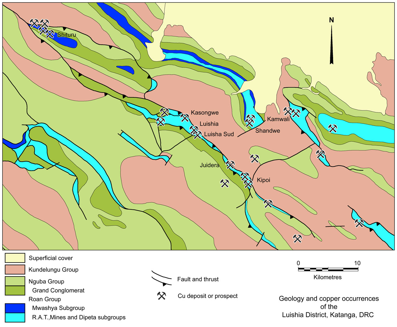
The Kipoi group of sediment hosted copper deposits/occurrences, which include the Kipoi North, Kipoi Central, Kileba, Kaminafitwe and Judeira deposits, are located ~12 km SE of the Luishia deposit, ~60 km NW of Lubumbashi and ~200 km ESE of Kolwezi in Katanga Province of the Democratic Republic of Congo (#Location: Kipoi Central - 11° 15' 7"S, 27° 5' 43"E; Judeira - 11° 13' 25"S, 27° 3' 49"E;).
Small scale and sporadic artisanal mining has taken place in the Kipoi area prior to and after the first modern exploration, which began with pitting by the State owned Gecamines during the 1980�s as part of a regional campaign. Limited work carried out by Geacamines and partners in the area during the late 1990's and early 2000's was restricted to pitting, trenching and the development of a number of exploratory adits at the Kipoi Central and Kileba prospects. Exploration trenches had also been excavated by Gecamines at Kipoi Central, Kipoi North, Judeira, Kileba and Kaminafitwe.
No historical mineral resource or reserve estimates had been calculated for the Kipoi deposits. Despite work completed
prior to 2008 providing strong support for the presence of copper, results were regarded as insufficient to meet the rigour necessary for a recognised independent Mineral Resource estimation.
Exploration by Tiger Resources, including a drilling program, was commenced in 2006. Mining commenced at Kipoi Central on a Stage 1 starter pit, extracting high-grade oxide copper mineralisation and processing it through a heavy media separation (HMS) plant. After completion of this initial HMS stage, production of copper cathode at a Solvent Extraction Electrowinning (SXEW) plant began in May 2014. The mine is operated by Société d'Exploitation de Kipoi SPRL (SEK), which is currently (2016) 100% owned by Tiger Resources Limited.
Geological Setting
The Kipoi deposits are located in the central Congolese section of the Central African Copperbelt, between the Luishia and Luiswishi deposits, 12 km to the NW and 50 km to the SE respectively. The deposits of the Central African Copperbelt, in both Zambia and the DRC, are hosted within the Neoproterozoic Katanga Supergroup of the Pan-African orogenic belt, the Lufilian Arc. In the DRC, this structural arc is characterised by linear outcrops of Roan Group sedimentary rocks, occurring as megabreccias in the cores of a series of tight, disjointed, sheared anticlines. This mega-breccia contains mega-fragments (écailles) of Roan Group rocks up to 10 km in length, which host most of the major copper deposits.
In the DRC, the Katanga Supergroup is composed of:
Roan Group
• R.A.T. Subgroup - >200 m of purple/lilac coloured dolomitic and chloritic brecciated siltstone and dolostone, interpreted to represent the insoluble residue of a much thicker evaporite package that has undergone dissolution.
• Mines Subgroup - an up to 350 m thick transgressive sequence of interbedded, finely bedded to massive dolostones and dolomitic sedimentary rocks, the lower sections of which are variably silicified and dolomitised, and carbonaceous.
• Dipeta Subgroup - comprising an initial regression (RGS and Mofya Formations) and overlying transgression (Kansuki Formation), resulting in an ~600 m thick succession similar to the R.A.T. and Mines subgroups. The upper Dipeta Kansuki Formation, has previously been allocated to the lower Mwashya Subgroup. At Likasi, 45 km NW of Kipoi, the Kansuki Formation contains two mafic volcaniclastic units, the "Roches de Kipoi", RK1 and RK2, separated by a band of dolomitic rocks, which is locally marked by massive hematite at the top (Cailteux et al., 2007). These volcanic rocks are part of a narrow arcuate band that follows the inner Lufilian Arc from the Angolan to Zambian borders to the west and SE respectively.
• Mwashya Subgroup - a 200 to 250 m thick sequence comprising a lower unit, the Kamoya Formation, of irregularly bedded dolomitic shales to siltstones, overlain by the Kafubu Formation, a sequence of finely bedded, grey to dark grey or black, pyritic carbonaceous shales, capped by the thinner Kanzadi Formation composed of pink to green feldspathic sandstones with variable amounts of shale or siltite. At Likasi, the lowermost of these units, the Kamoya Formation, includes clastic and mafic pyroclastic rocks of "Roches de Kipoi" RK3.
Nguba Group, that is up to more than 2000 m thick, commencing with the <30 to >1200 m thick, Sturtian 740 Ma Grand Conglomérat (Mwale Formation) diamictite unit, overlain by shales and the calcareous sedimentary rocks and dolostones of the Kakontwe Formation and an up to 1000 m thick suite of dolomitic sandstones and siltstones.
Kundelungu Group, commencing with the 40 to 60 m thick diamictites of the ~630 Ma Marinoan Petit Conglomérat (Kyandamu Formation), overlain by up to 3000 m of dolomitic sandstones, siltstones and argillites.
For details of the regional setting, stratigraphy and metallogeny of the Central African Copperbelt and the Kipoi deposits, see the separate Central African Copperbelt - Congolese/Katangan Copperbelt record.
The geology of the main deposits can be sumarised as follows:
Kipoi Central
The host lithological succession at the Kipoi Central deposit has been mapped as part of the Mwashya Subgroup by Gecamines, and occurs as a >900 x ~600 m, NE-SW oriented écaille embedded within both talcose brecciated rocks of the R.A.T. Subgroup and tectonic breccias (collectively referred to as the 'Breche Heterogene'). Both sequences are overlain, or structurally abutted, by diamictites of the Nguba Group across a structurally overprinted or reactivated unconformable contact.
In the immediate deposit area, the Mwashya Subgroup host succession comprises a uniformly steep (60 to 70°) SSE dipping to upright, package of NNE (~35°) striking, interbedded carbonate rocks and siltstones. Bands of these interbedded lithologies that are 100 to 200 m thick are separated by a rock unit that primarily consists of light green talc-chlorite-carbonate minerals, interpreted to represent a retrograde altered protolith of mafic or intermediate to mafic volcanic or pyroclastic rocks. These volcanic and sedimentary packages may represent structural repetitions, as discussed below,
In drillcore, the volcanic/pyroclastic rocks are massive, with internal breccias of irregular, angular monomictic, clasts. In outcrop, they commonly form a recessed topography and where they have no preserved internal structure, but have a distinct massive texture and a talcous feel. A narrow, 1 to 3 m wide, jasperoid haematite unit commonly locally marks the hanging wall contact with the adjacent rock unit. To the SE, the volcanic rocks are in contact with fine and medium thick bedded and slaty calcareous siltstones with minor stromatolitic carbonate beds.
Above the base of oxidation, the carbonate rocks of the sequence are red-brown, strongly weathered, partly indurated by iron oxides and silica, and have recognisable original cryptalgal lamination textures. These oxidised carbonate rocks tend to contain enriched supergene copper and cobalt mineralisation.
This coherent succession is irregularly truncated in the footwall, and transgressively up through the sequence, by talcous heterogenous breccias of the 'Breche Heterogene', which comprises a soft, talc-calcareous matrix enclosing subangular, partly rounded clasts of grey and purple calcareous siltstones. This breccia has a very irregular contact with the juxtaposed rocks and has no known base.
In the deposit area, the unconfomably overlying diamictites of the Nguba Group are composed of a massive competent siltstone to sandstone facies that includes well rounded matrix supported clasts of quartz, quartzite and low grade metamorphic schist.
Structural analyses indicate that parasitic folding and faulting of the sequence in the deposit area occurred during brittle faulting of the Mwashya Subgroup package of rocks. Outcrop relationships suggest the unconformable contact relationship with the overlying Nguba Group has been structurally overprinted and reactivated, and the contact with the 'Breche Heterogene' is an irregular but generally steep to upright surface.
Late stage mineralised veins cross cut the contact between the Nguba and Mwashya Subgroup rock sequence.
In the deposit area, the host strata are deformed by a swarm of NE-SW oriented post-lithification brittle reverse faults which transect the Mwashya Subgroup rocks and dip to the SE, and led to the formation of broad zones of brittle deformation and brecciation. The displacement across these observed faults cannot be measured, although the juxtaposition of the strata suggests that is more likely in the order of tens, rather than hundreds of metres. It is also unclear if these faults extend into the 'Breche Heterogene'.
Zammit et al. of Cube Consulting (2013) infer that the hosts to the Kipoi Central deposit area is a tilted segment of a structurally and halokinetic dismembered écaille of Mwashya Subgroup sedimentary rocks which terminate in the east against 'Breche Heterogene' and abut to the west, an uplifted segment of Lower Mwashya Subgroup pyroclastic rocks across an inferred NW-SE fault zone. Similarly, below the ore deposit, the host sedimentary rocks are thrust over the pyroclastic sequence. This deformation apparently occurred during or after the deposition of the Nguba Group diamictites and postdated lithification of both stratigraphic units.
From the information sighted, it is unclear as to whether the mafic pyroclastic units and iron formation that underlie the host rocks belong the basal Kamoya Formation of the Mwashya Subgroup, or are part of the Dipeta Subgroup Kansuki Formation. If the latter, the host may be either lower Mwashya Subgroup, or upper Dipeta Subgroup.
Mineralisation
The bulk of the mineralisation at Kipoi Central is hosted by brittle and brittle-ductile structures in dolomitic
siltstones and dolostones of the upper Mwashya Subgroup, with minor mineralisation occurring in the pyroclastic rocks and the overlying diamictites. Structure appears to be the predominant control on the distribution and emplacement of mineralisation.
In fresh drill core, mineralisation is observed to occur as both cross cutting and bedding parallel veins but is also present in the matrix of crackle, mosaic and rubble breccias of tectonic origin. Structure and rock fabric resulting from deformation provide the main setting for mineralisation, although algal laminated carbonate rocks and graphitic calcareous siltstone represent an addition control particularly for stratabound mineralisation.
The stratabound mineralisation/veining appears to occupy sedimentary porosity and is apparently deformed by subsequent sediment compaction during lithification. Textures related to soft-sediment deformation suggest a phase of syn-diagenetic mineralisation.
Copper bearing veins in the primary zone contain chalcopyrite and pyrite with a quartz-calcite as gangue, and are compositionally slightly different from the bedding-parallel veins, which are exclusively composed of chalcopyrite.
Deep weathering, oxidation and remobilisation of copper has substantially modified the ore assemblage. The dominant copper bearing mineral in the oxide zone is malachite, with minor azurite pseudomalachite, chalcocite, bornite, native copper and chalcopyrite. Oxide mineralisation is partly the result of in situ replacement of primary sulphides, but also occurs as coatings on bedding, cleavage and joint surfaces, and as minor cavity infill mineralisation. As a result, mineralisation is dispersed over a much larger volume of rock than in the primary sulphides.
Mineralisation within the deposit is repeatedly localised and enhanced near faults throughout the Mwashya Subgroup, with strong enrichment in the fault matrix, giving way laterally to mosaic and simple veining.
Significant cobalt mineralisation appears to be localised near the footwall contact of the Upper Mwashya Subgroup sedimentary rocks and the underlying pyroclastic rock. It occurs as a soft, black, talc-rich mass that ranges up to several tens of metres in width. The cobalt bearing mineral is fine and has not been observed, but is assumed to be heterogenite.
Mineralisation is generally absent in the 'Breche Heterogene', although the contact zone with the Mwashya Subgroup sedimentary rocks tends to well mineralised.
Localized copper-oxide bearing clasts set in a barren sandy matrix are found within the overlying Nguba Group diamictites, suggesting that primary mineralisation, oxidation and erosion predates the deposition of the latter.
Copper-bearing veins occur in brittle fractures that cross cut the Mwashya Subgroup-Nguba Group contact implying a prolonged deformation and mineralising event.
Rock competency and rheological contrast are interpreted to be important, with the response of different rock types to deformation determining the generation and localisation of porosity in the form of veins and breccias. This may be reflected in the concentration of structures in the more brittle clastic rocks in contrast to the more ductile pyroclastics.
Kipoi North
Although only ~1 km north of Kipoi Central, the geology at Kipoi North differs significantly from other deposits in the district. Based on outcrop and trenching during the 1980's, Gecamines mapped Lower Mines Subgroup rocks hosting mineralisaiton in the area. Subsequent to the mapping, artisanal miners exploited these cuperiferous beds and established a small east-west oriented open pit, sub-parallel to the strike of the geologic units. The entire exposed section in the workings represents a 1.2 km long, overturned, 65° north dipping limb of a tight, near isoclinal, south thrusted recumbent fold of Lower Mines Subgroup rocks, surrounded by 'Breche Heterogene'.
The lower Mines Subgroup sequence, from the stratigraphic base, and from north to south is:
• R.A.T. (Roches Argilleuses Talceuse) Grises - massive grey-green to red oxidised calcareous siltstones of unknown thickness, although <5 m is preserved above a structural contact with the underlying R.A.T. Subgroup;
• D.Strat. (Dolomies Stratified) - 4 to 8 m of grey, stratified, fine-grained, argillaceous and chloritic, dolostone in fault contact with the stratigraphically underlying R.A.T. Grises across a sheared rubble breccia zone up to several metres thick;
• R.S.F.(Roches Siliceuses Feuilletées) - <3 m of finely laminated silty and silicified stromatolitic dolostone with slaty interbeds;
• R.S.C. (Roches Siliceuses Cellulaires) - vuggy, cellular, massive, stromatolitic, silty and silicified dolostone that is generally <20 m, but may be up to 40 m thick;
• S.D. (Schistes Dolomitiques) - a thin (< 1m) graphitic, laminated, sulphidic dolomitic siltstone which immediately overlies the R.S.C., overlain by a thick light red, laminar stromatolitic dolostone succession.
The 'Breche Heterogene' occurs in several locations, flanking and underlying the Mines Subgroup sequence, and has been intersected in drill holes as intermittent dyke-like bodies several metres thick. All of these contacts are usually irregular
and discordant. Texturally, it is compose of a polymictic breccia of oxidised red, grading upwards into reduced grey-green facies calcareous siltstone fragments floating in a soft talcose, calcareous clay rich matrix.
Mineralisation
The mineralisation at Kipoi North, is predominantly secondary, stratabound and concentrated in the D.Strat., R.S.F., and R.S.C. units of the Mines Subgroup. Within the D.Strat., malachite occurs parallel to the thin laminated, silty dolostone layers, whereas in the R.S.F., mineralisation is pervasively distributed within the slaty layers of the rock. In the R.S.C. it is associated with the vughs, veins and fractures that occur from the immediately contact with the R.S.F., up to several tens of metres into the unit. The mineralisation in these units corresponds to the 'Lower Orebody' found throughout the Congolese Copperbelt (Cailteux et al., 2005). The wide occurrence of mineralisation at Kipoi North is attributed
to the supergene re-distribution of mineralisation during weathering and oxidation.
Kileba
The Kileba deposit is located ~7 km SE of Kipoi Central. Artisanal workings intermittently follow the crest of a NW trending ridge which extends over a distance of about 1.1 km, offset across a NE trending gully into north western and a south eastern ridge segments
The host rocks at Kileba have been attributed to the Mwashya Subgroup, overlain by diamictites of the Nguba Group Grand Conglomérat.
Northwest striking weathered talcose pyroclastic rocks, which occur on the northeastern side of the mineralised ridge, are interpreted to be the oldest rocks of the Mwashya Subgroup in the deposit area. They are directly overlain across a strongly sheared, brecciated and mineralised zone, interpreted to be a reverse fault, by a sequence of siliciclastic sedimentary rocks, which comprise interbedded dolomitic, graphitic and shaly siltstones, a massive algal dolostone member, an evaporitic calcarenite member and interbedded fine and medium grained sandstone units. In detail this clastic sequence comprises, from the base:
• Dolomitic siltstone - 10 to 15 m of increasingly silty laminated dolostone and calcareous siltstone with strong stratabound sulphide near the base with chalcopyrite and pyrite;
• Carbonaceous siltstone - 6 to 10 m of thin bedded graphitic siltstone with carbonaceous beds;
• Dolostone and calcarenite - a 36 to 65 m interval comprising a highly talcose, soft, soapy rock, which when fresh is a crenulated, calcareous, thinly bedded cryptalgal calcarenite. Towards the centre it encloses an alga biohermal subfacies with strongly developed stromatolitic columns and mats;
• Dolomitic siltstone - >40 m of red siltstone, partly silicified with interbeds of algal stromatolites and thinly bedded dolostones and two closely spaced and laterally continuous, about 1 to 2 m thick haematite marker beds which are ~120 m stratigraphically above the pyroclastic contact. Locally these hematite markers contain internal breccias, but are generally composed of laminated specular haematite.
The sequence at Kileba is, overall, sub-vertical to steeply SW dipping, becoming shallower to the NW, with a dip reversal on the northwestern end of the southeastern ridge segment, where the rocks abruptly change dip to the NE, interpreted to be associated with a narrow discrete NNE trending sub-vertical cross fault. A second dip reversal is inferred in the gap separating the two ridge segments as the north western outcrop of the ridge dips to the SW. Sub-vertical, north trending brittle faults are mapped at the north end of the northwestern outcrop area. NNE trending structures cross-cut and post-date NW trending structures, suggesting either a regional stress variation with time, or progressive deformation resulting in secondary splays developing locally.
Regional magnetic data suggest that the Kileba area is located on the northeastern flank of a regional NW-striking syncline, the axis of which is located to the SW of Kileba. The syncline may be either followed by an anticline, or truncated against a fault to the SW. To the NW, this syncline appears to have been thrust over another syncline.
Mineralisation
The NW striking and SW dipping sequences on the NW and SE ridge segments at Kileba are referred to as the Kileba North and the Kileba South deposits respectively. The two deposits exhibit differing grade tenors, although both are considered to have originally been parts of a single, continuous, deeply rooted zone of deformation and mineralisation that has subsequently been fault dislocated.
Kileba South is a structurally controlled copper orebody, dipping steeply to the SW over a strike length
of 730 m. It includes a broad zone of supergene copper enrichment in the hangingwall of a mineralised shear zone, where brittle deformed rocks adjacent to a reverse fault have created a favourable setting for both primary and supergene enrichment. The fault hosted primary mineralisation occurs as a cross cutting quartz-carbonate-chalcopyrite vein network in the hanging wall of the fault and in the matrix of a brittle, rubble-breccia with a distinct fault gouge in the footwall. The brittle vein mineralisation overprints stratabound, in places, massive sulphide (pyrite and chalcopyrite) mineralisation, which occurs at several stratigraphic level and is commonly associated with graphitic and dolomitic shales, and silicified, algal stromatolitic beds.
Above the base of oxidation, weathering of sulphides caused lateral dispersion of secondary copper minerals, generating a 700 x 130 m supergene blanket that extends to a depth of 120 m and accounts for the bulk of the reported mineral resource.
Kileba North dips steeply to the SW over a strike length of 650 m, and is interpreted to be a continuation of the structurally controlled Kileba South copper mineralisation. Mineralisation has been indicated to a vertical depth of at least 110 m within the oxide zone, and in 2013 was open at depth and along strike to the NW.
Judeira
The Judeira deposit is located ~4.5 km NW of Kipoi Central, and lies along a regional NW trending topographic ridge along which Kipoi Central and Kileba are also situated. At Judeira, this ridge occurs as a NW and SE segment, separated by an ~800 m wide, low lying area of limited exposure.
Gecamines mapped the sequence along the mineralised ridge at Judeira as undifferentiated Mines and Dipeta subgroups, underlying Mwashya Subgroup rocks. The deposit is apparently located on the SW dipping limb of a NW trending sheared anticlinal structure.
At Judeira, the host package of rocks strike NW at 320°, dip at 35 to 55°SW, and is dominated by a succession of pyroclastic rocks in contact with clastic sedimentary and carbonate rocks. Dip angles are highly variable, complicated by northeast striking sub-vertical faults. From footwall to hanging wall, the stratigraphic package, which is >200 m thick, comprises:
Roan Group undifferentiated,, representing either a Mines of Dipeta subgroup sequence, most likely the latter.
• Talcose dolomites - massive to stratified, red, talcose, dolomitic, sandy siltstones;
• Silicified dolostones and silty carbonaceous shales - which comprise slaty, finely laminated siltstones, interbedded with more massive, nodular, calcareous dolomitic siltstone;
• Banded iron formations - found within the pyroclastic package (see below), at and near the contact with siliciclastic sedimentary rocks, occurring as several apparently discontinuous and possibly en echelon hematite beds, ranging from <1 up to 10 m in thickness. The coincidence of mapped hematite lodes and a strong magnetic signature in the airborne geophysical data suggests the lodes contain magnetite at depth;
• Pyroclastic volcanic rocks - which appear to be in conformable contact with siliciclastic package, and medium-grained, with a light-green colour in outcrop, where they are generally 'soft' with a soapy feel, and no internal structure. They are dominated by chlorite, serpentinite and talc, which are considered retrograde alteration products;
• Upper Roan Group shales, probably of the upper Mwashya Subgroup.
Nguba Group arenites.
Mineralisation
The main copper mineralisation appears to be hosted within fractured, finely laminated, vuggy, possibly algal, stromatolitic silty carbonates over a ~20 to 30 m stratigraphic interval. This mineralisation is found in direct hanging wall contact with the pyroclastic rocks, forming a distinct structural-tratigraphic target. In the footwall, the mineralisation appears to terminate against a band of highly talcose rock, exposed in artisanal workings as white and red-white, and in places black, soft, soapy, talcose material that has a strong ductile strain fabric, most likely a shear zone. The talcose material contains fragments of siltstone and sandstone with rubble breccias along lithological contacts with the adjacent rocks. The talcose material is exploited by artisanal miners for its cobalt content, respresenting a second mineralised zone.
The copper mineralisation at Judeira is principally supergene malachite, derived from a primary source, yet to be identified.
Northeast trending structures appear to be terminating or offsetting structures.
Kaminafitwe
Kaminafitwe is located ~3.5 km NE of Kipoi Central, and is defined by artisanal workings, covering an area of ~200 x 80 m at the base of a NE trending ridge.
Mineralisation occurs within an asymmetric, east to NE trending anticline structure cored by interbedded stratified siltstones and calcareous siltstones correlated with the Roan Group, most likely of the Dipeta and/or Mwashya subgroups. The northern limb of the fold is in contact with highly weathered silty shale intruded by a swarm of 1 to 4 m thick, steeply dipping mafic dykes. Narrow (<1 m wide at surface) ferruginous haloes flank the weathered mafic dykes. The dykes with ferruginous halos extend over a width of up to 40 m, which persist along strike for several hundred metres. In the SW, the sedimentary rocks appear to be truncated by an east dipping fault breccia with a sliver of carbonaceous siltstones in the immediate hanging wall. This fault separates the sedimentary rocks from talcose ferruginous weathered pyroclastic rocks. The fault breccia zone is several metres thick and contains supergene copper minerals. According to Gecamines mapping, the fault zone broadly aligns with a narrow corridor of Roan Group sedimentary rocks flanked by Nguba Group diamictites to the NW and SE. This strucure is orthogonal to the main structural trend of the region.
Mineralisation
At Kaminafitwe, supergene oxide copper and cobalt mineralisation is located in the ferruginous hematitic contact aureoles surrounding the individual mafic dykes of the swarm as described above.
Mineral Resources
Published mineral resources at April 2012 at a 0.5% Cu cut-off were (Zammit et al., 2013):
Kipoi Central
Measured + indicated resource
Oxide ore - 12.9 Mt @ 1.8% Cu, 0.1% Co;
Transitional ore - 5.4 Mt @ 1.9% Cu, 0.1% Co;
Sulphide ore - 5.5 Mt @ 2.8% Cu, 0.1% Co;
TOTAL - 23.8 Mt @ 2.0% Cu, 0.1% Co.
Inferred resource
Oxide ore - 4.2 Mt @ 1.0% Cu, 0.1% Co;
Transitional ore - 1.1 Mt @ 1.0% Cu, 0.1% Co;
Sulphide ore - 2.6 Mt @ 1.1% Cu, 0.1% Co;
TOTAL - 7.9 Mt @ 1.0% Cu, 0.1% Co;
Kileba
Indicated resource
Oxide ore - 6.0 Mt @ 1.46% Cu, 0.06% Co;
Transitional ore - 2.1 Mt @ 1.60% Cu, 0.05 Co;
Sulphide ore - 0.5 Mt @ 1.43% Cu, 0.04% Co;
TOTAL - 8.6 Mt @ 1.49% Cu, 0.05% Co.
Inferred resource
Oxide ore - 0.7 Mt @ 0.81% Cu, 0.04% Co;
Transitional ore - 0.5 Mt @ 0.78% Cu,0.04% Co;
Sulphide ore - 1.0 Mt @ 1.75% Cu, 0.04% Co;
TOTAL - 2.2 Mt @ 1.23% Cu, 0.04% Co;
Kipoi North
Indicated resource
Oxide ore - 3.4 Mt @ 1.36% Cu, 0.05% Co;
Transitional ore - 0.5 Mt @ 1.21% Cu, 0.03 Co;
Sulphide ore - 0.1 Mt @ 1.05% Cu, 0.04% Co;
TOTAL - 4.0 Mt @ 1.33% Cu, 0.05% Co.
Inferred resource
Oxide ore - 0.4 Mt @ 1.20% Cu, 0.04% Co;
Transitional ore - 0.4 Mt @ 1.06% Cu,0.03% Co;
Sulphide ore - 0.3 Mt @ 1.05% Cu, 0.043% Co;
TOTAL - 1.1 Mt @ 1.10% Cu, 0.03% Co;
Mineral resources at 31 December, 2013 (Tiger Resources website, 2016; 0.3% Cu cut-off at Kipoi Central, 0.5% for the rest), were:
Measured resource
Kipoi Central - 8.0 Mt @ 2.8% Cu, 0.12% Co;
Indicated resource
Kipoi Central - 40.4 Mt @ 1.1% Cu, 0.06% Co;
Kileba - 8.6 Mt @ 1.5% Cu, 0.05% Co;
Kipoi North - 4.0 Mt @ 1.3% Cu, 0.05% Co;
TOTAL Measured + Indicated resource - 61.0 Mt @ 1.4% Cu, 0.07% Co.
Inferred resource
Kipoi Central - 2.9 Mt @ 0.08% Cu, 0.07% Co;
Kileba - 2.2 Mt @ 1.2% Cu, 0.04% Co;
Kipoi North - 1.1 Mt @ 1.1% Cu, 0.03% Co;
Judeira - 6.1 Mt @ 1.2% Cu, 0.03% Co;
TOTAL Inferred resource - 12.3 Mt @ 1.1% Cu, 0.04% Co.
TOTAL mineral resource - 73.3 Mt @ 1.3% Cu, 0.06% Co.
Geological plans and sections yet to be drawn and inserted - to be completed soon
The information in this summary is drawn from:
"Reidy, P., Dorling, S., Adams, P., Adams, R, and de Klerk, Q., 2009 - Kipoi Copper Project, in the Democratic Republic Of the Congo; an NI43-101 Technical Report, prepared for Tiger Resources Ltd., by CSA Global Pty Ltd; 214p."
"Black, C., Zammit. M., Dorling, S. and Readett, S., 2011 - Kipoi Copper Project, Democratic Republic Of Congo, Stage 2 preliminary economic assessment; an independent NI43-101 Technical Report, prepared for Tiger Resources Ltd., by Cube Consulting Pty Ltd., 250p."
"Zammit. M., de Klerk, Q., Dorling, S. and Readett, S., 2013 - Kipoi Copper Project, Democratic Republic Of Congo, Stage 2 definitive feasibility study; an independent NI43-101 Technical Report, prepared for Tiger Resources Ltd., by Cube Consulting Pty Ltd., 257p."
The most recent source geological information used to prepare this decription was dated: 2013.
This description is a summary from published sources, the chief of which are listed below.
© Copyright Porter GeoConsultancy Pty Ltd. Unauthorised copying, reproduction, storage or dissemination prohibited.
Kipoi Central Judeira
|
|
|
Porter GeoConsultancy Pty Ltd (PorterGeo) provides access to this database at no charge. It is largely based on scientific papers and reports in the public domain, and was current when the sources consulted were published. While PorterGeo endeavour to ensure the information was accurate at the time of compilation and subsequent updating, PorterGeo, its employees and servants: i). do not warrant, or make any representation regarding the use, or results of the use of the information contained herein as to its correctness, accuracy, currency, or otherwise; and ii). expressly disclaim all liability or responsibility to any person using the information or conclusions contained herein.
|
Top | Search Again | PGC Home | Terms & Conditions
|
|


