|
Broken Hill |
|
|
New South Wales, NSW, Australia |
| Main commodities:
Zn Pb Ag
|
|
 |
|
|
 |
Super Porphyry Cu and Au


|
IOCG Deposits - 70 papers
|
All available as eBOOKS
Remaining HARD COPIES on
sale. No hard copy book more than AUD $44.00 (incl. GST) |
|
|
The Broken Hill zinc - lead - silver orebodies are located 40 km east of the South Australian border in far western New South Wales, approximately 950 km WNW of Sydney and 450 km north-east of Adelaide (#Location: 31° 57' 50"S, 141° 28' 03"E).
Regional Setting
The Broken Hill deposits lie within the Willyama Block or Broken Hill Domain, which extends from far western New South Wales into eastern South Australia. This block is the southeastern segment of the 200 x 400 km Curnamona Province, and is composed of Palaeo- to Mesoproterozoic metamorphic rocks and minor intrusives. The Willyama block is overlain by Neoproterozoic sedimentary cover which separates it from the similar rocks of the Euriowie Block to the east, while the equivalent Olary Block to the west in South Australia is separated from the Willyama Block by younger cover.
The Neoproterozoic Adelaide Rift Basin (related to extension preceding the late Neoproterozoic Rodinia break-up) separates the Curnamona Province from the Gawler Craton to the west, and masks the mid- to late-Palaeoproterozoic suture between the Gawler craton and Curnamona province. The northeastern, eastern and southeastern margins of the preserved Curnamona province are determined by the Tasman Line, which marks the Rodinia break-up and separation of the eastern sections of the pre-breakup cratonic mass. Prior to the break-up of Rodinia, the Gawler Craton, Curnamona Provinces, and cratonic elements in North America and Antarctica were all part of the larger Mawson craton.
The Willyama Block is largely occupied by the metamorphic rocks of the 7 to 9 km thick Willyama Supergroup, which comprises amphibolite to granulite facies schists and gneisses, ranging from andalusite-muscovite, through sillimanite-muscovite, sillimanite-potassium feldspar-garnet to hornblende-granulites, with lesser amphibolite and basic granulite. It has been interpreted to represent metamorphosed protoliths of clayey and sandy sediments with intercalated basic and felsic volcanics and minor sub-volcanic intrusives. Basement rocks to the Willyama Supergroup are not exposed, but inheritance indicates the presence of Archaean and older Palaeoproterozoic crystalline crust..
The Willyama Supergroup is interpreted to have been deposited in the epi-continental Curnamona rift basin between 1720 and 1640 Ma, and was accompanied by bimodal magmatism. The Olary Domain, exposed to the west in South Australia, represents the palaeo-basin flank to this rift basin, further from the rift axis (Conor and Preiss 2008). The Willyama Supergroup has been interpreted to represent three stages of progressive up-sequence deepening in the central part of the rift basin, comprising:
• Early syn-rift deposition, from ~1720 to ~1690 Ma, within a fluviatile to shallow marine shelf sequence in a restricted saline, oxidised basin, grading to a marine succession. The oldest rocks in the Curnamona Province are the ~1720 to 1710 Ma Curnamona Group which is only exposed in South Australia. This succession commenced with the Wiperaminga Subgroup which includes variably magnetite-rich, micaceous, siliceous and albitic metasedimentary rocks, including interbedded migmatitic gneiss and local metaconglomerate. These are followed by the Ethiudna subgroup mostly psammitic rocks with some calc-silicate minerals, including basal basalt and quartzite, further albitic metasedimentary and quartzo-feldspathic to pelitic rocks, and A-type meta-volcanic/granitic units which intrude and are intercalated with the Curnamona Group, along with mafic intrusive rocks (Conor and Preiss, 2008). This sequence was succeeded by metamorphic rocks of the Thorndale Composite Gneiss (and laterally overlapping Rantyga Group) and the Thackaringa Group, interpreted to have been formed from protoliths that were relatively sandy shallow marine sedimentary rocks, with a possible evaporitic, or hypersaline component represented by albitic horizons (Stevens et al., 1988; Fitzherbert and Downes, 2015).
• Rift deepening and magmatic escalation, between ~1690 and ~1670 Ma, which commenced with the Broken Hill Group, that conformably and gradationally overlies the Thackaringa Group and includes the Allendale Metasediments and Purnamoota Subgroup. This group grades from a pelite-dominant base to interbedded pelite and psammite at its top. The succeeding Sundown Group contains identical lithologies to that of the upper part of the Broken Hill Group, comprising interbedded pelitic, psammopelitic and psammitic metasedimentary rocks, except that it lacks any syn-depositional igneous units. The siliciclastic sedimentary protoliths to both groups has been interpreted as a deep water turbidite sequence (e.g., Wall, Etheridge and Hobbs 1976; Plimer 1986; Laing 1980; Willis et al., 1983), although others (Stevens et al., 1988), suggesting a slightly shallower water shelf setting with minor intervening storm beds. The 'Potosi-type' Parnell and Hores gneisses are interpreted to be coherent volcanic and volcaniclastic mass flow deposits (Stevens et al. 1988), deposited during transgressive phases of sedimentation (Dyson 2003) and active normal faulting (Conor and Preiss 2008). The abundant basic gneisses of the Annandale and Silver King Metadolerites of the Lady Louise Suite, probably formed as syndepositional, high-Fe tholeiitic dykes and sills.
Deposition resumed in the lateral Olary Domain after a 20 m.y. hiatus, commencing with the Saltbush Group, which disconformably overlies the Ethiudna Subgroup, commencing with a regional calc-silicate that is correlated with a similar calc-silicate at the base of the Broken Hill Group. This unit is followed by graphitic metasiltstone, a psammite-dominated suite, overlain by the pelitic rocks containing manganiferous banded quartz-magnetite-grunerite-garnet iron formation and quartz-garnetite rocks similar to the main Broken Hill Group section (Conor and Preiss 2008). Tholeiitic amphibolite sills of the Lady Louise Suite intrude this succession to the top of the upper psammites.
• Post-rift sequences, from ~1670 to ~1640 Ma, representing deeper water, sag phase deposition post-dating the climax of rifting, with the stratigraphic progression reflecting an up-sequence change from deeper shelf/plateau sedimentation to shallow water deposits, partly with shoreface characteristics (Dyson 2003). It is represented by the Cartwrights Creek, Bijerkerno and Dalnit Bore metasediments of the Paragon Group, and comprises thinly bedded graphitic, pelitic to psammopelitic phyllite, with lesser fine-grained graphitic, felspathic psammite, with calc-silicate and albitic interbeds.
The Strathearn Group is the stratigraphic equivalent of the Paragon Group in the Olary Domain, where a similar sequence of interlayered graphitic and aluminous pelite is reflected by the Alconie Formation, which grades into albitic, psammitic rocks of the overlying Mooleulooloo Formation and pelitic schist of the uppermost Dayana Formation.
These sequences were subjected to deformation by the early Mesoproterozoic 1600 to 1580 Ma Olarian Orogeny. The only Mesoproterozoic rocks in the Broken Hill Domain belong to the syn- to post orogenic granites (1595 to 1580 Ma) of the Mundi Mundi Suite. However, to the west in South Australia, extensive suites of volcanosedimentary, volcanic and granitic rocks are mapped, e.g., the 1595–1580 Ma Radium Creek Group in the Mount Painter and Mount Babbage Inliers; the 1585 to 1575 Ma Ninnerie Supersuite granites with synchronous silicic volcanism and the extensive rhyolitic to dacitic A-type Benagerie Volcanic Suite, as well as sequences of shallow water to deltaic quartzite, schist, gneiss, phyllite and calc-silicate (Fitzherbert and Downes, 2015).
Subsequent deposition was during the Neoproterozoic, related to rifting that produced the Adelaide Rift Complex, and eventually led to the breakup of Rodinia. It developed over the deformed Palaeoproterozoic basement, representing continental rift to passive continental margin deposition. In the Broken
Domain sedimentation took place in two stages, the Poolamacca Group, between ~850 and 810 Ma, which was related to NE–SW extension, with the deposition of fluviatile to shallow marine, mature sandstone and lesser conglomerate, followed by stromatolitic limestone and eruption of the 827±9 Ma Wilangee Basalt, interpreted to be a continental flood basalt. These were followed by a depositional hiatus occurring between ~810 and ~700 Ma in the Broken Hill Domain, attributed to Sturtian tectonism, uplift and extensive erosion of the Poolamacca Group. However, in South Australia, to the west, sedimentation continued, with the deposition of the fluviatile to shallow marine sequences of the Burra Group. Sedimentation resumed in the broken Hill Domain in the mid Cryogenian withthe deposition of the Torrowangee Group, which persisted until ~630 Ma. This unit represents a syn-rift depositional environment and includes the two globally distributed glacial successions, the Sturtian from ~700 to 660 Ma, and Marinoan from ~645 to 630 Ma, separated by carbonate-rich interglacial deposition (Fitzherbert and Downes, 2015).
The Torrowangee Group was unconformably overlain by the late Neoproterozoic ~630 to 580 Ma Farnell Group which marked the end of a period of basement instability and the initiation of sedimentation on a stable shelf environment. The sequence represents marine transgression, with upward-coarsening sequences reflecting subsequent marine regression, and comprises a basal cap dolomite, through a thick siltstone-rich package, into an upward-coarsening sequence of quartzite and sandstone. This succession was followed by a prolonged depositional hiatus punctuated by the intrusion of a northwest-trending dyke swarm to the west of Broken Hill at ~580 Ma, succeeded by deposition of shallow marine sediments of the ~540 to ~515 Ma Arrowie Basin which were unconformably deposited on the Palaeoproterozoic basement.
Inversion of the Neoproterozoic-Cambrian passive margin is thought to have occurred on the eastern Gondwana margin during the 515 to 500 Ma Delamerian Orogeny (Foster et al., 2005). During this deformational event (D4), the Neoproterozoic sequences at Broken Hill underwent low-grade metamorphism (lower greenschist facies) with large-scale, relatively open folding along a north-south or NW-SE axis.
Regional Deformation and Metamorphism
Inversion of the Curnamona Rift Basin took place during the 1620 to 1580 Ma, Olarian Orogeny, although heating and partial melting of the Curnamona Province is evident prior to any pervasive deformation. Textural evidence indicates widespread aluminosilicate-cordierite crystallisation and partial melting took place across the Broken Hill and Olary domains under low strain and possible low pressure conditions (Stevens 2006). Monazite dating (e.g., Forbes et al., 2008; MacFarlane and Frost, 2009) indicate a thermal event between 1630 and 1620 Ma, which may reflect early heating..
The compressional Olarian orogenesis comprised northward-directed crustal shortening, followed by continued shortening and the development of approximately north-south oriented folds (Wilson and Powell 2001; Betts and Giles 2006).
Two periods of deformation, accompanied the prograde metamorphism in the Broken Hill and Euriowie Blocks, namely D1 which produced large recumbent to shallowly inclined folds and a layer parallel S1 foliation (Laing et al., 1978; Marjoribanks et al., 1980; Hobbs et al., 1984) with a NW vergence, and the development of a high-T, low-P, metamorphic field array, sub-parallel to the regional stratigraphy (Binns 1964; Phillips 1978; Webb and Crooks 2006). This event produced a metamorphic gradient that progressed from granulite facies at the lowest stratigraphic levels in the south of the Broken Hill Domain, to upper greenschist facies in the upper units to the north.
Continued crustal shortening produced upright, broadly north-south trending D2 folds with steeply dipping axial planes that formed under very similar metamorphic conditions to D1 and affected the distribution of the D1 metamorphic field array (Wilson and Powell 2001).
Anatexis, which had commenced during the high-T event prior to D1, continued through D1 and D2 events in the upper amphibolite to granulite facies sections of the terrane (Stevens, 1978; Burton, 1996, 1998, 2001; Wilson and Powell, 2001; Page et al., 2005), at temperatures up to 800°C (Binns, 1964, Phillips and Wall, 1981). Extensive partial melting, as much as >50% in some lithologies (White et al., 2004) and a relatively efficient melt extraction process (White and Powell, 2002; White, Powell and Halpin, 2004) resulted in the intrusion of voluminous sheeted pegmatite and leucogranite layered sill complexes into the overlying lower amphibolite and upper greenschist facies rocks throughout the prograde to peak metamorphic evolution of the terrane at ~1660±10 Ma. Both D1 and D2 resulted in sillimanite grade axial plane schistosity.
The pegmatites in the upper parts of the main sill complex within amphibolite facies rocks at Yanco Glen and possibly in the vicinity of Mount Robe, have associated tungsten mineralisation, whilst tin mineralisation is generally associated with smaller isolated pegmatites hosted by lower amphibolite to upper greenschist facies rocks at the Waukeroo and Euriowie tin fields, and at the Kantappa mine. Feldspar-rich pegmatites with recognised potential for feldspar and beryl are found in the core of the granulite terrane.
A third phase of deformation, D3, produced folds on all scales throughout the Broken Hill Block, generally with near vertical, retrograde axial planar foliation (S3), generally defined by muscovite-chlorite±biotite (Marjoribanks et al., 1980), although higher-grade assemblages have also been described locally (e.g., Stevens 1978; Marjoribanks et al., 1980). Extensive retrograde schist zones transect the Palaeoproterozoic basement and may contain all or some of the retrograde assemblage of staurolite-kyanite-chloritoid-biotite-chlorite-muscovite assemblages. These schist zones have widths of from a few metres to several hundred metres, while in some cases they constitute complex retrograde belts several kms wide, and have been regarded as D3, formed during the late stages of the Olarian Orogeny (Marjoribanks et al., 1980). However, other authors suggest these retrograde schists zones were related to a later thermal event, possibly Delamerian (e.g., Stuwe and Elhers, 1997), or to have been generated early in the D3 phase, before 1570 Ma, and reactivated during the Delamerian event at 500±20 Ma (Stevens 1986). These shear zones are generally aligned in a NE-SW or NW-SE direction, while some are east-west. All of the wide complex belts are characterised by numerous, close spaced, anastomosing, intense, retrograde schist zones, by pervasive retrogression of intervening high grade rocks and by an abundance of granitoids, pegmatite, aplite, migmatite and granite.
Late syn- to post-orogenic granites (~1595 to1580 Ma: Nutman and Ehlers 1998; Page et al., 2005) including the Mundi Mundi Suite, intrude all levels of the terrane, although the larger plutons are found within the upper Paragon Group. Abundant, sill-like intrusions of Mundi Mundi Suite granite, known as the Umberumberka type (Brown et al., 1983), are associated with the Fe-rich breccias in the Silverton to Purnamoota areas. IOCG-type Cu-Au-Fe-U mineralisation at Copper Blow may be of a similar age, consistent with the timing of iron oxide-associated Cu-Au-U mineralisation related to the 1600 to 1570 Ma Ninnerie Suite elsewhere in the Curnamona Province (Skirrow et al., 1999; Conor and Preiss 2008).
The Broken Hill orebodies and their wall rocks have been subjected by two major periods of regional metamorphism. The first of these, M1, coincides with the Olarian Orogeny and the D2 and D3 deformational events. D2 commenced at or immediately prior to the peak of metamorphism and continued through the culmination of M1, whilst D3 represented the waning stages. Most of the deformation affecting the mineralised system occurred during D2 and the first phase of D3 (D3A). The second period of metamorphism, M2, coincides with the Delamerian Orogeny and D4 (Webster, 2004).
Stratigraphy
All of the economic mineralisation within the immediate Broken Hill district is hosted by the Broken Hill Group (Suite 4) of the Willyama Supergroup. Haydon and McConachy (1987), described the following sequence and nomenclature, which is utilised in much of the literature, prior to 2008:
Clevedale Migmatite (Suite 1) composed of >425 m of leucocratic quartzo-feldspathic migmatites and composite gneisses (quartz-albite-K feldspar-biotite±cordierite rocks), with meta-sedimentary migmatites, leucocratic sodic plagioclase-quartz rocks and concordant to transgressive basic gneiss. The Suite 1 Redan Gneiss has been dated at 1710±4 Ma (Page et al., 2005);
Thorndale Composite Gneiss (Suite 2), comprising 1000 to 2000 m of poorly to well bedded psammitic to psammo-pelitic meta-sedimentary composite gneisses, composed of quartz-feldspar-biotite-sillimanite±cordierite±garnet, interlayered with subordinate sodic, plagioclase-quartz rock and concordant to transgressive basic gneiss;
Thackaringa Group (Suite 3), 1000 to 3000 m, averaging 1500 m thick, dominantly composed of quartzo-feldspathic gneisses with lesser pelitic and mafic gneisses. Rocks in the basal and upper parts of this unit have been dated at ~1704 and 1683±3 Ma respectively (Page et al., 2005);
Broken Hill Group (Suite 4) composed predominantly of pelitic to psammitic gneisses with minor quartzo-feldspathic and mafic gneisses. This unit has been dated at between 1693±4 (Ettlewood Calc-silicates) and 1685±3 Ma (Hores Gneiss, which hosts the Broken Hill orebody; (Page et al., 2005);
Sundown Group (Suite 5), 5 to 1350 m thick, mainly pelitic to psammitic gneisses, all of which occur in tightly folded repetition. This group represents a major change in the Broken Hill Domain, from the underlying oxidised and albitised succession, to deposition of largely pelitic and psammitic units in a reducing environment. Maximum depositional ages of 1688±6 and 1672±7 Ma have been determined from different parts of the Inlier (Page et al., 2005);
Paragon Group (Suites 6 to 8), characterised by graphitic meta-sediments and is best developed in the lower grade northern sections of the Broken Hill Block. Maximum depositional ages of 1655±4 and 1657±4 Ma have been determined from different parts of the Inlier (Page et al., 2005).
The Broken Hill Group (Suite 4) is 1000 to 1500 m thick, and from its base, marks a significant stratigraphic change from the dominantly feldspathic meta-sediments of suites 1, 2 and 3, to the more pelitic meta-sediments, intercalated with basic gneisses, which characterise the upper half of the Willyama Supergroup, in which no further significant feldspathic gneisses/rocks occur. The Broken Hill Group also contains scattered zoned calc-silicates nodules. It has been sub-divided, from the base (Haydon and McConachy, 1987), into:
Allendale Meta-sediments, 0 to 1500 m, generally 500 m thick - thinly bedded pelitic, to psammo-pelitic/psammitic, to locally psammitic meta-sediments/gneisses with minor basic gneiss, quartz-gahnite rock, tourmaline-quartz rock and well the bedded calc-silicates of the 0.5 to 10 m thick Ettlewood Calc-silicate Member near the base of the unit, generally occuring as a well bedded quartz-Ca plagioclase ±clinopyroxene ±amphibole ±epidote calc-silicate rock, containing high background Pb, Zn and W, and is interpreted as an original impure dolomitic limestone,
Purnamoota Subgroup, 600 m thick, which makes up the remainder of the Broken Hill Group, and is characterised by meta-sediments intercalated with basic gneiss (Fe rich, commonly with abundant garnet and pyroxene), felsic gneiss/rock and quartz-gahnite and quartz-garnet rocks 'lode horizons'. In the northern section of the Block the subgroup is well developed and can be readily sub-divided, while in the south these subdivisions are not as obvious. To the NW it is dominated by basic gneisses which apparently have well developed relict igneous textures. Across the thick developments of the Thackaringa Group granite gneisses around the Stephens Creek the subgroup is thin with poorly developed felsic and basic gneisses. It may be further sub-divided into,
Parnell Formation, 150 to 500 m thick - comprising mainly pelitic, to psammo-pelitic /psammitic metasediments, intercalated with massive to thinly layered basic gneiss which is Fe rich with abundant garnet or orthopyroxene. The basic gneisses are associated with lenticular units of quartz-plagioclase-biotite-garnet±K feldspar gneiss. Small occurrences of Broken Hill type Pb- Zn-Ag mineralisation and associated quartz-gahnite, garnet-quartz and banded iron formation 'lode horizon' are widespread, while tourmaline-quartz rocks and garnet-epidote-amphibole calc-silicates commonly host stratabound W mineralisation.
Freyers Meta-sediments, 50 to 190 m thick -composed of well bedded pelitic, to psammo-pelitic /psammitic metasediments, which are thinly and planar bedded, with rare graded bedding and sporadic calc-silicate nodules, and contain rare basic gneiss, quartz-gahnite and quartz-tourmaline rocks. In the mine area they are pelitic to psammitic, containing banded iron formation lenses and directly underlie the orebodies.
Hores Gneiss, 60 to 400 m thick - is similar to the felsic gneisses of the Parnell Formation, and is generally a quartz-plagioclase-biotite-garnet±K feldspar gneiss. It contains variable proportions of intercalated meta-sediments and is typically associated with minor amphibolite, tourmaline-quartz rock (usually anomalous in W) and rare quartz-gahnite rock. At Broken Hill it is unusually rich in meta-sediments, and consists mainly of pelitic meta-sediments/gneisses intercalated with lenticular, elongate bodies of quartz-feldspar-biotite-garnet gneiss, thin (few cm's to a few metres thick) banded iron formations and the main Broken Hill orebodies.
Silver King Formation, <1 to 50 m thick - the Hores Gneiss passes laterally and upwards into the Silver King Formation with an increasing proportion of basic gneiss and meta-sediments. It occurs mainly in the NW of the Broken Hill Block where massive, extensive and conformable basic gneisses predominate, and rarely in the central section of the Block. It comprises mainly pelitic to psammo-pelitic/psammitic meta-sediments and abundant amphibolite, with subordinate lenticular bodies of quartz-feldspar-biotite±garnet gneiss, in places with tourmaline-quartz rock and minor quartz-gahnite rock. The Silver King mineralisation is hosted by this unit. The top of the formation is marked by the abrupt termination of basic gneiss by the meta-sediments of the Sundown Group.
In the vicinity of the Broken Hill mine the Broken Hill Group has been broken into units 4.1 to 4.8, where 4.1 corresponds to the lower sections of the Allendale Meta-sediments; 4.2 the Ettlewood Calc-silicate Member which is largely absent in the mine area; 4.3 averages 80 m in thickness and is a coarsely garnetiferous gneisses; 4.4 a suite of mafic, hornblende rich basal amphibolite which grade upwards into felsic and garnetiferous variants and averages 25 m in thickness; 4.5 is composed of banded pelitic to psammitic meta-sediments, with massive blue-quartz rich psammites, interbanded with thick poorly to well banded pelites, become more common upwards,with minor zones of disseminated sphalerite, pyrrhotite, galena and chalcopyrite within the psammitic horizons towards the top; 4.6 the Freyers Meta-sediments, described above, contains local lenses of banded iron formation that are few cms to 2 m thick; Unit 4.7, the 60 to 400 m thick (averaging 150 m) Hores Gneiss, which contains all of the economic Broken Hill orebodies, is generally a psammitic gneiss, characterised by the presence of lode rocks, comprising garnet-quartzite, garnet sandstone, blue quartz-gahnite lode, lode pegmatite, calc-silicate lenses and sulphide orebodies; 4.8 corresponds to the Silver King Formation as described above.
More recently (as of 2015), the sequence within the broader Curnamona Province has been subjected to further mapping and reinterpretation, as follows (e.g., Stevens et al., 2008; Conor and Preiss 2008; and others, as summarised by Fitzherbert and Downes, 2015):
• Curnamona Group, which outcrops extensively 20 km or more to the NW and west of Broken Hill in the Olary Domain, which is predominantly in South Australia and was deposited between 1720 and 1710 Ma. It includes the Wiperaminga Subgroup interbedded albitic and migmatitic gneiss and local metaconglomerate, and the Ethiudna subgroup that is mostly psammitic, but also contains calc-silicate minerals. The latter contains basal basalt and quartzite, with the remainder dominantly albitic metasedimentary and quartzo-feldspathic to pelitic rocks. The Basso Suite within the group contains A-type meta-volcanic/granitic units that intrude and are intercalated within the Curnamona Group in the Olary Domain in South Australia, as well as mafic intrusive rocks. A depositional hiatus occurred in the Olary Domain after 1715 Ma, whilst sedimentation continued to the east in New South Wales in the Broken Hill Domain (Conor & Preiss 2008; Fitzherbert and Downes, 2015).
• Thorndale Composite Gneiss, including the Cleveland Migmatite low in the succession, as described above and occurs 5 to 10 km SE of Broken Hill. This suite temporally overlaps the upper Curnamona Group and is a lateral equivalent of the Rantyga Group;
• Rantyga Group, which was deposited between 1710 and 1705 Ma, is largely restricted to the Redan Geophysical Zone that occupies an ~15 km wide strip along the southern margin of the Broken Hill Domain, and is not exposed in the immediate Broken Hill area, ~20 km to the NW (Stevens, Page and Crooks, 2008). It includes the Redan Gneiss (1710 ±4 Ma), Cleveland Migmatite, Ednas Gneiss, Mulcula Formation and Farmcote Gneiss (~1705 Ma). These units comprise a sequence of quartz-albite-magnetite±hornblende gneisses, that are interpreted to be shallow marine, siliciclastic sedimentary rocks with an evaporitic component (Stevens et al., 2008), while the basic gneiss of the group represents tholeiitic lavas or subvolcanic intrusions (Stroud et al., 1983). Quartz-albite-K feldspar-magnetite gneiss from the basal Redan Gneiss may represent an altered metavolcanic rock with a protolith age of 1710±4 Ma (Stevens et al., 2008) and has been correlated with the uppermost units of the Curnamona Group in South Australia. The upper unit of the Rantyga Group, the Farmcote Gneiss (1705 ±5 Ma; Stevens et al., 2008), has been correlated with the Lady Brassey Formation (≤1720 Ma) at the base of the Thackaringa Group (Stevens and Corbett 1993; Stevens et al., 2008). According to Fitzherbert and Downes (2015), the Rantyga Group overlaps the Thorndale Gneisses and the upper Curnamona Group, with the Redan Gneiss at the base of the latter being at least in part equivalent to the upper Ethiudna subgroup (Conor and Preiss, 2008).
• Thackaringa Group, which is exposed in the immediate Broken Hill area, where it includes the Lady Brassey, Cues and Himalaya formations. It is interpreted to comprise a sequence of variably albitic, psammite dominated metasedimentary rocks, derived from a succession of relatively sandy shallow water sediments, probably marine shelf for the Cues Formation, with a variable evaporitic or hypersaline component for the Lady Brassey and Himalaya formations (Conor and Preiss 2008).
• Broken Hill Group, which conformably overlies the Thackaringa Group. The transition from the metapsammite-dominated Thackaringa Group to the metapelite-dominated lower Broken Hill Group reflects a deepening during marine transgression (e.g. Parr and Plimer 1993; Conor and Preiss 2008). The Broken Hill Group is composed of siliciclastic, pelite-dominated rocks of the basal Allendale Metasediments, which are overlain by the Purnamoota Subgroup. The Purnamoota Subgroup is composed of two bands of garnet-bearing quartzo-feldspathic 'Potosi-type' gneiss, the lower Parnell Gneiss and upper Hores Gneiss, separated by pelitic rocks of the Freyers Metasediments. This group also hosts minor calc-silicate, garnet-rich banded iron formation, quartz-gahnite and quartz-garnet rock. It also includes basic gneiss sills, which are locally very abundant (e.g., the Annandale and Silver King Metadolerites of the Lady Louise Suite. Overall, the Broken Hill Group grades from a pelite-dominant base, with minor calc-silicate (e.g., the Ettelwood Calc-silicate Member within the Allendale Metasediments) to a sequence of interbedded pelitic and psammitic metasedimentary rocks at its top. Very minor stratabound base metal mineralisation has been found throughout the group with the main Broken Hill Pb-Zn-Ag lode system being hosted by metasedimentary rocks of the Hores Gneiss. High-precision Pb isotope data suggest the Broken Hill orebodies formed over a ~6 Ma period from ~1685 to ~1680 Ma, synchronous with and marginally postdating felsic volcanism (Parr et al., 2004).
• Saltbush Group, which is confined to the Olary Domain, marking the end of a 20 m.y. hiatus, and was disconformably deposited over the Ethiudna Subgroup of the Curnamona Group. It commenced with the Larry Macs Subgroup, which includes the calc-silicate-rich Bimba Formation that correlates with the Ettlewood Calc-silicate Member low in the Broken Hill Group. The upper Larry Macs Subgroup is occupied by graphitic metasiltstone of the Plumbago Formation, which is followed, in turn by the psammite-dominated Black Maria Formation and the pelitic Oonartra Creek Formation, both of which belong to the Raven Hill Subgroup. The Oonartra Creek Formation contains manganiferous banded quartz-magnetite-grunerite-garnet iron formation and quartz-garnetite rocks similar to the correlative Purnamoota Subgroup of the Broken Hill Domain (Conor and Preiss, 2008). The Lady Louise Suite amphibolites are found no higher than the Raven Hill Subgroup.
• Silver City Suite, which is an intrusive suite of granitoids, the oldest of which is the Alma Granite Gneiss (1704±Ma; Page et al., 2005), emplaced during the deposition of the Cues Formation, and taken to be temporally equivalent of the A-type granite gneisses also intruded the Farmcote Gneiss (Ashley et al., 1996; Pageet al., Gibson 2005). Most of the remaining Silver City suite granitic sills, the Georges Bore, Stephens Creek, Wondervale Well and Rasp Ridge granite gneisses were emplaced into the Broken Hill Group between 1695 and 1683 Ma, coincident with the depositional age range of the felsic volcanogenic 'Potosi-type' gneisses and the intrusion of voluminous mafic sills of the Lady Louise Suite (e.g., Page et al., 2005; Stevens et al., 2008). The cessation of syndepositional igneous activity at the top of the Broken Hill Group is coincident with the end of stratabound mineralisation in the region (Fitzherbert and Downes, 2015).
• Sundown Group, which followed the cessation of igneous activity, is as described above in the Broken Hill district.
• Paragon Group, which conformably overlies the Sundown Group, which commences with the Cartwrights Creek Metasediments, comprising a lower sequence of graphic siltstones and aluminous metapelitic rocks that includes the thinly bedded King-Gunnia Calcsilicate Member in its upper sections. These metasediments grade upward into the Bijerkerno Metasediments, composed of albitic, rippled and cross-laminated psammitic and interbedded phyllitic rocks, followed by the thinly bedded graphitic, pelitic to psammopelitic phyllite, with lesser fine-grained graphitic, felspathic psammite of the Dalnit Bore Metasediments.
• Strathearn Group, the stratigraphic equivalent of the Paragon Group in the Olary Domain, comprising a similar sequence of interlayered graphitic and aluminous pelite, divided into the Alconie Formation, which grades into albitic, psammitic rocks of the overlying Mooleulooloo Formation and pelitic schist of the uppermost Dayana Formation.
Structure
Three phases of deformation and metamorphism, D1, D2 and D3, have been recognised within the Broken Hill mine leases. The first two, D1 and D2, were accompanied by the growth of high grade metamorphic minerals of sillimanite grade, while D3 was accompanied by a retrograde metamorphic event leading to the growth of biotite, muscovite and chlorite. The following is drawn from Laing et al., (1978) and Marjoribanks et al., (1980).
• First Deformation, D1 - D1 is generally agreed to have taken place during granulite grade metamorphism. Within the mine area, the S0 and S1 surfaces are parallel, with S0 being determined from the main lithological layering, principally between psammitic and pelitic gneisses which exhibit apparent sedimentary structures and are interpreted as representing original shales and sandstones. The layering of these lithologies also parallels the gross lithological changes within the sequence. S1, which is a well developed schistosity, is the dominant mesoscopic fabric observed. It is defined by the orientation of planar aggregates of sillimanite and fibrolite and by the preferred orientation of sillimanite needles and biotite laths. Garnet and orthoclase porphyroblasts and the inclusions within them are also typically elongate within the schistosity. S1 is most strongly developed within the pelitic gneisses. Within granite gneisses, S1 is defined by metamorphic segregation foliation composed of regularly alternating quartzo-feldspathic and mafic laminae up to 1 cm thick. No F1 folds with S1 as an axial plane have been observed in the mine area, although rare F1 folds have been identified in the surrounding region.
In pelitic gneisses the elongation of sillimanite and fibrolite defines a prominent lineation within S1, while in granite gneiss it is marked by a streaking of quartzo-feldspathic and mafic minerals also within S1.
Detailed studies of preserved sedimentary structures within the meta-sediments (psammitic, psammo-pelitic and pelitic gneisses) has provided a large number of facing directions which with symmetry of lithological sequences suggest fold closures. From this it is apparent that the sequence has been overturned, and with the structural relationships observed, that the D1 deformation resulted in large scale recumbent folding producing nappes. White et al. (1995) suggested that sheath folding was at least a component of the earlier phase of deformation in the Broken Hill Domain and had produced the doubly plunging geometry of the Broken Hill orebodies. In the mine leases, the F1 fold axes are at a low angle, while the L1 lineament plunges to the SW at 30 to 50°. The transport direction of these nappes was from the SE. The host rocks within the mine leases was therefore located on the lower overturned plate of a D1 nappe that was thrust to the NW.
Gibson (2000) considered D1 to be an initially low-pressure, high-temperature extensional event and that metamorphism was driven by the high heat flow caused by crustal thinning and magmatic heating.
• Second Deformation, D2 - The second deformation was predominantly a folding event, responsible for the greater part of the present outcrop geometry and intense NE-SW grain of the region, and took place at granulite grade. The resultant structures range from tight to isoclinal folds in the southern Broken Hill Domain, to broad open warps in the north. They are recognised by their superposition on structures of the first and their relationship to the third phase. Second phase folds F2, are present at all scales and refold S0 and S1, generally being represented by tight to isoclinal folds in the mine leases. Where fully developed in pelitic rocks S2 is defined by folded and flattened aggregates of fibrolite and sillimanite and by the preferred orientation of new sillimanite and biotite. It is therefore similar to S1, although it is typically only developed (or recognised) within or adjacent to F2 hinges where it is oblique to the layering of S1. The principal interpreted F2 structures within the mine leases include the Hangingwall Synform to the NW, with a core of Unit 3.10 (granite gneiss) of Suite 3, the Thackaringa Group; the broader Broken Hill Synform to the SE with a core of Suite 3 metamorphics; and the intervening Broken Hill Antiform with a core of Suite 5, Sundown Group meta-sediments. These structures have folded an already overturned sequence. They have been deduced from the cleavage, repetition of lithologies and detailed facing observations, all of which have been obtained from surface mapping, underground openings and extensive drilling. The orebody is everywhere on the western limb of the Broken Hill Anticline.
Whilst the observations above appear to provide reasonable evidence of the fold closures, they do not always indicate the precise location of axial planes, particularly for the Broken Hill Antiform towards the closure of Unit 4.7 (the host to ore). The plunge of the antiform varies from around 35°SW in the southern leases, to 45°NE in the northern leases.
With the exception of a domain between the British and de Bavay Shear zones, mesoscopic F2 folds plunge to the SW and are parallel to the high grade lineation L1-2 which is developed within S1. This lineation is denoted L1-2 because over much of the mine leases the fold axes of F1 and F2 are parallel and consequently the lineations are parallel. These fold axes to the south of the British Shear, and from a little to the north of the de Bavay Shear, generally plunge to the SW at angles from the horizontal to 35°. Between the British and de Bavay shears the F2 folds plunge to the NE at varying angles. Over the same interval, L1 has also been folded with the S1 foliation and parallels the F2 axes, plunging to the NE. However within the axial plane cleavage S2, which dips steeply to the NW, the dominant mineral lineation is oblique to F2 fold axes and plunges to the SW and has been labelled L2. In some exposures, both the SW plunging L2 and the NE plunging L1 are observed. This is the only area where the composite L1-2 is differentiable into its two components, i.e., while L2 has a constant plunge to the SW, L1 is generally parallel, but where folded by F2 may be seen at an angle to L2.
Within the mine leases the three main D2 structures are tight to isoclinal folds. However, in their hinge zones, the Broken Hill and Hanging wall Synforms are relatively open, although their limbs are near parallel. Structural evidence suggests that both of these synforms are D2 structures, and consequently they must be separated by an antiform. There is a lack of symmetry within this interval and no antiformal closure is evident at surface. In drilling down dip from the orebodies, abundant, consistent sediment structure facings and an inverse repetition of the sequence indicates the position of the axis of the Broken Hill Antiform, although no flattening of S0 is obvious. Similarly while evidence suggests a closure immediately to the east of the orebody in the upper sections of the southern leases, lithological banding is everywhere steep to vertical. The asymmetry in the interval is also in part due to the presence of a set of D3 structures, particularly the Western Antiform and the Eastern Synform (described below). In this zone also, there is a major composite shear zone, referred to as the Main Shear, which may be traced from towards the south-western end of the southern leases to the British Shear zone in the NE.
The Main Shear zone is associated with what is known as the 'Belt of Attenuation', a zone of high strain characterised by the development of numerous tight mesoscopic folds and associated high grade axial plane schistosity. This high grade zone of schistosity was described by Gustafson et al., (1950) and according to Laing et al., (1978) is a D2 feature, superimposed on layer parallel S1, the orientation of which is still preserved in the Western Anticline. Overprinting of S3 on S2 of the 'Belt of Attenuation' may be observed in surface outcrop. Within this zone, both F2 and F3 folds are observable. Both generations are basically co-axial but have differently dipping axial planes. In the vicinity of the ore lenses the complementary F3 Synform (the Eastern Synform) is difficult to distinguish from the tight F2 folds and the Main Shear, both in the 'Belt of Attenuation'.
The 'Belt of Attenuation', as a steep generally tabular zone of high strain which affects the orebodies and the sequence for some distance above and below, the Broken Hill Group Unit 4.7, may have a large simple shear component and thus be responsible for the general failure of the rock units to define the hinge of the Broken Hill Antiform (Laing et al., 1978). It may therefore represent the sheared hinge of the tight isoclinal F2 Broken Hill Antiform. Gustafson et al., (1950) traced the 'Belt of Attenuation' from the southern leases to the de Bavay Shear.
Van der Heyden and Edgecombe (1990) state that within the central part of the orebody in the old Broken Hill South/MMM leases the Main Shear is a steeply NW dipping zone of mylonitic sericite schists up to 30 m wide, containing unsheared pods of meta-sediments and lode horizon rocks (including ore grade material). They also quote observations that the Main Shear has a west block up vertical movement of 200 to 300 m and an inferred sinistral displacement. Where the Main Shear diminishes another similar sub-parallel intersecting structure is developed immediately to the east. This is the Thompson Shear, which dips to the east at 65° and continues to the British Shear within the 'Belt of Attenuation'. The Thompson Shear is displaced across the British Shear where it continues to follow the orebody and the 'Belt of Attenuation'. Both the Main and Thompson Shear Zones strongly influence the orebody shape and position as discussed below. As such the 'Main Shear system' within the 'Belt of Attenuation' is not a single shear, but a zone of interconnecting structures. Gustafson et al., (1950) reported that .."the Main Shear occupies at least three planes offset en echelon between the Zinc Corporation and the British Fault". The Main Shear System also appears to represent composite D2 and D3 structures.
To the NE of the British Shear the 'Belt of Attenuation' diverges from the axial plane of the Broken Hill Antiform but is still coincident with the orebodies. Laing, et al., (1978) suggest that in this area the observed 'Belt of Attenuation' may be related to another subsidiary structure observed in between the British and de Bavay Shears which has absorbed the shear component rather than the Broken Hill Antiform. The folding in the 'Belt of Attenuation' between the British and de Bavay Shears is interpreted to be F2 without superposed F3 folds, as appears to be the case to the SW of the British Shear. These F2 folds are described by Carruthers (1965) as being of relatively small amplitude compared to the folds south of the British Shear, with the ore layers to the north exhibiting the form of crenulated west dipping limbs.
Gustafson et al., (1950) observed that .."The ore bodies occur only where the favourable rock is intersected by a steep tabular belt of intense plastic deformation known as the 'Belt of Attenuation'". This belt of attenuation appears to be of the order of 100 to 150 m in width, with the most intense deformation being on its eastern margin. It comprises a number of intersecting zones of more intense shearing, but also embraces an anomalous zone of tight F2 and F3 folds (see accompanying cross section).
O'Driscoll (1968) showed experimentally that a component of simple shear accounted for the geometry of orebody folds in the 'Belt of Attenuation', with the differences in shape between the northern and southern leases being a reflection of the angle between the dips of the folded body and the 'Belt of Attenuation'. In the southern leases the shape is consistent with shearing with a close but opposite dip to the deformed tabular body, while in the northern leases both had the same direction of dip. King and O'Driscoll (1953) suggested that the structures in the 'Belt of Attenuation' within the ZC-NBHC leases "... consist essentially of a main, somewhat overthrust, anticline and deep attenuated syncline with the [lead lode] ore occupying the crest and flanks of the anticline and the limbs of the syncline. This basic structure appears to be common to all mines of the field, the intense lead-zinc mineralisation being largely confined to the more severely deformed beds beneath the sillimanite gneiss which marks the No. 2 lens overwall".
• Third Deformation, D3 - The third deformation is characterised by the onset of widespread retrogression and shearing developed across the domain in equal intensity (Stevens, 1986). Axial planes of the regional F2 folds dip to the northwest at between 10° and 90°. This variation in dip of S2 is taken to reflect open regional F3 generation of post F2 folding. The mine area lies on the steep limb of a large monoclinal flexure, with beds and S2 surfaces decreasing in dip to the northwest into an extensive shallow dipping limb. Further north S2 steepens again into the long limb of the F3 fold, thus forming the Broken Hill Arch. This refolding of the major F2 folds is also evident underground in the mines area. Penetrative retrograde axial plane cleavage, S3 is developed in association with this deformation.
The principal F3 folds in the mines area are the Western Antiform and the adjacent Eastern Synform. King and O'Driscoll (1953) noted that the axes of all of the folds in the ore zone were not parallel and that tight synforms on the lower surface of the 'lead lodes' migrated progressively from the eastern to the western limb of the Western Antiform over a number of sections. Carruthers (1965) described these same structures as an en echelon pattern of minor folds developed on the main fold pattern. This has been explained by the former being F2 drag folds overprinted by the F3 Western Antiform.
It can be shown (Laing et al., 1978) that the Western Antiform and Eastern Synform have a constant sense of symmetry which is not relevant to the F2 Broken Hill Antiform. The F3 folds possess an axial plane schistosity defined by the crenulation of earlier high grade schistosity and by a new retrograde schistosity characterised by a vertical muscovite-chlorite±biotite schistosity (S3) that, at its highest grade, may also contain sillimanite. Drilling data show these structures not only affect the lode horizon but all of the underlying units, including the granite gneisses. These two structures are therefore restricted to the common limb of the F2 Broken Hill Antiform and the Hangingwall Synform, but are incongruent to those latter structures. They are interpreted to be F3 structures, closely associated with the discontinuous retrograde schist zone known as the Main Shear, which is developed largely within the initially F2 'Belt of Attenuation'.
These F3 folds are generally co-axial with the F2 structures, both structures plunging parallel to the high grade lineation and showing a steepening plunge when traced to the SW from the British, Shear ranging from the horizontal to around 35°. However there are local steepenings and plunge reversals over this interval, with angles of more than 45° to near 60° over limited intervals, and localised flattenings to horizontal and up to 25° to the NE in other areas. These reversals commonly correspond to zones of oblique cross shearing cutting the drag folds and are episodic.
In contrast to the generally co-axial F2 structures, the axial planes of the F3 folds are nearly vertical to SE dipping, so that they transect the NW dipping axial plane orientation of the F2 folds. As stated above the Eastern Synform is hard to distinguish in the vicinity of the ore lenses due to the superposition of both the F2 folds and the Main Shear retrograde zone.
The D3 deformation is also apparently responsible for the extensive retrograde ductile shear zones in the mine area, characterised by the generally north-south British and de Bavay which dip at 65° to the east, and the ENE-WSW Globe Vauxhall Shear zone which dips at 60° to 70° to the SE. The displacement on the British and de Bavay shears is apparently sinistral with east block up, while on the Globe Vauxhall it is also sinistral with SE block up.
The D3 retrograde shear zones were reactivated during the Delamerian event at around 500 Ma.
• Fourth Deformation, D4 - Although Stevens (1986) interpreted the Willyama Supergroup to have been cratonised prior to the 458 to 520 Ma Cambro-Ordovician Delamerian Orogeny, Webster (1996) considered that gentle refolding F4 of the basement occurred during this event producing dome and basin structures throughout the Broken Hill Domain and gently refolded the orebodies along a NNW-SSE axis. Stevens (1986) recognised D4 deformation predominantly in the Neoproterozoic Adelaidean cover rocks, as well as in the Palaeproterozoic basement in the form of resetting of isotopic systems, reactivation of Olarian shear zones and possibly the intrusion of dolerite dykes and plugs, and late zoned pegmatites. Webster (1996) also suggested D4 was associated with a second period of retrogression in the Willyama Supergroup. Dolerite dykes were intruded into mineralisation where they were altered and dismembered by plastic flow in the sulphide-silicate rocks, whilst some hydrothermal activity occured along faults and shears. This hydrothermal activity produced laminated fault and vein sets within the orebodies and the Thackaringa style of galena-siderite-quartz veins were formed within re-activated shears. High temperatures were generated within faults, locally recrystallising rhodonite and bustamite (Webster, 2000). On the basis of investigations in the Southern Cross area, to the north of Broken Hill, Wilson and Powell (2001) recognised that deformation became progressively localised into high strain zones in the Willyama Supergroup over time.
See Webster (2004) for a more recent and detailed description of the structural evolution of the Broken Hill deposit.
Mineralisation and Alteration
Ore occurs as both massive and disseminated sulphides comprising almost exclusively course sphalerite (martite) and galena with minor pyrrhotite, chalcopyrite and loellingite. Apart from a local pyrrhotite mass on one margin, there are very few other sulphides, nor is magnetite an important constituent of the ore. The gangue mineralogy includes quartz, calcite, garnet, calcium and manganese pyroxenes and pyroxenoids. There is a gross, but not well defined banding to the ore as defined by gangue and sulphides, although the principal foliation is evident in low grade mineralisation. The sulphides are generally medium to coarse grained, seldom <1 mm in crystal size. Gangue seldom forms distinct bands with the ore, generally being present as irregular zones and blocks within the higher grade ore. Large calcite or quartz veins with variable amounts of sulphide are found cutting the high grade ore.
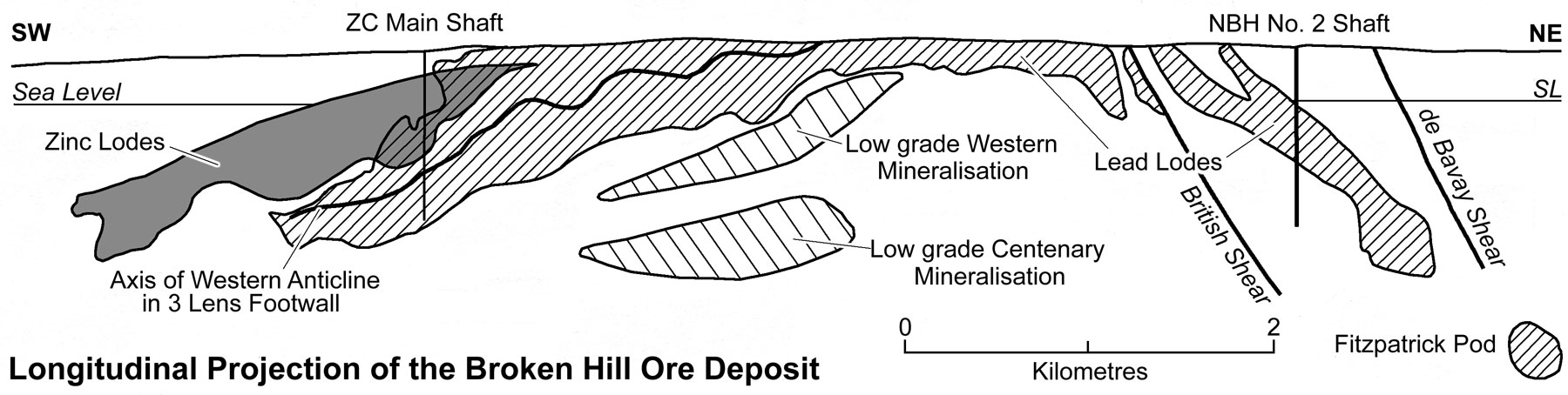
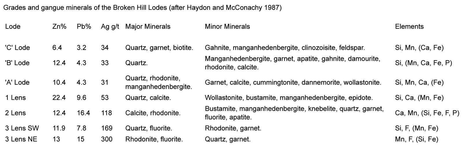
The nine, folded, linear, elongate Broken Hill ore lodes are distributed over a strike length of 7.3 km, a 'stratigraphic thickness' of less than 150 m and down dip extent of 300 to 1000 m. The lodes include, from the structural footwall, upwards (see cross section above), the No.s 3, 2 and 1, the A, B and C lodes and their splits. The No. 3, 2 and 1 Lodes (the 'Lead Lodes') are characterised by massive, coarsely-crystalline, galena and sphalerite, with average grades of 8 to 16% Pb, 12 to 22% Zn and 50 to 300 g/t Ag in a gangue dominated by similarly coarsely-crystalline quartz, calcite and rhodonite. The structurally higher, or 'Zinc Lodes' contain a higher proportion of sphalerite are less massive, not as coarse, and have a predominantly quarz and garnet gangue, with grades of 3 to 4% Pb, 6 to 12% Zn and 30 to 35 g/t Ag. The 'Lead Lodes' are best developed and predominate in the northern sections of the line of lode, while the 'Zinc Lodes are more significant in the Southern Leases.
Each of the lodes overlaps the lode above and below along the direction of elongation. They are steeply dipping, but exhibit a shallowly doubly plunging 'coat hanger-like' structure extending below the surface to the north and south of the exposed apex. The orebodies are restricted to two adjacent tight 'drag folds' over the full length of the line of lode. Within these structures, the ore occupies the keel of an eastern synform, the crest of a western antiform, their common limb and a shear zone merging into the eastern limb of the synform. The elongation and plunge of the lodes and the alignment of their vertical en echelon development parallels the F2 and F3 fold axes, both locally and regionally, while the elongation of the lodes corresponds closely to the orientation of the L1-2 lineation and L1 where it is distinguishable from L2.
Within the Broken Hill orebody, markedly transgressive high grade ore extend upwards and downwards from the orebody. These developments are known locally as 'droppers', and carry up to 42% combined metal, although typically assaying around 15% Zn, 10% Pb, 80 g/t Ag. Droppers range from simple cusp features to major piercement structures up to 50 m or more in length. The droppers are often irregularly developed along strike, varying greatly in thickness between mine sections, generally with strike lengths of up to 120 m. Droppers may comprise up to 10 m thick of high grade ore on one section, and be a barren shear on the next 20 m spaced section. Examples are described in more detail in the Discussion below.
The orebodies origninally outcropped as a >1 km long by 30 to 40 m wide manganiferous gossan on a long narrow ridge formed by the resistant siliceous lode rocks which stood approximately 50 m above the surrounding gneisses. The gossan was characterised by coronadite, limonite, pyrolusite, psilomelane, quartz and garnet with minor cerussite, silver halides, pyromorphite and a little galena, that assayed from 60 to 900 g/t Ag and 10 to 15% Pb, although leaching of Zn was almost complete. Generally oxidation was complete to 100 m and in places below 200 m, while the outcropping zone of Fe and Mn oxides extended to an average depth of 75m.
Away from the main high grade lodes detailed above there are substantial tonnages of low grade mineralisation, examples of which are the Western Mineralisation (300 m down dip to the NNW of the main lodes in the Kintore-Delprat shafts interval) which surrounds a higher grade core of comprises 15 Mt @ 3.2% Zn, 2.5% Pb, 31 g/t Ag; the Centenary Mineralisation, (across the Globe Vauxhall Shear Zone to the NW of the Western Mineralisation) estimated to contain a higher grade core of 9 Mt @ 3.2% Zn, 2.1% Pb, 33 g/t Ag; and the White Leeds Mineralisation 1.5 km to the SW and up dip from the southern leases which contains 2.5 Mt @ 2% Zn, 2% Pb 30 g/t Ag. The Western and Centenary Mineralisation zones have dimensions of the order of 2000 x 250 m and 1400 x 300 m respectively, plunging generally parallel to the main orebodies up dip. Lower grade dispersed to strongly geochemically anomalous base metals are found between the higher grade zones along strike and up and down dip, as reflected by the regional distribution of the 'lode rocks'.
The Western Mineralisation occurs within a sequence of three stratabound sequences: i). a downdip extension of the garnet quartzite, composed of spessartine±rhodonite; ii). a hedenberg-rich unit equivalent to the B Lode and iii). a quartz-gahnite sequence equated with C Lode. The Centenary Mineralisation is located structurally below the Globe Vauxhall Shear which separates it from the Western Mineralisation, and may be stratigraphically equivalent. The Centenary Mineralisation appears mostly in blue quartz lode, with garnet and calc-silicate gangue in addition to the garnet quartzite. These low resources are higher grade cores within a lower grade mass of mineralisation estimated total ~100 Mt of >3% Pb+Zn mineralisation.
Away from the main orebody, 'lode rocks' with small massive sulphide accumulations and anomalous sulphide mineralisation has been traced over a cumulative strike length of 300 km. Within this mineralised trace, there are a number of other smaller zones of higher grade mineralisation, including the Potosi and Pinnacles and Silver Peak prospects and deposits. Potosi and Silver Peak are approximately 2 km north-east of the North Mine.
The Potosi deposit, which is also hosted by the Hores Gneiss, has been exploited as an open pit and occurs on the opposite limb of the 'Hanging Wall Synform' to the Broken Hill deposit which is to the south-west. The 'Hanging Wall Synform'is cut by two major sub-parallel structures, the Globe-Vauxhall and Western shear zones, and occurs between these two structures and are limited by the Potosi shear zone to the south-west. Mineralisation is dominantly coarse black, iron-rich sphalerite (marmatite) with lesser galena, chalcopyrite and pyrrhotite in a gangue of gahnite, garnet and blue-quartz. It occurs in four main ore types, i). stringers to sub-massive marmatite with 3 to 20% Zn; ii). 4 to 5 m thick zones of massive marmatite with a 'pebbly' durchbewegung texture, generally containing 30% Pb+Zn; iii). varying amounts of disseminated galena-chalcopyrite with fine veinlets and stringers of marmatite with lesser galena and chalcopyrite in a blue quartz, garnet and gahnite gangue, typically with 7% Pb+Zn; and iv). stringer marmatite in a blue quartz psammite, averaging 10% Pb+Zn. To the SW the mineralisation occupies a synformal structure, while to the NE it becomes a west dipping flexure as it approaches the Western Shear. In 1996, prior to mining the proved + probable reserve quoted by Pasminco was 1.0 Mt @ 2.3% Pb, 9.1% Zn, 28 g/t Ag in a 400 x 200 by 90 m deep pit outline. The indicated + inferred resource outside of the pit amounted to 1.8 Mt @ 3.7% Pb, 13.7% Zn, 45 g/t Ag, 0.28% Cu.
The Pinnacles Mine, some 17 km to the south-west of Broken Hill comprises 0.15 Mt @ 2.5% Zn, 11% Pb, 500 g/t Ag which has been mined from one of six generally 2 to 4 m (locally up to 15 m) thick concordant lodes distributed over a 150 m stratigraphic thickness. The lodes are siliceous (quartzites) with garnet, gahnite, hedenbergite, galena and sphalerite with minor pyrrhotite, chalcopyrite, arsenopyrite and pyrite within or adjacent to a quartz-magnetite rock. The mineralisation occurs in a strongly folded interval between two retrograde schist zones. The host has prominent quartz-magnetite and fine sodic plagioclase-quartz rock components. This lode zone and the other similar occurrences within the Willyama Inlier, is within the Suite 3 Thackaringa Group, which lies below the Broken Hill Group that hosts the main Broken Hill lodes.
Discussion - Distribution and Controls of Mineralisation
The orebodies at Broken Hill are restricted to Unit 4.7 of the Suite 4 Broken Hill Group within the Willyama Supergroup. The mineable ore deposit occupies eight separate stratigraphic positions within the 7.3 km of continuous strike length over which the orebody is developed. Ore lenses within these eight stratigraphic positions virtually completely overlap vertically, parallel to their elongation, within a stratigraphic interval of approximately 150 m. However while these ore lenses show a close vertical correspondence within the 'Belt of Attenuation', their strike extent from NE to SW results in a progressive offset with the stratigraphically lowest 'C' Lode being restricted to the southern leases, as are the other 'zinc lode' bodies, 'B' and 'A' Lodes and No. 1 Lens. The southern limit of No. 2 Lens is north of the southern termination of the 'zinc lodes, while the corresponding end of the stratigraphically higher No. 3 Lens is further NE again.
While the original pre-erosion 'lead lodes' appear to have been continuously developed, the 'zinc lodes' are present as several lenses separated by lower grade intervals.
The individual ore lenses are markedly elongated. The width of the 'zinc lode' lenses is generally of the order of 250 to 300 m in contrast to a strike length of 2.5 to 3 km, while the 'lead lodes' are from 500 to 600 m wide with a strike length of 6 to 6.5 km. The exception is the No. 2 lens where it is markedly attenuated within the Main Shear in the ZC leases and consequently is up to 1200 m across.
All of the high grade economic mineralisation appears to be located within the 'Belt of Attenuation' as described by Gustafson, et al., (1950) and discussed above in the 'Structure' segment. Carruthers (1965) stated .."That there is a remarkable association of ore and folds is not questioned". He went on to argue however that the folds were a result of the location of the ore rather than the converse. However as can be seen from the plan above and the discussion in the 'Structure' segment above, these structures involve a far broader stratigraphic interval than the immediate orebodies, which tends to counteract the latter argument.
As detailed above, the elongation of the ore lenses and the alignment of their vertical en echelon development lies within the 'Belt of Attenuation' and parallels the F2 and F3 fold axes, both locally and regionally. In addition the plunge of the orebodies and their elongation corresponds closely to the orientation of the L1-2 lineation and L1 where it is distinguishable from L2.
Empirically ore is restricted to 'Belt of Attenuation' which to date has only been found on the common limb between the tight Broken Hill Antiform and the adjacent Hangingwall Synform. This zone of attenuation may largely be related to the thrust core of the Broken Hill Antiform. Within the 'Belt of Attenuation' ore is localised within the following structural positions,
• The attenuated and sheared out core of a synformal dragfold structure and the adjacent limbs, but generally progressively thinning and lensing out away from the nose.
• The crest and common limb of an adjacent antiform, again thinning and fading out progressively away from the crest within less than 100 m. An exception is the 'Western A Lode' which re-develops on the western limb of the Western Anticline drag fold anticlinal limb adjacent to, and terminated by, the Termination Shear.
• As thin, but high grade vein like massive developments within the 'Main Shear System' shear zone adjacent to where it cuts the ore bearing band. This style of mineralisation is most obvious in the old Broken Hill South and MMM leases where thin planar bodies of ore follow the Main and Thompson Shears. This Main Shear ore passes into the old ZC (Southern) leases where it merges into the ore of the attenuated eastern limb of the Eastern Synform.
The plunge reversals along the Western Antiform-Eastern Synform described in the 'Structure' segment above, appear to closely coincide with the margins of ore lens. For instance the first appearance of the main 'zinc lodes' occurs immediately to the south of an abrupt local steepening of the plunge of the Eastern Synform, while the main No. 3 Lens terminates immediately north of a plunge reversal interval. Low grade intervals within the 'zinc lodes' also correspond to intervals where the plunge reversals offset the overall detailed trend of the ore zone. These plunge reversals correspond to oblique cross shears.
However as Carruthers (1965) pointed out there is a very strong stratigraphic control on the ore, with individual ore lenses faithfully following a single stratigraphic position over the whole length of the line of lode. In addition each of the lodes/lenses occupying a given stratigraphic position has a unique suite of gangue minerals and Zn:Pb ratio. The proportion of gangue minerals and metal ratios however may vary progressively within a given ore lens.
Haydon and McConachy (1987) have shown that the ore is contained within predominantly psammitic beds of Unit 4.7 of Suite 4, the Broken Hill Group, with lower grade mineralisation in internal and adjacent pelitic gneisses. This imposes the close stratigraphic control on the ore lenses that is observed, with the different psammite bands having different gangue and ore mineral assemblages.
Away from the structural positions detailed above there are substantial tonnages of low grade mineralisation, examples of which are the Western and Centenary and White Leeds mineralisation listed above. Lower grade dispersed to strongly geochemically anomalous base metals are found between the higher grade zones along strike and up and down dip, as reflected by the regional distribution of the 'lode rocks'.
Weakly mineralised surface exposures are evident for several km to both the NE and SW of the economic lodes at Broken Hill. This mineralisation consists of stratigraphically controlled layers of quartzite and siliceous gneiss containing persistent traces of Pb and Zn with some or all of the minerals pyrrhotite, manganese garnet, blue quartz, gahnite, green K feldspar and rhodonite (Carruthers 1965).
A significant number of small, concordant, high grade 'Broken Hill' like occurrences are distributed throughout the Broken Hill Block, confined largely to the Purnamoota Subgroup of the Broken Hill Group, while lode rocks similar to those described along strike from Broken Hill are also widespread, locally extending semi-continuously over strike lengths of 1 to 20 km and embracing these small high grade occurrences (Carruthers 1965). Johnson and Gow (1975) state that the 'lode horizon' is known over a cumulative strike length of 300 km, and commonly outcrops over widths of 1 to 200 m. This includes the lode rock developments along strike from the Broken Hill mines and the other areas away from the mine mentioned above. While a number of the concordant high grade sulphide masses have been exploited in the past, they generally only individually totalled a few hundred tonnes of ore. All of these occurrences lie within the southern and eastern two thirds of the exposed Willyama Inlier.
One of the other more significant styles of mineralisation within the district is known as the Thackaringa type and comprises transgressive galena-siderite veins developed within D3 retrograde shear zones. The largest example was the Umberumberka mine at Silverton which produced 0.04 Mt @ 20 to 30% Pb, 2000 g/t Ag.
At a number of localities mineralisation is associated with quartz-magnetite units, e.g., the Pinnacles Mine as described above.
Within the Broken Hill orebody markedly transgressive high grade ore extend upwards and downwards from the orebody. These comprise the 'droppers' described above. One of the best developed is the Zinc Lode Dropper which occurs immediately to the west of the keel synform in 'B' Lode and extends upwards to cut 'C' Lode and downwards through 'A' Lode. It has a continuous strike length of 1.6km, is 15m thick at its broadest, but may be as thin as 0.1m, with the thickness varying irregularly giving the appearance of pinch and swell structure. It is generally found in close proximity to the hinge zone of a major fold and in many cases occupies the axial plane of the Western Antiform. Stockfeld (1992) records that the Zinc Dropper is represented by a variety of rock types, ore textures and mineral assemblages which differentiate it from the main lode horizon. The most common style of mineralisation is a high grade band of ore which generally consists of rounded quartz clasts contained in a matrix of stained sulphide, at times resembling pebbly ore. Associated large very coarse grained quartz-sulphide veins are sporadically developed, comprising very coarsely crystalline white quartz, with lesser galena, sphalerite, pyrrhotite and chalcopyrite which are also coarsely crystalline. Maiden et al., (1986) describes the 'lead lode' droppers as comprising fragments of wall rock and silicate rich ore (if competent) set in a matrix of recrystallised sulphides, yielding grades enriched in Ag relative to the normal 'lead lodes'. Within the 'lead lode' droppers there is commonly a foliation developed parallel to the dropper margins. Sulphide bearing quartz veins similar to those described by Stockfeld, are developed from the extremities of the 'lead lode' droppers (Maiden et al., 1986). Droppers, smaller piercement massive sulphide 'veins' and cusps are commonly developed within more competent wall rocks adjacent to massive sulphides. These transgressive features are interpreted as being late stage (D3) structurally induced, chemically and physically remobilised sulphides. The ore within the droppers exhibits "Durchbewegung" textures.
O'Driscoll (1953) reports that the percentage of sulphides is particularly high in the centres of the large masses of sulphide within the main 'lead lodes', where ore assaying around 25% Pb, together with up to 20% Zn is commonly found. In such places the structure, elsewhere interpreted by calcitic banding, is obliterated or is revealed only by highly contorted unconnected remnants, and at times a brecciated texture with clasts of other more competent ore/gangue types, such as 1 to 2 cm rhodonite fragments. This implies substantial recrystallisation and remobilisation of ore within the main lodes as well as in the droppers described above.
Another of the common features of high grade 'lead lode' mineralisation is for the margins of the ore to be defined by narrow shears marking an abrupt change over <1 m from high grade ore to completely barren gneiss. This implies differential shear movement between rock types of different competence during deformation and/or mechanical mobilisation of ore relative to the embracing country rock.
On the north-eastern end of the mine the orebody plunges to the NE between the east dipping British and de Bavay shears, but also approaches the Globe Vauxhall Shear zone obliquely. It encounters the latter before reaching the de Bavay Shear, and is displaced by the barren shear zone some 200 m downward and 500 m to the north. The orebody has been located again, occurring as a smaller pod of high grade ore known as the Fitzpatrick Area, which is sandwiched between the main Globe Vauxhall Retrograde Shear and the parallel Western Shear 200 to 300 m to the NW. This pod occupies the tight synformal keel zone of the Eastern Synform between the two shear zones and comprised 4.8 Mt @ 9.5% Zn, 11.5% Pb, 180 g/t Ag (Leyh and Hinde 1990).
Origin - Large and Crawford (2010) note that the Broken Hill Pb-Zn-Ag deposits are hosted by high metamorphic grade arkosic sediments within a regional sequence that varies from quartzo-feldspathic to pelitic dominant. Tholeiitic metagabbroic sills form a significant component of the regional host package. In the immediate deposit area, the meta-arkosic sediments are accompanied by amphibolite, felsic gneiss, minor units of BIF and quartz-garnet-gahnite lithologies. They note that the deposit has a pronounced alteration halo that extends over at least 3 to 4 km along strike beyond the line of lode, and may be up to 500 m thick, defined by garnet spotting and increasing enrichment in K-Rb-Fe-Mn-Pb, and depletion of Na-Ca-Mg-Sr, towards mineralisation. Early interpretations favoured syn-kinematic or post-kinematic, often replacement-related origin for the mineralisation, in which ore fluids were closely linked with the granulite to amphibolite facies metamorphism and deformation. However, subsequent studies indicated that both the ores and their surrounding pronounced stratabound alteration halo existed prior to peak metamorphism, and that mineralisation was present some 80 m.y. before the major deformation event. Since then, models evolved from an essentially syn-sedimentary exhalative process (SEDEX), to a dominantly inhalative processes just below the seafloor, forming the stacked ore lenses over a 5 to 6 m.y. period, synchronous with or shortly after deposition of the host sediments (cf., Laisvall in Sweden). Neither of these models is consistent with the restricted range of δ34S isotopic values from the Broken Hill lode sulphides, which cluster around 0, and magmatic S/Se values. These values are homogeneous, and totally mantle-like, with minimal evidence for seawater-derived S, suggesting an igneous source for the S in the deposit.
A detailed study of the trace element and isotopic geochemistry of the extensive mafic sills in the Broken Hill Block (Crawford and Maas, 2009) has resulted in the development of an alternative model. Crawford and Maas (2009) argue that the Broken Hill Pb-Zn ore metals and S were ultimately derived from very strongly fractionated rift ferrotholeiite magmas emplaced along a major detachment around 1685 Ma that was associated with the extension and commencement of breakup of the Nuna-Columbia super-continent. They propose that highly evolved Fe-rich melts were forced out of intercumulus sites in gabbros up the detachment by synkinematic fractionation, to crystallise as very Fe-rich oxide gabbros. They also state that fractional crystallisation very effectively separates Cu from Pb and Zn, since Cu partitions strongly into a magmatic vapour phase from the early stages of fractionation, whereas lithophile Pb and Zn remain in the magma as fractionation proceeds. They suggest late magmatic fluid evolution from these Fe-rich magmas which transported large amounts of Pb and Zn via a saline-rich hydrothermal fluid that ultimately deposited those metals as massive and/or disseminated sulphide lenses beneath the seafloor, higher in the section along the trace of the extensional shear system. The abundant Mn, a characteristic of the Broken Hill ores and alteration halo, is ascribed to alteration of ilmenite (typically 0.5 to 2% MnO), a major phase in oxide gabbros. The major Thorndale gravity anomaly, centred east of, and bordered on its western margin by the Broken Hill Line of Lode, probably reflects the presence of these ferrogabbros on a major east-dipping crustal structure, the outcrop of which may define the line of lode. This model does not require the involvement of seawater-derived fluids, nor of metal extraction from the metasedimentary pile. New Pb isotope data for the metagabbroic sills (amphibolites) in the Broken Hill Block (Crawford and Maas, 2009) strongly supports this model. (The preceding paragraphs are paraphrased from Large and Crawford, 2010).
In addition, however, the structural relationships within the lode suggest structural remobilisation of ore, while Frost et al., 2011, observe that the massive sulphides exhibit strong evidence of melting, and suggest that during peak metamorphism, at temperatures of >750°C and 5 kbars pressure, the main Broken Hill orebody was partially molten, with much of the Pb, Cu, Ag, Sb and As in the melt, and the Fe and Zn residing in the restite. They also suggest that the main sulphide melt froze after the last penetrative deformation at temperatures of <720°, with a geometry and distribution determined by the structural dynamics during peak metamorphism.
History - The main Broken Hill deposit was recognised by Charles Rasp in 1883 as a gossan outcrop, following the discovery in 1882 of high grade Ag and Pb-Ag at Thackaringa and Silverton 20 to 30 km to the west. Charles Sturt had first collected samples from the Broken Hill ridge in 1844, but abandoned them when in danger of perishing in the desert later in the expedition. Mining has been continuous from 1883 to the present. Early mining was concentrated on the exposed gossans of the central hump of the line of lode by the company that became the Broken Hill Proprietry Company Limited (BHP). The northern down-plunge limb of the deposit was worked by a series of mines, which in 1885 were consolidated into the North Mining Company, later to become North Broken Hill Ltd (NBH). In 1885, Broken Hill South Limited (BHS) acquired leases adjacent to the BHP mines, and by 1940 had purchased the BHP leases to control the central part of the line of lode, the Central Leases, between the NBH and the Southern Leases. BHP had mined 13.43 Mt @ 12.5% Pb, 470 g/t Ag, 5.0% Zn before their departure from the field in 1940. The other early mines acquired by BHS in the Central Leases are estimated to have mined around 13.21 Mt of high grade ore.
Zinc Corporation Limited commenced mining on the Southern Leases over the southern down-plunge extensions of the line of lode in 1911. The associated New Broken Hill Consolidated (NBHC) mine started operations in 1937 on the continuation of the southern limb of the line of lode immediately to the south of the Zinc Corporation leases. A third shaft complex, the Southern Cross mine, was established as part of the ZC-NBHC operation as the southern continuation of the NBHC mine in the 1970's.
The four mines, NBH, BHS, ZC and NBHC, worked the line of lode on a large scale until BHS ceased operation in 1972. The Central Leases of BHS were acquired by Minerals, Mining and Metallurgy Limited (MMM) in 1972, who commenced an open pit to extract lower grade ore, remnants and mineralised dumps until 1990. Until it ceased operations, BHS had extracted 19.77 Mt @ 12.8% Pb, 170 g/t Ag, 7.7% Zn. By 1990, the total production on the Central Leases, including that of BHP, BHS, MMM and other early mines in the Central Leases had totalled 51.9 Mt of ore. The Central leases were taken acquired from MMM by Consolidated Broken Hill Limited but closed in mid-2008. Operations were restarted as the new CBH Resources Limited 0.65 Mtpa Rasp mine in 2012. Following a takeover in late 2010, CBH Resources Limited became a wholly owned subsidiary of Toho Zinc Co., Ltd, a Japanese company listed on the Tokyo Stock Exchange.
In 1988, the operations of NBH, and the ZC-NBHC mines of ZC Mines Pty Ltd were amalgamated, with other operations of the same companies to form Pasminco Mining Ltd. Until its closure in 1993, the North Mine, operated initially by NBH and later by Pasminco, had mined approximately 34 Mt @ 14% Pb, 230 g/t Ag, 11.5% Zn to a depth of 1700 m. By 1987, just prior to the formation of Pasminco the Southern Mines of ZC-NBHC had produced more than 73.5 Mt @ 11.1% Zn, 10.2% Pb, 78 g/t Ag.
In late 2001, Pasminco was liquidated and the company's Broken Hill operations were purchased by Perilya in early 2002 who have continued the operation until the present (2013). On 19 December 2013 Perilya Limited was 100% acquired by Shenzhen Zhongjin Lingnan Nonfemet Company Limited and delisted from the ASX. Perilya Limited continues operations at Broken Hill as a wholly owned subsidiary of Zhongjin Lingnan.
The 3.8 km long Central Leases held by CBH Resources Ltd contain the Kintore open pit mine developed on the main upper sections of the line of lode, and the down dip 'Western Mineralisation' zone that was too low grade to have been exploited when held by BHS.
The original pre-mining ore deposit (as quoted by Morland and Webster, 1998) consisted of 185 Mt of mineable ore, including 150 Mt @ >20% combined Pb+Zn. It has been estimated that approximately 60 Mt of ore was eroded from the original ore deposit. In addition there are ~100 Mt of >3% Pb+Zn mineralisation.
In late 1997 proven + probable reserves totalled 33.5 Mt @ 8.2% Zn, 5.1% Pb, 51 g/t Ag.
In mid 2007 the reserves and resources quoted by Perilya (2007) for the Northern and Southern Leases sections of their operation were:
Southern Operation - measured + indicated + inferred resource: 11.47 Mt @ 9.9% Zn, 7.6% Pb, 73 g/t Ag,
proved + probable reserve: 11.198 Mt @ 6.7% Zn, 4.9% Pb, 49 g/t Ag,
North Mine - measured + indicated + inferred resource: 0.165 Mt @ 6.6% Zn, 6.5% Pb, 108 g/t Ag,
proved + probable reserve: 0.046 Mt @ 4.5% Zn, 4.0% Pb, 87 g/t Ag,
North Mine Deeps - measured + indicated + inferred resource: 3.7 Mt @ 11.3% Zn, 13.5% Pb, 219 g/t Ag,
proved + probable reserve: 0.046 Mt @ 4.5% Zn, 4.0% Pb, 87 g/t Ag,
Potosi North - indicated + inferred resource: 0.304 Mt @ 12.7% Zn, 7.2% Pb, 64 g/t Ag,
Potosi Extended - inferred resource: 1.729 Mt @ 12.6% Zn, 2.9% Pb, 45 g/t Ag,
Flying Doctor - inferred resource: 0.52 Mt @ 5.4% Zn, 7.1% Pb, 72 g/t Ag,
Silver Peak - inferred resource: 0.335 Mt @ 5.9% Zn, 11.1% Pb, 91 g/t Ag,
Total Resource - 18.223 Mt @ 10.2% Zn, 8.4% Pb, 101 g/t Ag,
Total Reserve - 11.224 Mt @ 6.7% Zn, 4.9% Pb, 50 g/t Ag.
In mid 2007 the remaining resources of the Central Leases to a depth of 600 m were quoted by CBH Resources (2007) as:
10.1 Mt @ 4.9% Zn, 3.5% Pb, 43 g/t Ag.
The last JORC compliant publicly announced ore reserve and mineral resource figures for all Broken Hill operations, as at 30 June, 2012, released by Perilya Limited prior to the Zhongjin Lingnan takeover and delisting in 2013, were (Perilya ASX release, December 2012):
Southern Operation - measured + indicated + inferred resource: 11.7 Mt @ 9.3% Zn, 6.8% Pb, 72 g/t Ag,
proved + probable reserve: 11.7 Mt @ 6.2% Zn, 4.8% Pb, 50 g/t Ag,
North Mine Uppers - measured + indicated + inferred resource: 1.00 Mt @ 7% Zn, 9% Pb, 140 g/t Ag,
North Mine Deeps - measured + indicated + inferred resource: 3.3 Mt @ 11.5% Zn, 13.8% Pb, 239 g/t Ag,
Potosi - inferred resource: 1.60 Mt @ 14% Zn, 3% Pb, 46 g/t Ag,
Silver Peak - inferred resource: 0.400 Mt @ 5% Zn, 9% Pb, 77 g/t Ag,
Central Blocks - inferred resource: 0.700 Mt @ 5% Zn, 4% Pb, 43 g/t Ag,
Flying Doctor - indicated + inferred resource: 1.50 Mt @ 3% Zn, 4% Pb, 44 g/t Ag,
Henry George - inferred resource: 1.30 Mt @ 8% Zn, 1% Pb, 14 g/t Ag,
1130 - inferred resource: 0.20 Mt @ 12% Zn, 1% Pb, 7 g/t Ag,
Total Resource - 21.700 Mt @ 9.2% Zn, 7.0% Pb, 89 g/t Ag,
Total Reserve - 11.700 Mt @ 6.2% Zn, 4.8% Pb, 50 g/t Ag.
The most recent source geological information used to prepare this decription was dated: 2015.
Record last updated: 11/12/2016
This description is a summary from published sources, the chief of which are listed below.
© Copyright Porter GeoConsultancy Pty Ltd. Unauthorised copying, reproduction, storage or dissemination prohibited.
Broken Hill
|
|
|
Selected References:
|
Barnes, R.G., 1987 - Multi-stage mobilization and remobilization of mineralization in the Broken Hill Block, Australia: in Ore Geology Reviews v.2, pp. 247-267.
|
Burton G 1998 - Stratiform Pb-Zn-Ag mineralisation in the Broken Hill and Euriowie Blocks: in Gibson G M 1998 Broken Hill Exploration Initiative: Abstracts of papers presented at fourth annual meeting in Broken Hill, October 19-21, 1998 AGSO, Canberra Record: 1998/25 pp 1-4
|
Cartwright I 1999 - Regional Oxygen isotope zonation at Broken Hill, New South Wales, Australia: large-scale fluid flow and implications for Pb-Zn-Ag mineralization: in Econ. Geol. v94 pp 357-374
|
Conor. C.H.H. and Preiss, W.V., 2008 - Understanding the 1720-1640Ma Palaeoproterozoic Willyama Supergroup, Curnamona Province, Southeastern Australia: Implications for tectonics, basin evolution and ore genesis: in Precambrian Research v.166, pp. 297-317.
|
Donaghy A, Gibson G, Nutman A, Hall M, Maidment D 1999 - Rethinking the Palaeoproterozoic geological history of Broken Hill, NSW, Australia: Speculation towards a synthesis of structure, geochronology and lithological mapping: in http://acrc.earth.monash.edu.au/ACRC/ Conferences/HallsGapOrg/TonyDonagh 2p
|
Fitzherbert, J.A. and Downes, P.M., 2015 - A concise geological history of the Broken Hill region: in New South Wales Department of Trade and Investment, Geological Survey of New South Wales, Quarterly Notes, No. 143, pp. 29-43
|
Fitzherbert, J.A., 2015 - Refined peak and retrograde metamorphic isograds for the Broken Hill and Euriowie blocks, NSW: in New South Wales Department of Trade and Investment, Geological Survey of New South Wales, Quarterly Notes, No. 143, pp. 1-27.
|
Frost B R, Swapp S M and Mavrogenes J, 2011 - Textural Evidence for Extensive Melting of the Broken Hill Orebody : in Econ. Geol. v.106 pp. 869-882
|
Gibson G 1998 - Regional structure in the Willyama Supergroup and its relevance to mineral exploration in the Broken Hill Inlier: in Gibson G M 1998 Broken Hill Exploration Initiative: Abstracts of papers presented at fourth annual meeting in Broken Hill, October 19-21, 1998 AGSO, Canberra Rec: 1998/25 pp 38-40
|
Groves I M, Groves D I, Bierlein F P, Broome J and Penhall J, 2008 - Recognition of the Hydrothermal Feeder to the Structurally Inverted, Giant Broken Hill Deposit, New South Wales, Australia: in Econ. Geol. v103 pp 1389-1394
|
Haydon R C, McConachy G W 1987 - The stratigraphic setting of Pb-Zn-Ag mineralization at Broken Hill: in Econ. Geol. v82 pp 826-856
|
Heimann A, Spry P G, Teale G S, Conor C H H and Leyh W R, 2009 - Geochemistry of Garnet-Rich Rocks in the Southern Curnamona Province, Australia, and Their Genetic Relationship to Broken Hill-Type Pb-Zn-Ag Mineralization: in Econ. Geol. v104 pp. 687-712
|
Huston D L, Wyborn L, Stevens B 1998 - Pb-Zn-Ag mineral systems: An example from Broken Hill: in Gibson G M 1998 Broken Hill Exploration Initiative: Abstracts of papers presented at fourth annual meeting in Broken Hill, October 19-21, 1998 AGSO, Canberra Rec: 1998/25 pp 59-63
|
Johnson I R, Klinger G D 1975 - Broken Hill ore deposit and its environment: in Knight C L, (Ed.), 1975 Economic Geology of Australia & Papua New Guinea The AusIMM, Melbourne Mono 5 pp 476-491
|
Large R R and Crawford A J, 2010 - Basin-Hosted Stratiform Zinc Deposits: the Southern Hemisphere Perspective: in Archibald S M (Ed.), 2010 Proceedings of the Zinc2010 Meeting, Cork 2010, Irish Association for Economic Geology pp. 118-122
|
Leach D L, Bradley D C, Huston D, Pisarevsky S A, Taylor R D and Gardoll S J, 2010 - Sediment-Hosted Lead-Zinc Deposits in Earth History : in Econ. Geol. v.105 pp. 593-625
|
Mackenzie D H, Davies R H 1990 - Broken Hill Lead-Silver-Zinc deposit at Z.C. Mines: in Hughes F E (Ed.), 1990 Geology of the Mineral Deposits of Australia & Papua New Guinea The AusIMM, Melbourne Mono 14, v2 pp 1079-1084
|
Mavrogenes J A, MacIntosh I W, Ellis D J 2001 - Partial melting of the Broken Hill Galena-Sphalerite ore: Experimental studies in the system PbS-FeS-ZnS-(Ag2S): in Econ. Geol. v96 pp 205-210
|
Morland R, Leevers P R 1998 - Potosi zinc-lead-silver deposit, Broken Hill: in Berkman D A, Mackenzie D H (Eds), Geology of Australian and Papua New Guinean Mineral Deposits The AusIMM, Melbourne pp 615-618
|
Morland R, Webster A E 1998 - Broken Hill lead-zinc-silver deposit: in Berkman D A, Mackenzie D H (Eds), Geology of Australian and Papua New Guinean Mineral Deposits The AusIMM, Melbourne pp 619-626
|
NSW Department of Mineral Resources 1990 - Timely ideas on Broken Hill rocks -and- Cu-Au mineral systems and regional alteration, Curnamona Province: in Extracts from Minfo 62, New South Wales Mining & Exploration Quarterly (NSW Dept of Mineral Resources) pp 14-16, 22-24
|
Nutman A P, Ehlers K 1998 - Evidence for multiple Palaeoproterozoic thermal events and magmatism adjacent to the Broken Hill Pb-Zn-Ag orebody, Australia (Abstract only): in Precambrian Research v90 p 203
|
Page R W, Conor C H H, Stevens B P J, Gibson G M, Preiss W V and Southgate P N 2005 - Correlation of Olary and Broken Hill Domanins, Curnamona Province, Australia: Possible Relationship to Mount Isa and Other North Australian Pb-Zn-Ag-Bearing Successions: in Econ. Geol. v100 pp 663-676
|
Page R W, Stevens B P J and Gibson G M 2005 - Geochronology of the Sequence Hosting the Broken Hill Pb-Zn-Ag Orebody, Australia: in Econ. Geol. v100 pp 633-661
|
Parr J M, Stevens B P J, Carr G R and Page R W 2004 - Subseafloor origin for Broken Hill Pb-Zn-Ag mineralization, New South Wales, Australia: in Geology v32 pp 589-592
|
Pasminco Mining 1994 - Pasminco Mining Broken Hill operations, geological overview: in Pasminco Mining handout 24p
|
Phillips, G.N., 2008 - Origin of the Broken Hill silver-lead-zinc deposit: in AusIMM Bulletin, October 2008, pp. 32, 34-36, 38.
|
Sangster, D.F., 2020 - Evidence that Broken Hill-type Pb-Zn deposits are metamorphosed SEDEX deposits: in Mineralium Deposita v.55, pp. 1263-1270.
|
Sparks, H.A. and Mavrogenes, J.A., 2005 - Sulfide Melt Inclusions as Evidence for the Existence of a Sulfide Partial Melt at Broken Hill, Australia: in Econ. Geol. v100 pp 773-779
|
Spry P G, Heimann A, Messerly J D, Houk R S and Teale G S, 2007 - Discrimination of Metamorphic and Metasomatic Processes at the Broken Hill Pb-Zn-Ag Deposit, Australia: Rare Earth Element Signatures of Garnet-Rich Rocks: in Econ. Geol. v102 pp 471-494
|
Spry, P.G. and Teale, G.S., 2021 - A classification of Broken Hill-type deposits: A critical review: in Ore Geology Reviews v.130, 26p. doi.org/10.1016/j.oregeorev.2020.103935.
|
Stevens B J P 1998 - The origins of Broken Hill rock types and their relevance to mineralisation: in Gibson G M 1998 Broken Hill Exploration Initiative: Abstracts of papers presented at fourth annual meeting in Broken Hill, October 19-21, 1998 AGSO, Canberra Rec: 1998/25 pp 109-114
|
Stevens B P J 1996 - Regional geology of the Broken Hill and Euriowie Blocks: in Pongratz J and Davidson G J (Eds.), New developments in BrokenHill type deposits, University of Tasmania, CODES Special Publication 1 pp 11-15
|
Stevens B P J, Barnes R G, Forbes B G 1990 - Willyama Block - regional geology and minor mineralisation: in Hughes F E (Ed.), 1990 Geology of the Mineral Deposits of Australia & Papua New Guinea The AusIMM, Melbourne Mono 14, v2 pp 1065-1072
|
Stevens B P J, Burton G R 1998 - The early to late Proterozoic Broken Hill Province, New South Wales: in AGSO J. of Aust. Geol. & Geophys. v17, no. 3 pp 75-86
|
Stevens, B.P.J., Page, R.W. and Crooks, A., 2008 - Geochronology of Willyama Supergroup metavolcanics, metasediments and contemporaneous intrusions, Broken Hill, Australia: in Australian J. of Earth Sciences v.55, pp. 301-330.
|
van der Heyden A, Edgecombe D R 1990 - Silver-Lead-Zinc deposit at South Mine, Broken Hill: in Hughes F E (Ed.), 1990 Geology of the Mineral Deposits of Australia & Papua New Guinea The AusIMM, Melbourne Mono 14, v2 pp 1073-1077
|
Webster A E 1993 - Sulphide orebodies and structure: mapping within an orebody and what it can tell you - an example from Broken Hill NSW: in Proc. International Mining Geology Conference, Kalgoorlie, WA, 5-8 July 1993 The AusIMM, Melbourne pp 133-141
|
Webster, A.E., 2004 - The Structural Evolution of the Broken Hill Pb-Zn-Ag Deposit, New South Wales, Australia: in a thesis submitted in fulfilment of the requirements for the degree of Doctor of Philosophy, University of Tasmania July 2004, https://eprints.utas.edu.au/22134/, 517p.
|
White S H, Rothery E, Lips A W L, Barclay T J R 1995 - Broken Hill area, Australia, as a Proterozoic fold and thrust belt: implications for the Broken Hill base-metal deposit: in Trans. Instn. Min. Metall (Sect. B: Appl. earth sci.) v104, January-April 1995 pp B1-B17
|
|
Porter GeoConsultancy Pty Ltd (PorterGeo) provides access to this database at no charge. It is largely based on scientific papers and reports in the public domain, and was current when the sources consulted were published. While PorterGeo endeavour to ensure the information was accurate at the time of compilation and subsequent updating, PorterGeo, its employees and servants: i). do not warrant, or make any representation regarding the use, or results of the use of the information contained herein as to its correctness, accuracy, currency, or otherwise; and ii). expressly disclaim all liability or responsibility to any person using the information or conclusions contained herein.
|
Top | Search Again | PGC Home | Terms & Conditions
|
|


